


For 7000 ft. to 8000 ft.
| Saturday | Saturday Night | Sunday | |
|---|---|---|---|
| Weather: | Partly cloudy skies, becoming mostly cloudy. | Mostly cloudy skies with a chance of snow. | Mostly cloudy skies, becoming partly cloudy. A chance of snow. |
| Temperatures: | 41 to 47 deg. F. | 22 to 27 deg. F. | 28 to 33 deg. F. |
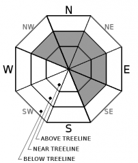
| Mid Slope Winds: | SW | SW | SW shifting to W |
| Wind Speed: | 10 to 15 mph with gusts to 30 mph, increasing to 20 to 30 mph with gusts to 60 mph in the afternoon. | 20 to 35 mph. Gusts up to 70 mph decreasing to 60 mph after midnight. | 20 to 30 mph with gusts to 50 mph, shifting and decreasing to 15 to 20 mph with gusts to 35 mph in the afternoon. |
| Expected snowfall: | 0 to trace | 1 to 3 | Likely 1 to 3 in. | Possible 4 to 5 |
For 8000 ft. to 9000 ft.
| Saturday | Saturday Night | Sunday | |
|---|---|---|---|
| Weather: | Partly cloudy skies, becoming mostly cloudy. | Mostly cloudy skies with a chance of snow. | Mostly cloudy skies, becoming partly cloudy. A chance of snow. |
| Temperatures: | 37 to 43 deg. F. | 19 to 25 deg. F. | 24 to 30 deg. F. |
| Ridge Top Winds: | SW | SW | SW shifting to W |
| Wind Speed: | 20 to 35 mph with gusts to 65 mph, increasing to 30 to 45 mph with gusts to 80 mph after midnight. | 30 to 55 mph with gusts to 95 mph, decreasing to 30 to 45 mph with gusts to 80 mph after midnight. | 30 to 40 mph with gusts to 85 mph, shifting and decreasing to 20 to 30 mph with gusts to 50 mph in the afternoon. |
| Expected snowfall: | 0 to trace | Likely 1 to 4 in. | Possible 4 to 6 | Likely 1 to 4 in. | Possible 4 to 6 |


