THIS AVALANCHE FORECAST EXPIRED ON December 7, 2017 @ 6:40 am
Avalanche Forecast published on December 6, 2017 @ 6:40 am
Issued by Andy Anderson - Tahoe National Forest - Sierra Avalanche Center

MODERATE avalanche danger will continue in near and above treeline terrain due to the hard wind slabs created by the strong NE winds. While these hard slabs may be difficult to trigger, human-triggered avalanches remain possible today. Identify where wind slabs exist and avoid steep wind-loaded terrain. Firm, scoured, or icy surfaces where arresting a fall would be challenging also exist on exposed near and above treeline terrain.

2. Moderate

?

Above Treeline
Heightened avalanche conditions on specific terrain features. Evaluate snow and terrain carefully; identify features of concern.

2. Moderate

?

Near Treeline
Heightened avalanche conditions on specific terrain features. Evaluate snow and terrain carefully; identify features of concern.

1. Low

?

Below Treeline
Generally safe avalanche conditions. Watch for unstable snow on isolated terrain features.
    Heightened avalanche conditions on specific terrain features. Evaluate snow and terrain carefully; identify features of concern.
Avalanche Problem 1: Wind Slab
  • Type ?
  • Aspect/Elevation ?
  • Likelihood ?
    Certain
    Very Likely
    Likely
    Possible
    Unlikely
  • Size ?
    Historic
    Very Large
    Large
    Small

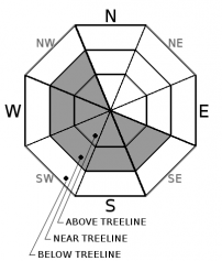
The strong E and NE winds since Sunday night have formed hard wind slabs on the wind-loaded W-SW-S aspects and on cross-loaded NW and SE aspects. These wind slabs exist in specific areas in near and above treeline terrain near ridgelines and have grown up to 18 inches in depth. These wind slabs rest on top of an older, looser layer of snow that could serve as a weak layer. Triggering these new wind slabs may be difficult due to the strength of the slab, but it is possible for the right trigger in the right place to cause an avalanche. If they do break, these hard wind slabs would likely break above the person who triggers them. Areas where a shallower wind slab exists, places near exposed rocks, convex rollovers, and unsupported slopes could represent some of the trigger points where breaking one of these hard slabs may be easier.

Use clues like blowing snow, hollow sounding snow, cornices above slopes, drifted snow, ripples in the snow surface, and other wind created textures to identify where wind slabs may exist and avoid those areas. Travelling in sheltered non-wind-affected terrain where softer snow still exists should provide safer and more enjoyable conditions today. 

recent observations

* Hard wind slabs existed on NW aspects on Castle Peak with a weaker layer of snow below them. Tests on these wind slabs yielded unstable results (ECTP's) that indicated that they might be difficult to trigger but if they do break, they could produce avalanches.

* Widespread firm, icy, scoured surfaces existed on exposed N-NE-E aspects on Chickadee Ridge, Basin Peak, and Castle Peak.

* NE winds continued to transport snow away from the N-NE-E aspects and onto the NW-W-SW-S-SE aspects during the day yesterday.

* Soft, unconsolidated snow still exists on near and below treeline northerly aspects sheltered from the E and NE winds. 

Snow coverage is deepest in areas above 8000 ft. in the northern half of the forecast area (north of Emerald Bay). Even at these elevations, snow coverage varies by location. Some areas at the upper elevations south of Emerald Bay still have marginal snow coverage. Below 8000 ft. most areas still have patchy snow coverage with many exposed obstacles and areas of bare ground. 

Weather and CURRENT CONDITIONS
weather summary

Yesterday's strong east winds started to decrease some overnight. They should continue to decrease this morning but may increase a bit more tonight as a weak disturbance passes by the forecast area. Temperatures have started to warm up at the higher elevations and should continue to increase over the next few days. Cold air trapped in the valleys overnight has kept the lower elevations several degrees colder. The forecast calls for clear dry weather while the high-pressure ridge remains in place over the region.

CONDITIONS ALONG THE SIERRA CREST BETWEEN 8200 FT. AND 9200 FT. IN THE LAST 24 HOURS
6am temperature: 24 to 32 deg. F.
Max. temperature: 32 to 38 deg. F.
Average ridgetop wind direction: Northeast
Average ridgetop wind speed: 40 mph
Maximum ridgetop wind gust: 78 mph
New snowfall: 0 inches
Total snow depth: 15 to 34 inches
Two-Day Mountain Weather Forecast Produced in partnership with the Reno NWS
For 7000 ft. to 8000 ft.
Wednesday Wednesday Night Thursday
Weather: Sunny Clear Sunny
Temperatures: 36 to 41 deg. F. 19 to 25 deg. F. 41 to 46 deg. F.
Mid Slope Winds: East East East
Wind Speed: Light in the morning increasing to 10 to 15 mph with gusts to 30 mph in the afternoon 10 to 15 mph with gusts to 40 mph 10 to 15 mph with gusts to 35 mph in the morning becoming light in the afternoon
Expected snowfall: 0 0 0
For 8000 ft. to 9000 ft.
Wednesday Wednesday Night Thursday
Weather: Sunny Clear Sunny
Temperatures: 35 to 40 deg. F. 19 to 24 deg. F. 39 to 44 deg. F.
Ridge Top Winds: East East East becoming southeast in the afternoon
Wind Speed: 15 to 25 mph with gusts to 30 mph increasing to 45 mph in the afternoon 20 to 35 mph with gusts to 60 mph 20 to 30 mph with gusts to 50 mph decreasing to 10 to 15 mph with gusts to 40 mph in the afternoon
Expected snowfall: 0 0 0
Disclaimer

This avalanche advisory is provided through a partnership between the Tahoe National Forest and the Sierra Avalanche Center. This advisory covers the Central Sierra Nevada Mountains between Yuba Pass on the north and Ebbetts Pass on the south. Click here for a map of the forecast area. This advisory applies only to backcountry areas outside established ski area boundaries. This advisory describes general avalanche conditions and local variations always occur. This advisory expires 24 hours after the posted time unless otherwise noted. The information in this advisory is provided by the USDA Forest Service who is solely responsible for its content.

For a recorded version of the Avalanche Advisory call (530) 587-3558 x258