THIS AVALANCHE FORECAST EXPIRED ON December 11, 2017 @ 6:45 am
Avalanche Forecast published on December 10, 2017 @ 6:45 am
Issued by Steve Reynaud - Tahoe National Forest

Avalanche danger is low throughout the forecast area.  Hard wind slabs in isolated near treeline and above treeline terrain still remain a concern but have become unlikely.  Watch for unstable snow on isolated terrain features.

1. Low

?

Above Treeline
Generally safe avalanche conditions. Watch for unstable snow on isolated terrain features.

1. Low

?

Near Treeline
Generally safe avalanche conditions. Watch for unstable snow on isolated terrain features.

1. Low

?

Below Treeline
Generally safe avalanche conditions. Watch for unstable snow on isolated terrain features.
    Generally safe avalanche conditions. Watch for unstable snow on isolated terrain features.
Avalanche Problem 1: Wind Slab
  • Type ?
  • Aspect/Elevation ?
  • Likelihood ?
    Certain
    Very Likely
    Likely
    Possible
    Unlikely
  • Size ?
    Historic
    Very Large
    Large
    Small

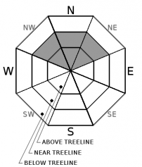
Areas of hard wind slab on top of low density old near surface facets remain in isolated areas on NW aspects and also on isolated N-NE aspects in near and above treeline terrain.  Most areas above treeline have been thoroughly scoured by the recent NE/E winds making it difficult to differentiate between wind scoured slopes and slopes that have hard wind slabs.  These hard wind slabs are extremely dense and strong making them unlikely to trigger in most areas.  Areas where these hard slabs are thinner or non supported still represent a concern; like the sides of gullies or in steep complex terrain.  

While these hard wind slabs are unlikely, any avalanche involving this problem would have large consequences with our low snowpack conditions.  Look for slopes with smooth, wind sculpted surfaces and avoid areas with any type of hollow sounding snow.

recent observations

-Hard wind slabs with underlying faceted snow found on Elephants Back (Carson Pass area) and Relay Peak (Mt. Rose area).

-Widespread firm, wind scoured snow surfaces found on most near and above treeline terrain.

-Snow coverage is deepest above 8000' in the northern part of the forecast region.  Minimal snow coverage exists below 8000'.  Decreasing snow coverage on southerly aspects at higher elevations. 

Weather and CURRENT CONDITIONS
weather summary

Strong high pressure will continue to bring clear skies, warm days, cold overnight lows, and valley inversions.  Light East winds will continue throughout the week.

CONDITIONS ALONG THE SIERRA CREST BETWEEN 8200 FT. AND 9200 FT. IN THE LAST 24 HOURS
6am temperature: 35 to 40 deg. F.
Max. temperature: 49 deg. F.
Average ridgetop wind direction: E
Average ridgetop wind speed: 15 to 25 mph
Maximum ridgetop wind gust: 41 mph
New snowfall: 0 inches
Total snow depth: 15 to 32 inches
Two-Day Mountain Weather Forecast Produced in partnership with the Reno NWS
For 7000 ft. to 8000 ft.
Sunday Sunday Night Monday
Weather: Sunny Clear Sunny
Temperatures: 45 to 50 deg. F. 25 to 33 deg. F. 47 to 52 deg. F.
Mid Slope Winds:
Wind Speed: Light winds. Light winds. Light winds.
Expected snowfall: 0 0 0
For 8000 ft. to 9000 ft.
Sunday Sunday Night Monday
Weather: Sunny Clear Sunny
Temperatures: 44 to 49 deg. F. 29 to 35 deg. F. 44 to 49 deg. F.
Ridge Top Winds: East
Wind Speed: 10 to 15mph with gusts to 25mph. Light winds. Light winds.
Expected snowfall: 0 0 0
Disclaimer

This avalanche advisory is provided through a partnership between the Tahoe National Forest and the Sierra Avalanche Center. This advisory covers the Central Sierra Nevada Mountains between Yuba Pass on the north and Ebbetts Pass on the south. Click here for a map of the forecast area. This advisory applies only to backcountry areas outside established ski area boundaries. This advisory describes general avalanche conditions and local variations always occur. This advisory expires 24 hours after the posted time unless otherwise noted. The information in this advisory is provided by the USDA Forest Service who is solely responsible for its content.

For a recorded version of the Avalanche Advisory call (530) 587-3558 x258