THIS AVALANCHE FORECAST EXPIRED ON December 12, 2017 @ 6:40 am
Avalanche Forecast published on December 11, 2017 @ 6:40 am
Issued by Steve Reynaud - Tahoe National Forest

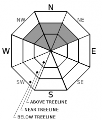
Low avalanche danger continues throughout the forecast area at all elevations.  Isolated hard wind slabs in near treeline and above treeline terrain represent an unlikely, but not impossible avalanche problem.  Look for unstable snow on isolated terrain features.

1. Low

?

Above Treeline
Generally safe avalanche conditions. Watch for unstable snow on isolated terrain features.

1. Low

?

Near Treeline
Generally safe avalanche conditions. Watch for unstable snow on isolated terrain features.

1. Low

?

Below Treeline
Generally safe avalanche conditions. Watch for unstable snow on isolated terrain features.
    Generally safe avalanche conditions. Watch for unstable snow on isolated terrain features.
Avalanche Problem 1: Wind Slab
  • Type ?
  • Aspect/Elevation ?
  • Likelihood ?
    Certain
    Very Likely
    Likely
    Possible
    Unlikely
  • Size ?
    Historic
    Very Large
    Large
    Small

Isolated hard wind slabs could exist on NW-N-NE aspects in near treeline and above treeline terrain.  Last weeks NE/E wind event has scoured most slopes near treeline and above and has created very dense and strong hard wind slabs.  Where these hard wind slabs sit on top of old near surface facets, snowpack tests have shown weakness with this combination. This avalanche problem has become unlikely to occur, but concern still exists on unsupported slopes and steep complex terrain.  

Any avalanche involving this problem could have large consequences with our low snowpack conditions.  Look for slopes with smooth, wind sculpted surfaces, and avoid areas with any type of hollow sounding snow.  

recent observations

-Snow coverage is deepest above 8000' in the northern part of the forecast region (areas above Emerald Bay).  Minimal snow coverage exists below 8000'.  In the southern part of the forecast area, snow coverage is deepest above 8500' with varying amounts of usable snow.  Snow coverage is decreasing on southerly aspects at higher elevations. 

-Hard wind slabs with underlying loose faceted snow observed on Needle Peak Ridge (Granite Chief Wilderness), Elephants Back (Carson Pass area) and Relay Peak (Mt. Rose area) during the last week.

-Widespread firm, wind scoured snow surfaces found on most near and above treeline terrain.

Weather and CURRENT CONDITIONS
weather summary

Strong high pressure continues with dry conditions, valley inversions, clear skies, and warm days.  High temperatures will be in the upper 40's at the higher elevations with light winds throughout most of the week.

CONDITIONS ALONG THE SIERRA CREST BETWEEN 8200 FT. AND 9200 FT. IN THE LAST 24 HOURS
6am temperature: 36 to 44 deg. F.
Max. temperature: 52 deg. F.
Average ridgetop wind direction: E
Average ridgetop wind speed: 10 to 20 mph
Maximum ridgetop wind gust: 38 mph
New snowfall: 0 inches
Total snow depth: 15 to 32 inches
Two-Day Mountain Weather Forecast Produced in partnership with the Reno NWS
For 7000 ft. to 8000 ft.
Monday Monday Night Tuesday
Weather: Mostly sunny Clear Sunny
Temperatures: 46 to 51 deg. F. 25 to 35 deg. F. 46 to 51 deg. F.
Mid Slope Winds:
Wind Speed: Light winds Light winds Light winds
Expected snowfall: 0 0 0
For 8000 ft. to 9000 ft.
Monday Monday Night Tuesday
Weather: Mostly sunny Clear Sunny
Temperatures: 44 to 49 deg. F. 29 to 37 deg. F. 44 to 49 deg. F.
Ridge Top Winds:
Wind Speed: Light winds Light winds Light winds
Expected snowfall: 0 0 0
Disclaimer

This avalanche advisory is provided through a partnership between the Tahoe National Forest and the Sierra Avalanche Center. This advisory covers the Central Sierra Nevada Mountains between Yuba Pass on the north and Ebbetts Pass on the south. Click here for a map of the forecast area. This advisory applies only to backcountry areas outside established ski area boundaries. This advisory describes general avalanche conditions and local variations always occur. This advisory expires 24 hours after the posted time unless otherwise noted. The information in this advisory is provided by the USDA Forest Service who is solely responsible for its content.

For a recorded version of the Avalanche Advisory call (530) 587-3558 x258