THIS AVALANCHE FORECAST EXPIRED ON December 17, 2017 @ 6:54 am
Avalanche Forecast published on December 16, 2017 @ 6:54 am
Issued by Brandon Schwartz - Tahoe National Forest

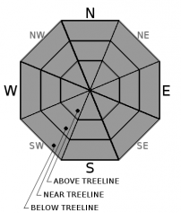
Avalanche danger is LOW for all elevations. On a regional scale, triggering an avalanche is unlikely. Signs of isolated, difficult to trigger slab instability continue to show both above and below treeline. Normal caution is advised.

1. Low

?

Above Treeline
Generally safe avalanche conditions. Watch for unstable snow on isolated terrain features.

1. Low

?

Near Treeline
Generally safe avalanche conditions. Watch for unstable snow on isolated terrain features.

1. Low

?

Below Treeline
Generally safe avalanche conditions. Watch for unstable snow on isolated terrain features.
    Generally safe avalanche conditions. Watch for unstable snow on isolated terrain features.
Avalanche Problem 1: Normal Caution
  • Type ?
  • Aspect/Elevation ?
  • Likelihood ?
    Certain
    Very Likely
    Likely
    Possible
    Unlikely
  • Size ?
    Historic
    Very Large
    Large
    Small

Yesterday's field observations continued to find isolated areas of difficult to trigger (stubborn) instability both above and below treeline on WNW to N aspects within the forecast area. Weak faceted snow below hard slabs in near and above treeline terrain as well as weak faceted snow below soft slabs in below treeline terrain continues to yield unstable snowpit test results. Human triggered avalanches up to size D2 are not impossible.

The isolated distribution and stubborn difficulty of triggering make avalanche activity on a regional scale an unlikely event. While it has been well over a week since any avalanche activity has been reported, the data continues to point out that instability remains. Use normal caution (best practice travel techniques) for travel in or around avalanche terrain to help improve the outcome in the unlikely event of a human triggered avalanche. More info on the meaning of normal caution can be found here.

Any blowing snow today is not expected to create new areas of instability.


recent observations

* Unstable snowpit test results were noted over the past two days from hard wind slabs over facets near and above treeline on WNW to NW aspects on Trimmer Peak (Luther Pass/Job/Freel area) and on Andesite Peak (Donner Summit area).

* Unstable snowpit test results were noted yesterday from soft slab over facets below treeline on a N aspect below Frog Lake Cliffs (Carson Pass area).

* Widespread firm, wind scoured snow surfaces exist on most aspects near and above treeline.

* Variable snow surfaces with some areas of softer snow exist near and below treeline in shaded, wind protected areas.

* Areas north of Emerald Bay above 8,000', hold decent snow coverage. Below 8,000' snow coverage remains patchy and shallow. South of Emerald Bay, less snow exists with areas below 8,500' holding very little snow.

* Snow coverage on southerly aspects has decreased due to melt throughout the forecast area.

Weather and CURRENT CONDITIONS
weather summary

A dusting of snow occurred in most areas last night and ridgetop winds shifted to NE around midnight. Winds are on the increase this morning with ridgetop gusts in the 75 to 100 mph range expected today and tomorrow. A short lived break from the persistent air temperature inversion conditions will occur today. Air temperature inversion is forecast to reestablish over the next couple of days with the coldest air on the mountain valley floors and significantly warmer temperatures on the peaks both day and night.


CONDITIONS ALONG THE SIERRA CREST BETWEEN 8200 FT. AND 9200 FT. IN THE LAST 24 HOURS
6am temperature: 19 to 27 deg. F.
Max. temperature: 44 to 51 deg. F.
Average ridgetop wind direction: SW shifting to NE
Average ridgetop wind speed: SW 30 mph | NE 37 mph
Maximum ridgetop wind gust: SW 57 mph | NE 64 mph
New snowfall: Trace to 1 inches
Total snow depth: 15 to 32 inches
Two-Day Mountain Weather Forecast Produced in partnership with the Reno NWS
For 7000 ft. to 8000 ft.
Saturday Saturday Night Sunday
Weather: Partly cloudy skies, becoming sunny. Scattered snow showers in the morning. Clear skies. Sunny skies.
Temperatures: 28 to 33 deg. F. 21 to 26 deg. F. 37 to 42 deg. F.
Mid Slope Winds: NE NE E
Wind Speed: 10 to 15 mph. Gusts to 45 mph increasing to 60 mph in the afternoon. 15 to 20 mph. Gusts to 65 mph decreasing to 55 mph after midnight. 10 to 15 mph. Gusts to 55 mph decreasing to 45 mph in the afternoon.
Expected snowfall: 0 to 1 0 0
For 8000 ft. to 9000 ft.
Saturday Saturday Night Sunday
Weather: Partly cloudy skies, becoming sunny. Scattered snow showers in the morning. Clear skies. Sunny skies.
Temperatures: 25 to 30 deg. F. 22 to 27 deg. F. 29 to 34 deg. F.
Ridge Top Winds: NE NE NE to E
Wind Speed: 20 to 30 mph with gusts to 60 mph, increasing to 30 to 45 mph with gusts to 80 mph in the afternoon. 30 to 45 mph with gusts to 90 mph. 30 to 45 mph with gusts to 90 mph, decreasing to 25 to 35 mph with gusts to 75 mph in the afternoon.
Expected snowfall: 0 to 1 0 0
Disclaimer

This avalanche advisory is provided through a partnership between the Tahoe National Forest and the Sierra Avalanche Center. This advisory covers the Central Sierra Nevada Mountains between Yuba Pass on the north and Ebbetts Pass on the south. Click here for a map of the forecast area. This advisory applies only to backcountry areas outside established ski area boundaries. This advisory describes general avalanche conditions and local variations always occur. This advisory expires 24 hours after the posted time unless otherwise noted. The information in this advisory is provided by the USDA Forest Service who is solely responsible for its content.

For a recorded version of the Avalanche Advisory call (530) 587-3558 x258