


For 7000 ft. to 8000 ft.
| Monday | Monday Night | Tuesday | |
|---|---|---|---|
| Weather: | Partly cloudy | Partly cloudy | Partly cloudy |
| Temperatures: | 40 to 45 deg. F. | 21 to 27 deg. F. | 45 to 50 deg. F. |
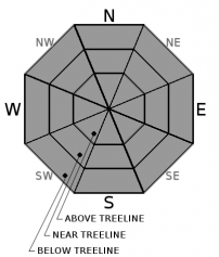
| Mid Slope Winds: | SW | ||
| Wind Speed: | Light winds | Light winds | 10 to 15mph with gusts to 30mph increasing to 20 to 30mph with gusts to 60mph in the afternoon. |
| Expected snowfall: | 0 | 0 | 0 |
For 8000 ft. to 9000 ft.
| Monday | Monday Night | Tuesday | |
|---|---|---|---|
| Weather: | Partly cloudy | Partly cloudy | Partly cloudy |
| Temperatures: | 37 to 42 deg. F. | 22 to 27 deg. F. | 42 to 47 deg. F. |
| Ridge Top Winds: | N | N shifting to W | W shifting to SW |
| Wind Speed: | 10 to 15mph with gusts to 25mph in the morning becoming light. | 10 to 15mph with gusts to 30mph shifting to the W with gusts up to 40mph after midnight. | 20 to 30mph with gusts to 50mph increasing to SW 30 to 45mph with gusts to 90mph in the afternoon. |
| Expected snowfall: | 0 | 0 | 0 |


