THIS AVALANCHE FORECAST EXPIRED ON December 21, 2017 @ 6:58 am
Avalanche Forecast published on December 20, 2017 @ 6:58 am
Issued by Andy Anderson - Tahoe National Forest - Sierra Avalanche Center

Human triggered avalanches are possible today at all elevations. Some of these could involve enough snow to bury a person in areas where the most new snow accumulates. Today's avalanche problems include wind slabs, storm slabs, and loose dry avalanches. MODERATE avalanche danger will exist at all elevations. Evaluate snow and terrain carefully; identify areas where avalanche problems exist; and avoid those areas.

2. Moderate

?

Above Treeline
Heightened avalanche conditions on specific terrain features. Evaluate snow and terrain carefully; identify features of concern.

2. Moderate

?

Near Treeline
Heightened avalanche conditions on specific terrain features. Evaluate snow and terrain carefully; identify features of concern.

2. Moderate

?

Below Treeline
Heightened avalanche conditions on specific terrain features. Evaluate snow and terrain carefully; identify features of concern.
    Heightened avalanche conditions on specific terrain features. Evaluate snow and terrain carefully; identify features of concern.
Avalanche Problem 1: Wind Slab
  • Type ?
  • Aspect/Elevation ?
  • Likelihood ?
    Certain
    Very Likely
    Likely
    Possible
    Unlikely
  • Size ?
    Historic
    Very Large
    Large
    Small

Strong winds and new snow will combine to form wind slabs on wind-loaded N-NE-E aspects and cross-loaded NW and SE aspects. As the winds shift to the NW this afternoon wind slabs may also form on the wind-loaded E-SE-S aspects and cross-loaded NE and SW aspects. These wind slabs will quickly grow in size and depth this morning as snowfall rates increase. These wind slabs will form on top of smooth icy surfaces and weak surface snow. They will form too fast for the wind slabs to bond to the old snow surfaces. The additional weight of a person may be enough to break them loose and cause a wind slab avalanche in some areas. Some of these wind slabs may remain small in areas that do not receive much new snow, but in wind-loaded areas where the most new snow accumulates, avalanches resulting from these wind slabs could involve enough snow to bury a person. 

Use clues like blowing snow, cornices above slopes, drifted snow, and other wind created textures to identify where wind slabs may exist and avoid traveling on or under steep slopes in those areas in favor of less exposed, less steep, more sheltered slopes where softer snow may reside.

Avalanche Problem 2: Storm Slab
  • Type ?
  • Aspect/Elevation ?
  • Likelihood ?
    Certain
    Very Likely
    Likely
    Possible
    Unlikely
  • Size ?
    Historic
    Very Large
    Large
    Small

In many areas, the new snow will accumulate on top of weak old snow (near surface facets). Intense snowfall rates during the peak of the storm mean that the new snow may accumulate too fast for this old weak surface snow to support it. With this weak layer underneath the new snow, the new snow could act as a slab layer even in more sheltered areas resulting in a storm slab avalanche problem. Human-triggered storm slab avalanches will be possible today. Steep NW-N-NE aspects in near and below treeline terrain where the most new snow accumulates represent the most likely places to find fragile storm slabs

Shooting cracks, whumphing, and collapsing can all indicate that human-triggered storm slab avalanches may be possible. Digging into the snow to see if the new snow has fallen on top of old weak snow can also provide a clue that storm slabs may be an issue. Pay attention to your surroundings and look out for clues that storm slabs may exist. If you find those clues move to lower angle terrain where avalanches are unlikely. 

Avalanche Problem 3: Loose Dry
  • Type ?
  • Aspect/Elevation ?
  • Likelihood ?
    Certain
    Very Likely
    Likely
    Possible
    Unlikely
  • Size ?
    Historic
    Very Large
    Large
    Small

In areas where the cold new snow does not form a slab layer, loose dry sluffs could also occur today. Loose dry avalanches should be most prevalent in steep terrain where the new snow accumulates on top of smooth icy old snow surfaces. These sluffs could involve enough snow to knock a person off balance but may not involve enough snow to bury a person. With the current early season conditions, getting knocked off balance could result in getting pushed into a rock, tree, stump or other hard immovable objects. These sluffs would could also have more serious consequences in areas near cliffs or other terrain traps

recent observations

* Firm, wind scoured snow surfaces and exposed rain crusts exist on most aspects in near and above treeline terrain prior to the storm.

* Variable old snow surfaces ranging from softer weaker snow to breakable crusts to firm scoured surfaces exist in near and below treeline areas.

* Snowpack tests this week have continued to indicate that the old surface snow and the snow just below the surface above the old rain crusts remains weak.

* Decent snow coverage still exists in areas north of Emerald Bay above 8,000'. Below 8,000' snow coverage remains patchy and shallow. South of Emerald Bay, less snow exists with areas below 8,500' holding very little snow.  Snow coverage on southerly aspects has become intermittent and highly variable depending on location.

Weather and CURRENT CONDITIONS
weather summary

The southwest winds continued to increase overnight ahead of the strong cold front impacting the area. These winds should remain strong averaging in the 40 to 60 mph range with gusts over 100 mph at the upper elevations this morning before they start to decrease and shift to the northwest this afternoon as the cold front moves south. Snowfall started early this morning and should continue through today. The forecast calls for the heaviest snowfall to occur between 6 and 10 am starting in the north and moving south as the cold front pushes through the region. As this band of intense precipitation moves through areas could see snowfall rates of 2 to 4 inches per hour and some areas could see up to 7 inches of new snow this morning at the upper elevations. Once the front has passed by a zone snowfall rated should decrease quickly. By this afternoon and through tonight, only a chance of light snow showers will linger. Strong north and northeast winds should start tonight as the front exits the region. Sunny skies return tomorrow with continued strong north and northeast winds and cold temperatures with highs in the 20's above 7000 ft.  

CONDITIONS ALONG THE SIERRA CREST BETWEEN 8200 FT. AND 9200 FT. IN THE LAST 24 HOURS
6am temperature: 20 to 26 deg. F.
Max. temperature: 39 to 43 deg. F.
Average ridgetop wind direction: Southwest
Average ridgetop wind speed: 45 to 65 mph
Maximum ridgetop wind gust: 106 mph
New snowfall: 1 to 4 inches
Total snow depth: 16 to 33 inches
Two-Day Mountain Weather Forecast Produced in partnership with the Reno NWS
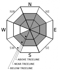
For 7000 ft. to 8000 ft.
Wednesday Wednesday Night Thursday
Weather: Cloudy with widespread snow showers in the morning. Snow showers decreasing in the afternoon. Partly cloudy with a chance of snow showers through the night. Sunny
Temperatures: 26 to 31 deg. F. 12 to 17 deg. F. 24 to 29 deg. F.
Mid Slope Winds: Southwest shifting to northwest in the afternoon North Northeast
Wind Speed: 20 to 35 mph with gusts to 70 mph decreasing to 15 to 20 mph with gusts to 45 mph in the afternoon 10 to 15 mph with gusts to 30 mph increasing to 50 mph after midnight. 15 to 25 mph with gusts 40 mph in the morning decreasing in the afternoon
Expected snowfall: 2 to 6 up to 1 0
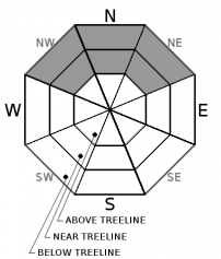
For 8000 ft. to 9000 ft.
Wednesday Wednesday Night Thursday
Weather: Cloudy with widespread snow showers in the morning. Snow showers decreasing in the afternoon. Partly cloudy with a chance of snow showers through the night. Sunny
Temperatures: 23 to 29 deg. F. 9 to 15 deg. F. 23 to 28 deg. F.
Ridge Top Winds: Southwest shifting to northwest in the afternoon North Northeast
Wind Speed: 40 to 60 mph with gusts to 110 mph decreasing to 20 to 30 mph with gusts to 55 mph in the afternoon 20 to 35 mph with gusts to 50 mph increasing to 75 mph after midnight 30 to 45 mph with gusts to 85 mph decreasing to 25 to 35 mph with gusts to 65 mph in the afternoon
Expected snowfall: 3 to 7 up to 1 0
Disclaimer

This avalanche advisory is provided through a partnership between the Tahoe National Forest and the Sierra Avalanche Center. This advisory covers the Central Sierra Nevada Mountains between Yuba Pass on the north and Ebbetts Pass on the south. Click here for a map of the forecast area. This advisory applies only to backcountry areas outside established ski area boundaries. This advisory describes general avalanche conditions and local variations always occur. This advisory expires 24 hours after the posted time unless otherwise noted. The information in this advisory is provided by the USDA Forest Service who is solely responsible for its content.

For a recorded version of the Avalanche Advisory call (530) 587-3558 x258