


For 7000 ft. to 8000 ft.
| Sunday | Sunday Night | Monday | |
|---|---|---|---|
| Weather: | Mostly cloudy | Mostly cloudy. Slight chance of snow in the evening. | Partly cloudy. |
| Temperatures: | 42 to 47 deg. F. | 27 to 32 deg. F. | 42 to 47 deg. F. |
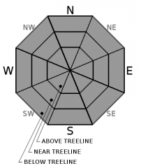
| Mid Slope Winds: | SW | SW | SW |
| Wind Speed: | 15 to 20mph. Gusts up to 30mph increasing to 40mph in the afternoon. | 15 to 20mph. Gusts up to 45mph, decreasing to 30mph after midnight. | Light winds becoming 10 to 15mph in the afternoon. Gusts up to 30mph. |
| Expected snowfall: | 0 | 0 | 0 |
For 8000 ft. to 9000 ft.
| Sunday | Sunday Night | Monday | |
|---|---|---|---|
| Weather: | Mostly cloudy. | Mostly cloudy. Slight chance of snow in the evening. | Partly cloudy. |
| Temperatures: | 39 to 45 deg. F. | 27 to 32 deg. F. | 39 to 44 deg. F. |
| Ridge Top Winds: | SW | SW | SW |
| Wind Speed: | 20 to 35mph with gusts to 60mph. | 20 to 35mph with gusts to 60mph. | 20 to 30mph with gusts to 55mph. |
| Expected snowfall: | 0 | 0 | 0 |


