THIS AVALANCHE FORECAST EXPIRED ON December 27, 2017 @ 6:49 am
Avalanche Forecast published on December 26, 2017 @ 6:49 am
Issued by Andy Anderson - Tahoe National Forest - Sierra Avalanche Center

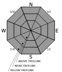
The avalanche danger remains LOW across the forecast area. Continue to use normal caution when traveling in the backcountry and watch for unstable snow on isolated terrain features especially in areas where small wind slabs exist on top of weaker snow. 

1. Low

?

Above Treeline
Generally safe avalanche conditions. Watch for unstable snow on isolated terrain features.

1. Low

?

Near Treeline
Generally safe avalanche conditions. Watch for unstable snow on isolated terrain features.

1. Low

?

Below Treeline
Generally safe avalanche conditions. Watch for unstable snow on isolated terrain features.
    Generally safe avalanche conditions. Watch for unstable snow on isolated terrain features.
Avalanche Problem 1: Normal Caution
  • Type ?
  • Aspect/Elevation ?
  • Likelihood ?
    Certain
    Very Likely
    Likely
    Possible
    Unlikely
  • Size ?
    Historic
    Very Large
    Large
    Small

Human triggered avalanches remain unlikely today. Unlikely does not mean impossible and some unstable snow may exist on some small isolated terrain features. Areas where small wind slabs rest on top of weak sugary snow represent the best places to find these lingering small isolated instabilities. Firm icy surfaces still exist on most near and above treeline slopes exposed to the wind. Northerly, lower angle, wind protected, below treeline slopes, still offer the best chances of finding soft winter snow. 

Early season conditions exist with numerous exposed and barely covered obstacles present in most places. Collisions with these hard immovable objects while sliding down an icy slope or getting carried by a small isolated patch of unstable wind slab or even just colliding with one of the obstacles while traveling across the snow could have serious consequences. Use normal caution and safe travel protocols when traveling in the backcountry. 

recent observations

* Variable snow surface conditions ranging from wind scoured snow and firm icy crusts on exposed slopes to some lingering areas of soft unconsolidated snow on sheltered below treeline northerly aspects exist.

* On Black Butte (near Carson Pass) yesterday, tests yielded unstable results and skier triggered whumphing occurred in areas where wind slabs sat on top of a layer of weak sugary snow. Pockets of terrain where this combination existed remained small and isolated with small shallow wind slabs

* Weak sugary snow still exists just below the surface and above the old rain crusts on many northerly aspects, but little to no slab layer exists above this weak layer in most places. 

* Northerly facing terrain above 8000 ft in the Mt. Rose area and along the Sierra Crest north of Emerald Bay holds the best snow coverage. Overall less snow cover exists south of Emerald Bay, but decent coverage exists above 8,500 ft. on northerly aspects. Coverage becomes patchy on other aspects and large areas of bare ground exist on many southerly aspects at all elevations.

Weather and CURRENT CONDITIONS
weather summary

Inversion conditions exist this morning with temperatures at the lower elevations about 10 degrees cooler than those at the upper elevations. Warmer air has started to move into the area and most of the sensors along ridgetops and in areas above 8000 ft. reported overnight lows in the upper 30's and low 40's. This warming trend should continue today with daytime highs above 7000 ft. in the upper 40's. Some high clouds may form over the region tonight and linger into tomorrow, but overall expect dry, mostly clear weather and above average temperatures through the week. 

CONDITIONS ALONG THE SIERRA CREST BETWEEN 8200 FT. AND 9200 FT. IN THE LAST 24 HOURS
6am temperature: 36 to 42 deg. F.
Max. temperature: 42 to 46 deg. F.
Average ridgetop wind direction: Variable between SW, N, and W
Average ridgetop wind speed: 10 to 15 mph
Maximum ridgetop wind gust: 51 mph
New snowfall: 0 inches
Total snow depth: 17 to 33 inches
Two-Day Mountain Weather Forecast Produced in partnership with the Reno NWS
For 7000 ft. to 8000 ft.
Tuesday Tuesday Night Wednesday
Weather: Sunny then becoming partly cloudy Partly cloudy Partly cloudy
Temperatures: 45 to 50 deg. F. 23 to 28 deg. F. 44 to 49 deg. F.
Mid Slope Winds: West Southwest Southwest
Wind Speed: 10 mph Light increasing to 10 to 15 mph with gusts to 30 mph after midnight 10 to 15 mph with gusts to 30 mph in the morning becoming light in the afternoon
Expected snowfall: 0 0 0
For 8000 ft. to 9000 ft.
Tuesday Tuesday Night Wednesday
Weather: Sunny then becoming partly cloudy Partly cloudy Partly cloudy
Temperatures: 42 to 47 deg. F. 24 to 29 deg. F. 40 to 45 deg. F.
Ridge Top Winds: West Southwest Southwest
Wind Speed: 15 to 25 mph with gusts to 40 mph 15 to 25 mph with gusts to 40 mph 20 to 30 mph with gusts to 50 mph
Expected snowfall: 0 0 0
Disclaimer

This avalanche advisory is provided through a partnership between the Tahoe National Forest and the Sierra Avalanche Center. This advisory covers the Central Sierra Nevada Mountains between Yuba Pass on the north and Ebbetts Pass on the south. Click here for a map of the forecast area. This advisory applies only to backcountry areas outside established ski area boundaries. This advisory describes general avalanche conditions and local variations always occur. This advisory expires 24 hours after the posted time unless otherwise noted. The information in this advisory is provided by the USDA Forest Service who is solely responsible for its content.

For a recorded version of the Avalanche Advisory call (530) 587-3558 x258