THIS AVALANCHE FORECAST EXPIRED ON December 28, 2017 @ 7:00 am
Avalanche Forecast published on December 27, 2017 @ 7:00 am
Issued by Andy Anderson - Tahoe National Forest - Sierra Avalanche Center

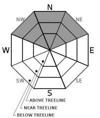
While avalanches remain unlikely in most areas, the avalanche danger has increased to MODERATE due to a stubborn persistent slab problem that exists in specific areas. Human triggered avalanches may be possible today in terrain where harder snow exists on top of a persistent weak layer of looser weaker snow. Evaluate snow and terrain carefully and identify areas where slabs may exist on top of a persistent weak layer

2. Moderate

?

Above Treeline
Heightened avalanche conditions on specific terrain features. Evaluate snow and terrain carefully; identify features of concern.

2. Moderate

?

Near Treeline
Heightened avalanche conditions on specific terrain features. Evaluate snow and terrain carefully; identify features of concern.

2. Moderate

?

Below Treeline
Heightened avalanche conditions on specific terrain features. Evaluate snow and terrain carefully; identify features of concern.
    Heightened avalanche conditions on specific terrain features. Evaluate snow and terrain carefully; identify features of concern.
Avalanche Problem 1: Persistent Slab
  • Type ?
  • Aspect/Elevation ?
  • Likelihood ?
    Certain
    Very Likely
    Likely
    Possible
    Unlikely
  • Size ?
    Historic
    Very Large
    Large
    Small

Despite the lack of new snow the snowpack continues to change as it sits on the ground. The layer of weak sugary snow (facetsbelow the surface continues to lose strength. In most places, little to no slab layer exists above this persistent weak layer and avalanches remain unlikely. However, in some specific areas where a slab layer does rest on top of the persistent weak layer, evidence indicates that the snowpack has lost enough strength for small human-triggered persistent slab avalanches to become possible. These areas include places on NW-N-NE aspects where hard wind slabs exist in near and above treeline terrain and some isolated areas in below treeline terrain where smaller softer slabs may exist. Persistent slabs avalanches can be triggered from the bottom of a slope or other connected slopes. They often break above the person who triggers them and may fail after several people have used a slope. They often do not fail until the trigger has fully committed to the slope. 

Clues like whumphing and collapsing, shooting cracks, hollow sounding snow, or digging into the snowpack to find a loose weak layer of snow below a harder layer of snow can indicate that conditions conducive to persistent slab avalanches may exist. Sometimes these clues may be difficult to find. Despite the fact that these kinds of avalanches should remain small, they could still have serious consequences in areas with terrain traps or if they carried a person into/over the numerous shallowly buried or exposed obstacles. Avoid steep slopes where slabs may exist on top of loose weak snow. Choosing sheltered terrain where no slabs exist will avoid this problem and provide softer snow to recreate on. 


recent observations

* Whumphing has occurred on Black Butte (near Carson Pass) and on Deep Creek Peak (north of Squaw) in the last 2 days as skiers caused the weak layer to collapse below a slab. Yesterday, tests yielded unstable results on Rubicon Peak as well in areas where hard wind slabs sat on top of a layer of weak sugary snow. 

* Variable snow surface conditions ranging from wind scoured snow and firm icy crusts on exposed slopes to some lingering areas of soft unconsolidated snow on sheltered below treeline northerly aspects exist.

* Northerly facing terrain above 8000 ft in the Mt. Rose area and along the Sierra Crest north of Emerald Bay holds the best snow coverage. Overall less snow cover exists south of Emerald Bay, but decent coverage exists above 8,500 ft. on northerly aspects. Coverage becomes patchy on other aspects and large areas of bare ground exist on many southerly aspects at all elevations.

Weather and CURRENT CONDITIONS
weather summary

Most of the remote sensors above 6500 ft. reported overnight lows above freezing. Warm weather should continue today and tomorrow with light to moderate SW winds. During the night the winds may shift towards the N before shifting back to the west tomorrow. Expect the dry warm weather to continue as long as the high-pressure ridge remains in place. 

CONDITIONS ALONG THE SIERRA CREST BETWEEN 8200 FT. AND 9200 FT. IN THE LAST 24 HOURS
6am temperature: 35 to 41 deg. F.
Max. temperature: 46 to 52 deg. F.
Average ridgetop wind direction: Southwest
Average ridgetop wind speed: 15 to 25 mph
Maximum ridgetop wind gust: 43 mph
New snowfall: 0 inches
Total snow depth: 17 to 33 inches
Two-Day Mountain Weather Forecast Produced in partnership with the Reno NWS
For 7000 ft. to 8000 ft.
Wednesday Wednesday Night Thursday
Weather: Partly cloudy Partly cloudy becoming clear Sunny
Temperatures: 45 to 50 deg. F. 23 to 28 deg. F. 49 to 54 deg. F.
Mid Slope Winds: Southwest Variable West
Wind Speed: 10 to 15 mph with gusts to 25 mph in the morning becoming light in the afternoon Light 10 to 20 mph with gusts to 30 mph
Expected snowfall: 0 0 0
For 8000 ft. to 9000 ft.
Wednesday Wednesday Night Thursday
Weather: Partly cloudy Partly cloudy becoming clear Sunny
Temperatures: 41 to 46 deg. F. 25 to 30 deg. F. 46 to 52 deg. F.
Ridge Top Winds: Southwest West shifting to the north after midnight West
Wind Speed: 15 to 25 mph with gusts to 45 mph 15 to 20 mph with gusts to 40 mph 15 to 25 mph with gusts to 35 mph in the morning increasing to 45 mph in the afternoon
Expected snowfall: 0 0 0
Disclaimer

This avalanche advisory is provided through a partnership between the Tahoe National Forest and the Sierra Avalanche Center. This advisory covers the Central Sierra Nevada Mountains between Yuba Pass on the north and Ebbetts Pass on the south. Click here for a map of the forecast area. This advisory applies only to backcountry areas outside established ski area boundaries. This advisory describes general avalanche conditions and local variations always occur. This advisory expires 24 hours after the posted time unless otherwise noted. The information in this advisory is provided by the USDA Forest Service who is solely responsible for its content.

For a recorded version of the Avalanche Advisory call (530) 587-3558 x258