THIS AVALANCHE FORECAST EXPIRED ON January 4, 2018 @ 6:52 am
Avalanche Forecast published on January 3, 2018 @ 6:52 am
Issued by Andy Anderson - Tahoe National Forest - Sierra Avalanche Center

Avalanche activity will remain unlikely in most areas today except in isolated areas where a slab layer exists above loose weak snow (facets) where small isolated human-triggered persistent slab avalanches may be possible. As a result, the avalanche danger remains at MODERATE at all elevations. As rain and snow begin to fall this evening some loose wet instabilities may start to form during the night and some of those isolated persistent slabs may become easier to trigger.

2. Moderate

?

Above Treeline
Heightened avalanche conditions on specific terrain features. Evaluate snow and terrain carefully; identify features of concern.

2. Moderate

?

Near Treeline
Heightened avalanche conditions on specific terrain features. Evaluate snow and terrain carefully; identify features of concern.

2. Moderate

?

Below Treeline
Heightened avalanche conditions on specific terrain features. Evaluate snow and terrain carefully; identify features of concern.
    Heightened avalanche conditions on specific terrain features. Evaluate snow and terrain carefully; identify features of concern.
Avalanche Problem 1: Persistent Slab
  • Type ?
  • Aspect/Elevation ?
  • Likelihood ?
    Certain
    Very Likely
    Likely
    Possible
    Unlikely
  • Size ?
    Historic
    Very Large
    Large
    Small

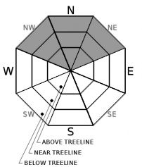
The prolonged dry period combined with a shallow snowpack has allowed a layer of loose weak sugary snow (facets) to form on northerly aspects across the forecast area. In most areas, no slab layer exists above this persistent weak layer. However, isolated slab layers do exist on some NW-N-NE aspects in the form of hard wind slabs in near and above treeline terrain and some softer slabs in below treeline terrain. Observations over the last week have indicated that in those isolated areas where the combination of persistent weak layer with a slab on top of it exists, the weak layer has weakened to the point that it can barely support the snow above it. Human triggered persistent slab avalanches may be possible in those areas today. Despite the light precipitation amounts associated with this storm, some of these isolated persistent slabs may become easier to trigger during the night as rain and snow add a bit more weight to the snowpack.

Signs that conditions conducive to persistent slab avalanches may exist include: human-triggered cracking, collapsing or whumpfing, a hollow sounding snowpack, feeling a softer weaker layer of snow below the surface with a probe or pole or hand pit, unstable snowpit tests, and any other signs that a slab may exist above weak faceted snow. Clues to instability may be difficult to find unless just the right combination of slab over weak layer exists, and an isolated human-triggered avalanche may represent the first clue to an unstable slope. Use safe travel protocols when traveling in and around avalanche terrain.  A shallow snowpack with numerous barely covered and still exposed obstacles would magnify the consequences of any size avalanche.

Avalanche Problem 2: Loose Wet
  • Type ?
  • Aspect/Elevation ?
  • Likelihood ?
    Certain
    Very Likely
    Likely
    Possible
    Unlikely
  • Size ?
    Historic
    Very Large
    Large
    Small

Loose wet avalanche activity will remain unlikely during the day today and will not represent an avalanche problem until it starts raining tonight. Once rain starts falling on the current snowpack during the night, loose wet avalanches will become possible in areas where soft snow exists on the snow surface. If for some reason a person has to travel in the backcountry during the night in an area where rain is falling on the snow, loose wet instabilities could be possible. 

recent observations

* Observations in the Carson Pass, Desolation Wilderness, West Shore Tahoe,  Deep Creek, Pole Creek, and Donner Summit areas during the last week continue to reveal signs of persistent slab instability including snow surface cracking, whumpfing, and/or unstable snowpit test results. This instability exists on NW-N-NE aspects in some isolated areas where loose sugary snow (facets) exists below either a hard or soft slab.

* Loose weak sugary snow (near surface facets) without an overlying slab is fairly widespread across the forecast area on northerly aspects in wind protected, below treeline areas.

* Snow surface conditions range from wind scoured snow and firm ice in near and above treeline terrain to lingering areas of soft unconsolidated snow on sheltered northerly aspects below treeline.

* Northerly aspects above 8000 ft in the Mt. Rose area and along the Sierra Crest north of Emerald Bay hold the best snow coverage at 2 to 3+ feet. Overall less snow cover exists south of Emerald Bay, but decent coverage exists above 8,500 ft. on northerly aspects in the Carson Pass area.  Coverage becomes patchy on other aspects with large areas of bare ground on many southerly aspects at all elevations.

Weather and CURRENT CONDITIONS
weather summary

Clouds have started to move into the region ahead of a warm weak storm that should arrive tonight. The forecast calls for this small system to bring increased south and southwest winds and up to .25 in. precipitation. Precipitation should start this evening with most of it falling after midnight. Due to the warm air traveling with this system expect snow levels to remain between 8000 and 8500 ft. allowing most of the precipitation to fall as rain in many areas. Areas above 8500 ft. may see up to 1-2 in. of snow accumulation by tomorrow morning with some of the higher elevations along the Sierra Crest possibly gaining up to 3 in. Scattered showers and unsettled weather should continue into the weekend. 

CONDITIONS ALONG THE SIERRA CREST BETWEEN 8200 FT. AND 9200 FT. IN THE LAST 24 HOURS
6am temperature: 38 to 44 deg. F.
Max. temperature: 46 to 48 deg. F.
Average ridgetop wind direction: South
Average ridgetop wind speed: 5 to 15 mph
Maximum ridgetop wind gust: 34 mph
New snowfall: 0 inches
Total snow depth: 16 to 32 inches
Two-Day Mountain Weather Forecast Produced in partnership with the Reno NWS
For 7000 ft. to 8000 ft.
Wednesday Wednesday Night Thursday
Weather: Mostly cloudy Cloudy with isolated rain showers in the evening precipitation becoming widespread after midnight. Snow levels between 8000 and 8500 ft. Mostly cloudy with scattered showers. Snow level 8000 ft.
Temperatures: 48 to 53 deg. F. 34 to 40 deg. F. 42 to 48 deg. F.
Mid Slope Winds: South South South
Wind Speed: 10 mph 10 mph 10 to 20 mph
Expected snowfall: 0 Rain: .1-.25 Rain: up to .1
For 8000 ft. to 9000 ft.
Wednesday Wednesday Night Thursday
Weather: Mostly cloudy Cloudy with isolated rain/snow showers in the evening. A mix of rain and snow becoming widespread after midnight. Snow level 8000 to 8500 ft. Mostly cloudy with scattered snow showers. Snow level 8000 ft.
Temperatures: 45 to 50 deg. F. 31 to 37 deg. F. 34 to 40 deg. F.
Ridge Top Winds: South South Southwest
Wind Speed: 15 to 25 mph with gusts to 35 mph 20 to 35 mph with gusts to 40 mph increasing to 65 mph after midnight 25 to 35 mph with gusts to 75 mph decreasing to 65 mph in the afternoon
Expected snowfall: 0 Rain: up to .25 in. | Snow: up to 1 up to 1
Disclaimer

This avalanche advisory is provided through a partnership between the Tahoe National Forest and the Sierra Avalanche Center. This advisory covers the Central Sierra Nevada Mountains between Yuba Pass on the north and Ebbetts Pass on the south. Click here for a map of the forecast area. This advisory applies only to backcountry areas outside established ski area boundaries. This advisory describes general avalanche conditions and local variations always occur. This advisory expires 24 hours after the posted time unless otherwise noted. The information in this advisory is provided by the USDA Forest Service who is solely responsible for its content.

For a recorded version of the Avalanche Advisory call (530) 587-3558 x258