THIS AVALANCHE FORECAST EXPIRED ON January 5, 2018 @ 6:59 am
Avalanche Forecast published on January 4, 2018 @ 6:59 am
Issued by Andy Anderson - Tahoe National Forest - Sierra Avalanche Center

MODERATE avalanche danger exists at all elevations today due to isolated persistent slabs in areas where a slab layer exists above loose weak snow and rain on snow creating loose wet instabilities. Human-triggered avalanches will be possible today. While most avalanches should remain small, the shallow snowpack and numerous exposed obstacles can provide large consequences for any size avalanche. Evaluate snow and terrain carefully. Identify where instabilities may exist and avoid those areas in favor of less steep slopes.

2. Moderate

?

Above Treeline
Heightened avalanche conditions on specific terrain features. Evaluate snow and terrain carefully; identify features of concern.

2. Moderate

?

Near Treeline
Heightened avalanche conditions on specific terrain features. Evaluate snow and terrain carefully; identify features of concern.

2. Moderate

?

Below Treeline
Heightened avalanche conditions on specific terrain features. Evaluate snow and terrain carefully; identify features of concern.
    Heightened avalanche conditions on specific terrain features. Evaluate snow and terrain carefully; identify features of concern.
Avalanche Problem 1: Persistent Slab
  • Type ?
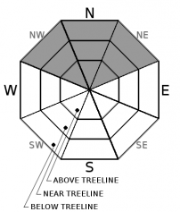
  • Aspect/Elevation ?
  • Likelihood ?
    Certain
    Very Likely
    Likely
    Possible
    Unlikely
  • Size ?
    Historic
    Very Large
    Large
    Small

A widespread layer of loose weak sugary snow (facets) exists on many northerly aspects across the forecast area. In most areas, little no slab layer exists above this persistent weak layer, but some isolated slab layers do exist above this weak layer on some NW-N-NE aspects. In near and above treeline terrain, a few hard wind slabs still linger above this layer. In below treeline terrain, some isolated softer slabs exist above the weak layer. Observations and data collected from those isolated areas where this combination of slab over weak layer exists indicate that the weak layer can barely support the snow above it. The additional weight of rain and snow from this storm may make these isolated persistent slabs easier to trigger today. Human triggered persistent slab avalanches remain possible today. Most of these persistent slabs should remain small, but they could still involve enough snow to cause problems for backcountry travelers.

Human-triggered cracking, collapsing or whumpfing, a hollow sounding snowpack, feeling a softer weaker layer of snow below the surface with a probe or pole or hand pit, unstable snowpit tests, and any other signs that a slab may exist above weak faceted snow may indicate that a persistent slab problem exists. Clues to instability may be difficult to find unless just the right combination of slab over weak layer exists, and an isolated human-triggered avalanche may represent the first clue to an unstable slope. Use safe travel protocols when traveling in and around avalanche terrain.  A shallow snowpack with numerous barely covered and still exposed obstacles would magnify the consequences of any size avalanche.

Avalanche Problem 2: Loose Wet
  • Type ?
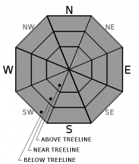
  • Aspect/Elevation ?
  • Likelihood ?
    Certain
    Very Likely
    Likely
    Possible
    Unlikely
  • Size ?
    Historic
    Very Large
    Large
    Small

Loose wet avalanches will be possible today. The northerly aspects below 8500 ft. where loose weak snow exists on the surface represent the most likely places for loose wet snow instabilities, but loose wet snow could form on any slopes where wet snow exists or on slopes that receive rain today. Today's wet snow instabilities could include pinwheels, roller balls, or point release avalanches. They may entrain enough snow to knock a person down or push them off course. Terrain traps and exposed obstacles could magnify the consequences of these loose wet avalanches.

recent observations

* Observations in the Carson Pass, Desolation Wilderness, West Shore Tahoe,  Deep Creek, Pole Creek, and Donner Summit areas during the last week continue to reveal signs of persistent slab instability including snow surface cracking, whumpfing, and/or unstable snowpit test results. This instability exists on NW-N-NE aspects in some isolated areas where loose sugary snow (facets) exists below either a hard or soft slab.

* Loose weak sugary snow (near surface facets) without an overlying slab is fairly widespread across the forecast area on northerly aspects in wind protected, below treeline areas.

* Snow surface conditions range from wind scoured snow and firm ice in near and above treeline terrain to lingering areas of soft unconsolidated snow on sheltered northerly aspects below treeline.

* Some areas of wet surface snow existed up to at least 8300 ft. yesterday near Grouse Rocks. 

* Northerly aspects above 8000 ft in the Mt. Rose area and along the Sierra Crest north of Emerald Bay hold the best snow coverage at 2 to 3+ feet. Overall less snow cover exists south of Emerald Bay, but decent coverage exists above 8,500 ft. on northerly aspects in the Carson Pass area.  Coverage becomes patchy on other aspects with large areas of bare ground on many southerly aspects at all elevations.

Weather and CURRENT CONDITIONS
weather summary

Precipitation started yesterday evening with snow levels around 9000 ft. and continued through the night. Snow levels stayed above 8000-8500 ft. in most areas. Snow level did briefly drop below 8000 ft. in some areas during the more intense periods of precipitation. So far .1 to .3 inches of liquid precipitation has fallen across the forecast area with most of this precip falling as rain below 8000-8500 ft. Above 8000-8500 ft. 1 to 2 inches of snow has accumulated. Scattered showers should continue today as light rain below 8000 ft. and light snow above 8000 ft. Another storm should move into the area tomorrow bringing more precipitation. The forecast calls for snow levels between 7500 and 8500 ft. tomorrow and tomorrow night. Expect the south and southwest winds to continue and to gain some speed through the next storm. 

CONDITIONS ALONG THE SIERRA CREST BETWEEN 8200 FT. AND 9200 FT. IN THE LAST 24 HOURS
6am temperature: 33 to 34 deg. F.
Max. temperature: 44 to 52 deg. F.
Average ridgetop wind direction: S and SW
Average ridgetop wind speed: 15 to 30 mph
Maximum ridgetop wind gust: 66 mph
New snowfall: Below 8000-8500 ft. - Rain: .1 to .3 inches | Above 8000-8500 ft. - Snow: 1 to 2 inches
Total snow depth: 17 to 33 inches
Two-Day Mountain Weather Forecast Produced in partnership with the Reno NWS
For 7000 ft. to 8000 ft.
Thursday Thursday Night Friday
Weather: Mostly cloudy with a chance of rain showers in the morning. Then scattered showers in the afternoon. Snow level 8500 ft. Mostly cloudy with scattered rain showers. Snow level 8000 ft. Mostly cloudy with scattered rain showers. Snow level 8000 ft.
Temperatures: 42 to 48 deg. F. 32 to 37 deg. F. 42 to 47 deg. F.
Mid Slope Winds: South South South
Wind Speed: 10 to 15 mph with gusts to 25 mph 10 to 15 mph with gusts to 30 mph increasing to 40 mph after midnight 15 to 25 mph with gusts to 40 mph
Expected snowfall: Rain up to .1 Rain up to .1 Rain up to .1
For 8000 ft. to 9000 ft.
Thursday Thursday Night Friday
Weather: Mostly cloudy with a chance of rain and snow in the morning. Isolated showers in the afternoon. Snow level 8500 ft. Mostly cloudy with isolated snow showers. Snow level 8000 ft. Mostly cloudy with scattered snow showers. Snow level 8000 ft.
Temperatures: 36 to 42 deg. F. 30 to 36 deg. F. 38 to 44 deg. F.
Ridge Top Winds: South South South
Wind Speed: 25 to 35 mph with gusts to 60 mph decreasing to 40 mph in the afternoon 20 to 30 mph with gusts to 55 mph increasing to 30 to 35 mph with gusts to 65 mph after midnight 30 to 45 mph with gusts to 70 mph
Expected snowfall: up to 2 Trace to 0 Trace to 0
Disclaimer

This avalanche advisory is provided through a partnership between the Tahoe National Forest and the Sierra Avalanche Center. This advisory covers the Central Sierra Nevada Mountains between Yuba Pass on the north and Ebbetts Pass on the south. Click here for a map of the forecast area. This advisory applies only to backcountry areas outside established ski area boundaries. This advisory describes general avalanche conditions and local variations always occur. This advisory expires 24 hours after the posted time unless otherwise noted. The information in this advisory is provided by the USDA Forest Service who is solely responsible for its content.

For a recorded version of the Avalanche Advisory call (530) 587-3558 x258