THIS AVALANCHE FORECAST EXPIRED ON January 10, 2018 @ 7:00 am
Avalanche Forecast published on January 9, 2018 @ 7:00 am
Issued by Andy Anderson - Tahoe National Forest - Sierra Avalanche Center

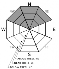
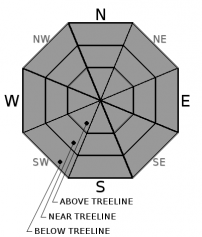
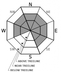
MODERATE avalanche danger exists below 9000 ft. and human triggered avalanches will remain possible today due to lingering persistent slabs, loose wet instabilities, and some wind slab problems. In areas above 9000 ft. where more of the precipitation fell as snow and in areas that received the most snow accumulation CONSIDERABLE danger exists and some human triggered wind slabs or persistent slabs may be likely. Careful snowpack evaluation, cautious route-finding and conservative decision-making are essential.

3. Considerable

?

Above Treeline
Dangerous avalanche conditions. Careful snowpack evaluation, cautious route-finding and conservative decision-making essential.

2. Moderate

?

Near Treeline
Heightened avalanche conditions on specific terrain features. Evaluate snow and terrain carefully; identify features of concern.

2. Moderate

?

Below Treeline
Heightened avalanche conditions on specific terrain features. Evaluate snow and terrain carefully; identify features of concern.
    Dangerous avalanche conditions. Careful snowpack evaluation, cautious route-finding and conservative decision-making essential.
Avalanche Problem 1: Persistent Slab
  • Type ?
  • Aspect/Elevation ?
  • Likelihood ?
    Certain
    Very Likely
    Likely
    Possible
    Unlikely
  • Size ?
    Historic
    Very Large
    Large
    Small

Widespread rain up to 8800 ft. over the last 24 hours should have soaked more of the old loose weak facet layers that exist on many northerly aspects. In those areas, while this layer of loose snow remains wet, it remains weak. Once it refreezes it will gain strength, but refreezing does not happen instantly and it may still be some time before this wet weak layer refreezes into a rain crust. At the upper elevations, this persistent weak layer may remain dry and loose and weak. Regardless of whether this layer is wet or dry it is barely able to support the snowpack currently resting above it. Human-triggered persistent slabs will remain possible today and some human triggered persistent slabs may be likely above 9000 ft. where more new snow has accumulated during the storm. Due to all the rain-soaked snow that may be sitting above these persistent slabs, they could entrain more wet snow and have some wet slab characteristics. The persistent slab avalanches could involve enough snow to bury a person.

Avoid steeper slopes in areas where snow surface cracking, whumpfing, and/or unstable snowpit test results are occurring. Quick hand pits remain an effective tool for seeing if a slab over weak loose snow exists. These kinds of avalanches can be triggered from connected slopes or may not release until a person has fully committed to the slope. 

Avalanche Problem 2: Loose Wet
  • Type ?
  • Aspect/Elevation ?
  • Likelihood ?
    Certain
    Very Likely
    Likely
    Possible
    Unlikely
  • Size ?
    Historic
    Very Large
    Large
    Small

Since much of the precipitation fell as rain during this storm, rain-soaked wet snow should exist on any slopes where snow coverage existed prior to this storm. Expect roller balls, pinwheels, and wet point release avalanches to remain possible until this rain-soaked snow starts to refreeze. Some of these could entrain enough snow to bury a person especially on northerly aspects where wet saturated snow exists.

Avoiding steep slopes where wet snow exists represents the easiest way to avoid loose wet avalanches.

Avalanche Problem 3: Wind Slab
  • Type ?
  • Aspect/Elevation ?
  • Likelihood ?
    Certain
    Very Likely
    Likely
    Possible
    Unlikely
  • Size ?
    Historic
    Very Large
    Large
    Small

Strong winds and some snow accumulation likely created new wind slabs on wind-loaded slopes during this storm. Most of these wind slabs should remain small at elevations below 8800 ft. since most of the precipitation fell as rain at those elevations. Above 9000 ft. in areas where more snow fell, larger wind slabs may exist. High elevation wind-loaded terrain along the Sierra Crest in the southern part of the forecast area holds the best potential for larger wind slabs. In isolated areas, wind slabs may be on top of old near surface facets on NW-N-NE aspects.

Look for cornice formation, blowing snow, and signs of previous blowing snow, especially along ridgelines and wind exposed areas. Use these clues to identify where wind slabs may exist and avoid those steep wind-loaded slopes. 

recent observations

* Human-triggered cracking and unstable snowpit test results occurred on Rubicon Peak yesterday, adding to the data of human-triggered cracking,  collapsing, whumpfing, and unstable test results that occurred on Red Lake Peak, near Woods Lake on Carson Pass, and in the Bear Valley area earlier this week. The weak loose facetted snow below the new snow represented the failure layer.

* In areas below 8200 ft. on Donner Summit yesterday observations showed snowpack with wet snow to the ground and tests did not yield unstable results. 

* Observations showed moist facets in some areas yesterday and dry facets in other areas. Whether they were dry or moist depended on elevation and on whether or not a slab existed above the facets. Regardless of whether they were moist or dry, they remained loose and weak.

* NW-N-NE aspects above 8,000' in the Mt. Rose area and along the Sierra Crest north of Emerald Bay hold the best snow coverage at 2 to 3+ feet. Overall less snow cover exists south of Emerald Bay. Areas of decent coverage exist above 8,500' on NW-N-NE aspects in the Carson Pass area.  Coverage decreases on all other aspects. Large areas of bare ground exist on the vast majority of southerly aspects at all elevations.

Weather and CURRENT CONDITIONS
weather summary

Snow levels have stayed between 8200 and 8800 ft. for most of the precipitation during this storm. Some sensors even indicated that snow levels climbed as high as 9500 ft. at the onset of the precipitation yesterday. As such, remote sensors along the Sierra Crest reported 1 to 3 inches of precipitation and only 2 to 5 inches of snow in between 8000 and 8800 ft. during the last 24 hours. Areas at the south end of the forecast region received the most precipitation. In the Mt. Rose area, less precipitation fell with sensors only reporting .6 inches of precipitation and 1 to 2 inches of snow. Above 9000 ft. snow totals should be dramatically higher and some of the highest elevations may have picked up significant amounts of snow overnight. The forecast now calls for this storm to shift farther south. Snow showers should continue today but with only 1 to 3 additional inches of snow accumulation. Some of this may still fall as rain since snow levels should remain around 8000 ft. today before falling into the 7500 and 7000 ft. range tonight and tomorrow. Showers should continue to diminish over the next 36 hours. The south wind should also decrease and shift towards the west and southwest today. The forecast calls for those west and southwest winds to increase tonight and tomorrow. 

CONDITIONS ALONG THE SIERRA CREST BETWEEN 8200 FT. AND 9200 FT. IN THE LAST 24 HOURS
6am temperature: 32 to 36 deg. F.
Max. temperature: 36 to 39 deg. F.
Average ridgetop wind direction: South and southwest
Average ridgetop wind speed: 30 mph
Maximum ridgetop wind gust: 56 mph
New snowfall: Rain 2.1 - 3.06 inches | Snow: 2 to 5 inches
Total snow depth: 20 to 39 inches
Two-Day Mountain Weather Forecast Produced in partnership with the Reno NWS
For 7000 ft. to 8000 ft.
Tuesday Tuesday Night Wednesday
Weather: Cloudy with snow and rain showers in the morning. Rain and snow showers likely in the afternoon. Snow level 8000 ft. Mostly cloudy with snow and rain showers likely in the evening. Rain and snow decreasing after midnight. Snow level 7500 ft. Mostly cloudy with a slight chance of snow showers. Snow level 7000 ft.
Temperatures: 38 to 43 deg. F. 25 to 30 deg. F. 39 to 44 deg. F.
Mid Slope Winds: Southeast West West
Wind Speed: 10 to 15 mph with gusts to 40 mph in the morning decreasing in the afternoon Light winds increasing to 10 to 15 mph with gusts to 35 mph after midnight. 10 to 15 mph with gusts to 40 mph
Expected snowfall: Rain: .1 to .25 in. | Snow up to 1 Rain: up to .1 in. | Snow: up to 1 0 to trace
For 8000 ft. to 9000 ft.
Tuesday Tuesday Night Wednesday
Weather: Cloudy with snow showers in the morning then snow showers likely in the afternoon. Snow level 8000 ft. Mostly cloudy with snow showers likely. Snow level 7500 ft. Mostly cloudy with a slight chance of snow showers. Snow level 7000 ft.
Temperatures: 35 to 40 deg. F. 23 to 28 deg. F. 35 to 40 deg. F.
Ridge Top Winds: South shifting to the southwest in the afternoon West West
Wind Speed: 20 to 30 mph with gusts to 55 mph decreasing to 10 to 15 mph with gusts to 25 mph in the afternoon 15 to 20 mph with gusts to 30 mph increasing to 20 to 30 mph with gusts to 50 mph after midnight 20 to 35 mph with gusts to 65 mph
Expected snowfall: 1 to 3 up to 1 0 to trace
Disclaimer

This avalanche advisory is provided through a partnership between the Tahoe National Forest and the Sierra Avalanche Center. This advisory covers the Central Sierra Nevada Mountains between Yuba Pass on the north and Ebbetts Pass on the south. Click here for a map of the forecast area. This advisory applies only to backcountry areas outside established ski area boundaries. This advisory describes general avalanche conditions and local variations always occur. This advisory expires 24 hours after the posted time unless otherwise noted. The information in this advisory is provided by the USDA Forest Service who is solely responsible for its content.

For a recorded version of the Avalanche Advisory call (530) 587-3558 x258