THIS AVALANCHE FORECAST EXPIRED ON January 14, 2018 @ 6:55 am
Avalanche Forecast published on January 13, 2018 @ 6:55 am
Issued by Brandon Schwartz - Tahoe National Forest

Avalanche danger is LOW for all elevations. While avalanche activity on a regional scale has become unlikely, human triggered persistent slab avalanches remain a concern in isolated areas.  Understanding if the avalanche problem does or does not exist within the snowpack on your terrain of interest should influence go/no go decision making much more than the regional scale danger rating.

1. Low

?

Above Treeline
Generally safe avalanche conditions. Watch for unstable snow on isolated terrain features.

1. Low

?

Near Treeline
Generally safe avalanche conditions. Watch for unstable snow on isolated terrain features.

1. Low

?

Below Treeline
Generally safe avalanche conditions. Watch for unstable snow on isolated terrain features.
    Generally safe avalanche conditions. Watch for unstable snow on isolated terrain features.
Avalanche Problem 1: Persistent Slab
  • Type ?
  • Aspect/Elevation ?
  • Likelihood ?
    Certain
    Very Likely
    Likely
    Possible
    Unlikely
  • Size ?
    Historic
    Very Large
    Large
    Small

Below treeline and near treeline terrain that is above 8,200' on NW-N-NE-E aspects is where any lingering persistent slab instability is most likely to exist. Avalanche size could reach D2. Faceted snow that formed in the snowpack during the December dry spell is the problem. This weak layer is generally found 6 inches to 2 feet below the snow surface. During the recent storms this layer became wet in some areas and remained dry to moist in other areas, especially near and above 9,000'. Ongoing unstable snowpit test results have been observed on both wet and dry facets. Wet facets have yet to fully refreeze. Open areas below treeline and near treeline with good protection from NE winds is where the facets had become weakest prior to the last round of storms. These same areas are the focus of lingering concern for this avalanche problem.

Keep in mind that triggering of a persistent slab avalanche could very well occur on the mid or lower portions of the slope, rather than near the top like a wind slab avalanche. Assessing the snowpack too high on the slope might cause one to miss important information.  Adjust data collection locations to meaningful areas for this specific avalanche problem, which will be different than the locally more common wind slab avalanche problem.

Avalanche Problem 2: Wind Slab
  • Type ?
  • Aspect/Elevation ?
  • Likelihood ?
    Certain
    Very Likely
    Likely
    Possible
    Unlikely
  • Size ?
    Historic
    Very Large
    Large
    Small

ENE winds last night may or may not have created some small wind slabs near and above treeline on SE-S-SW-W-NW aspects. This would have occurred through redistribution of snow on the ground. Complex terrain could have a patchwork of wind loaded and wind scoured areas on the same aspect.

Identify signs of recently wind drifted snow and the areas of potential new wind slab formation. Consider magnified consequences from down slope hazards such as rocks, trees, cliffs, or terrain traps before writing off hazard due to expected small avalanche size.

recent observations

* Snowpit data collected yesterday near Slab Cliffs (Mount Rose area) and on Castle Peak (Donner Summit area) indicated potential persistent slab instability in isolated areas.

* Observations made Thursday specifically targeting faceted snow layers of the persistent slab avalanche problem on Red lake Peak (Carson Pass area) and on Rubicon Peak and Peak 9,269' (West Shore Tahoe area) indicated improving strength of the snowpack in the areas traveled.

* NW-N-NE aspects above 8,000' in the Mt. Rose area and along the Sierra Crest north of Emerald Bay hold the best coverage at 2 to 4+ feet. Overall less snow cover exists south of Emerald Bay. Areas of decent coverage exist above 8,300' on NW-N-NE aspects in the Carson Pass area.  Coverage decreases dramatically on all other aspects.

Weather and CURRENT CONDITIONS
weather summary

High pressure over the forecast area will last into Monday. Moderate speed ridgetop winds out of the ENE this morning are expected to become light by this afternoon. Air temperature inversion conditions are in place. As a result, air temperatures on the mountain valley floors are below freezing this morning while at the same time air temperatures are above freezing at the mid and upper elevations. The next series of storm systems are forecast to begin impacting the region late Monday.

CONDITIONS ALONG THE SIERRA CREST BETWEEN 8200 FT. AND 9200 FT. IN THE LAST 24 HOURS
6am temperature: 33 to 38 deg. F.
Max. temperature: 42 to 50 deg. F.
Average ridgetop wind direction: ENE
Average ridgetop wind speed: 28 mph
Maximum ridgetop wind gust: 42 mph
New snowfall: 0 inches
Total snow depth: 21 to 38 inches
Two-Day Mountain Weather Forecast Produced in partnership with the Reno NWS
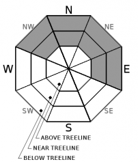
For 7000 ft. to 8000 ft.
Saturday Saturday Night Sunday
Weather: Sunny skies. Partly cloudy skies. Partly cloudy skies.
Temperatures: 46 to 51 deg. F. 31 to 36 deg. F. 50 to 55 deg. F.
Mid Slope Winds: ENE Variable Variable
Wind Speed: Generally light winds with gust up to 30 mph in the morning. Light winds Light winds
Expected snowfall: 0 0 0
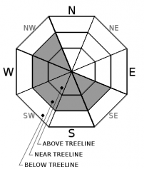
For 8000 ft. to 9000 ft.
Saturday Saturday Night Sunday
Weather: Sunny skies. Partly cloudy skies. Partly cloudy skies.
Temperatures: 44 to 49 deg. F. 33 to 39 deg. F. 47 to 52 deg. F.
Ridge Top Winds: ENE Variable Variable
Wind Speed: 10 to 15 mph with gusts to 35 mph in the morning, becoming light. Light winds Light winds
Expected snowfall: 0 0 0
Disclaimer

This avalanche advisory is provided through a partnership between the Tahoe National Forest and the Sierra Avalanche Center. This advisory covers the Central Sierra Nevada Mountains between Yuba Pass on the north and Ebbetts Pass on the south. Click here for a map of the forecast area. This advisory applies only to backcountry areas outside established ski area boundaries. This advisory describes general avalanche conditions and local variations always occur. This advisory expires 24 hours after the posted time unless otherwise noted. The information in this advisory is provided by the USDA Forest Service who is solely responsible for its content.

For a recorded version of the Avalanche Advisory call (530) 587-3558 x258