THIS AVALANCHE FORECAST EXPIRED ON January 16, 2018 @ 6:57 am
Avalanche Forecast published on January 15, 2018 @ 6:57 am
Issued by Andy Anderson - Tahoe National Forest - Sierra Avalanche Center

The avalanche danger remains LOW. Triggering an avalanche remains unlikely on a regional scale. LOW danger does not mean NO danger. Unstable snow may still exist in isolated areas due to lingering persistent slabs. Investigate the snowpack and determine if the persistent slab problem may still linger in your chosen area. If so or if you don't have enough data for a clear answer, chose a different area. Avalanche danger should increase tomorrow as a small storm impacts the area.

1. Low

?

Above Treeline
Generally safe avalanche conditions. Watch for unstable snow on isolated terrain features.

1. Low

?

Near Treeline
Generally safe avalanche conditions. Watch for unstable snow on isolated terrain features.

1. Low

?

Below Treeline
Generally safe avalanche conditions. Watch for unstable snow on isolated terrain features.
    Generally safe avalanche conditions. Watch for unstable snow on isolated terrain features.
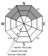
Avalanche Problem 1: Persistent Slab
  • Type ?
  • Aspect/Elevation ?
  • Likelihood ?
    Certain
    Very Likely
    Likely
    Possible
    Unlikely
  • Size ?
    Historic
    Very Large
    Large
    Small

Persistent weak layers take time to heal, and as they do, they stabilize in some places and linger in others. In most areas triggering a persistent slab avalanche has become unlikely because the persistent weak layer has either become wet and mostly refrozen or it has become denser and adjusted to the weight of the current snowpack above it. Despite the trend toward gaining strength, this layer still lingers on some NW-N-NE aspects and triggering a persistent slab avalanche is not impossible on some isolated terrain features. Open slopes sheltered from this winter's NE winds at elevations above 8000 ft. represent the best places to find lingering instability. More complex terrain like sheltered, shady couloirs, steep rocky slopes, or slopes with steep convex roll-overs where the persistent weak layer remains weak could also be suspect. As more snow and rain impact the forecast area this week, the persistent weak layer could reactivate and persistent slabs could become a more widespread avalanche problem.

Tools like quick snowpit tests, handpits, and probing can help identify those isolated areas where the persistent weak layer may still exist. Avoiding those isolated areas where instability may linger and slopes connected to those areas still remains a prudent choice. If one of these isolated areas were to release, it could release above the person who triggers it and it may not release until that trigger fully commits to the slope. This weak layer is more likely to exist in the mid to lower part of a slope and so evaluating the slope from the traditional start zone at the top of a slope may not provide a meaningful or accurate assessment. 

recent observations

* Snowpit tests from Tamarack Peak yesterday yielded mixed results in an area where tests from 4 days ago yielded consistent unstable results. Recently other data and observations from the Elephants Back area (Carson Pass area), Castle Peak (Donner Summit area), and Slab Cliffs (Mount Rose area) indicated persistent slab instability may still linger in some isolated areas. 

* Observations earlier this week targeting the persistent weak layer of loose weak snow on Red Lake Peak (Carson Pass area) and on Rubicon Peak and Peak 9,269' (West Shore Tahoe area) indicated that this layer and the overall snowpack continue to gain strength.

* No human triggered persistent slab avalanches have been reported. 

* NW-N-NE aspects above 8,000' in the Mt. Rose area and along the Sierra Crest north of Emerald Bay hold the best coverage at 2 to 4+ feet. Overall less snow cover exists south of Emerald Bay. Areas of decent coverage exist above 8,300' on NW-N-NE aspects in the Carson Pass area.  Coverage decreases dramatically on all other aspects.

Weather and CURRENT CONDITIONS
weather summary

Expect more warm dry weather today as the high-pressure ridge lingers over the region. A small fast storm approaching the area should cause the south and southwest winds to increase today and they should peak during the day tomorrow. Cloud cover should also become more widespread during the day today. The forecast calls for this fast-moving storm to arrive tonight and linger through tomorrow. Precipitation should begin sometime during the night with snow levels starting near 8000 ft. and dropping to 7000 to 7500 ft. by tomorrow morning. Upper elevations along the Sierra Crest could receive 2 to 6 inches of new snow by the end of the storm tomorrow depending on snow levels and how fast this storm moves through the region. Areas between 7000 and 8000 ft. may see a mix of rain and snow. The precipitation should fall mostly as rain below 7000 ft.

CONDITIONS ALONG THE SIERRA CREST BETWEEN 8200 FT. AND 9200 FT. IN THE LAST 24 HOURS
6am temperature: 34 to 41 deg. F.
Max. temperature: 48 to 50 deg. F.
Average ridgetop wind direction: South and southwest
Average ridgetop wind speed: 20 mph
Maximum ridgetop wind gust: 40 mph
New snowfall: 0 inches
Total snow depth: 21 to 38 inches
Two-Day Mountain Weather Forecast Produced in partnership with the Reno NWS
For 7000 ft. to 8000 ft.
Monday Monday Night Tuesday
Weather: Mostly cloudy Mostly cloudy with a chance of rain through the night and a chance of a mix of rain and snow after midnight. Snow level 8000 ft. Mostly cloudy with a mix of rain and snow likely. Snow level 7500 ft.
Temperatures: 47 to 52 deg. F. 31 to 36 deg. F. 39 to 44 deg. F.
Mid Slope Winds: South South Southwest
Wind Speed: Light in the morning increasing to 10 to 15 mph with gusts to 40 mph in the afternoon 10 to 15 mph with gusts to 45 mph 15 to 25 mph with gusts to 50 mph
Expected snowfall: 0 Rain: up to .1 in. | Snow: up to 1 Rain: .15 to .25 in. | Snow: 1 to 4
For 8000 ft. to 9000 ft.
Monday Monday Night Tuesday
Weather: Mostly cloudy Mostly cloudy with a chance of snow especially after midnight. Snow level 8000 ft. Mostly cloudy with snow likely. Snow level 7500 ft.
Temperatures: 44 to 49 deg. F. 29 to 34 deg. F. 35 to 41 deg. F.
Ridge Top Winds: South South Southwest
Wind Speed: 20 to 30 mph with gusts to 60 mph 20 to 35 mph with gusts to 60 mph 25 to 35 mph increasing to 30 to 45 mph with gusts to 70 mph in the afternoon
Expected snowfall: 0 up to 2 1 to 4
Disclaimer

This avalanche advisory is provided through a partnership between the Tahoe National Forest and the Sierra Avalanche Center. This advisory covers the Central Sierra Nevada Mountains between Yuba Pass on the north and Ebbetts Pass on the south. Click here for a map of the forecast area. This advisory applies only to backcountry areas outside established ski area boundaries. This advisory describes general avalanche conditions and local variations always occur. This advisory expires 24 hours after the posted time unless otherwise noted. The information in this advisory is provided by the USDA Forest Service who is solely responsible for its content.

For a recorded version of the Avalanche Advisory call (530) 587-3558 x258