THIS AVALANCHE FORECAST EXPIRED ON January 24, 2018 @ 6:54 am
Avalanche Forecast published on January 23, 2018 @ 6:54 am
Issued by Andy Anderson - Tahoe National Forest - Sierra Avalanche Center

LOW avalanche danger exists at all elevations, but LOW danger does not mean no danger. An isolated persistent slab avalanche problem may still linger in a few areas. In the unlikely event that an isolated human-triggered persistent slab avalanche does occur, it could be large with significant consequences.

1. Low

?

Above Treeline
Generally safe avalanche conditions. Watch for unstable snow on isolated terrain features.

1. Low

?

Near Treeline
Generally safe avalanche conditions. Watch for unstable snow on isolated terrain features.

1. Low

?

Below Treeline
Generally safe avalanche conditions. Watch for unstable snow on isolated terrain features.
    Generally safe avalanche conditions. Watch for unstable snow on isolated terrain features.
Avalanche Problem 1: Persistent Slab
  • Type ?
  • Aspect/Elevation ?
  • Likelihood ?
    Certain
    Very Likely
    Likely
    Possible
    Unlikely
  • Size ?
    Historic
    Very Large
    Large
    Small

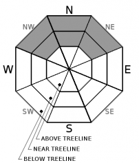
Triggering a persistent slab avalanche has become unlikely in most areas. However, recent unstable snowpit tests indicate that persistent slabs are not impossible on some isolated near and below treeline NW-N-NE aspects sheltered from previous NE winds. If a person could find just the right spot on one of these isolated slopes to trigger one of these difficult to trigger (stubborn) persistent slabs, the resulting avalanche could be large (up to D2 or D3) and destructive. Which isolated slopes may still hold a persistent slab avalanche problem is subject to significant uncertainty and variability with no clear explanation for the variations in stability across similar terrain.

Due to the uncertainty, variability, and potential high consequences of this difficult to trigger (low probability) avalanche problem, avoiding terrain where persistent slabs may exist still represents a prudent choice. Collapsing and whumpfing, unstable snowpit test results, and handpits/probing into the snowpack to feel for a loose layer of weak snow under firm slab layers can help identify where persistent slab problems may still exist. This persistent slab problem is more likely in the mid to lower portions of the slope than at the traditional starting zone near the top of a slope.

recent observations

* Since the last storm some snowpit tests on some near and below treeline NW-N-NE aspects in the Mt. Rose backcountry, the Carson Pass area, and the Donner Pass area have indicated that while a persistent slab may be difficult to trigger if the weak layer does break the fracture could still travel through it. Other tests from these places and other areas around the forecast area did not reveal any signs of instability associated with the persistent weak layer and snowpit tests indicated a well-consolidated snowpack.

* Ski cuts yesterday afternoon on a small E and NE facing wind-loaded test slopes on Andesite Peak produced some minor cracking but no wind slab failures. 

* Snowpit observations from Andesite Peak revealed a layer of buried surface hoar under the new snow in sheltered areas.

* A mix of rain and snow occurred up to at least 8200 ft. in some areas yesterday, leaving a thin rain crust on the snow surface.

Weather and CURRENT CONDITIONS
weather summary

A small ridge of high pressure should keep today mostly sunny with light winds and slightly warmer temperatures. By tonight the cloud cover and wind should begin to increase as a winter storm approaches the area. The winds will continue to increase through tomorrow with the forecast calling for strong to gale force SW winds by tomorrow evening. Precipitation should begin sometime tomorrow with some light (up to 1 inch) accumulation possible. The forecast calls for the bulk of the storm to arrive tomorrow night. Check in with the Reno NWS for more details.  

CONDITIONS ALONG THE SIERRA CREST BETWEEN 8200 FT. AND 9200 FT. IN THE LAST 24 HOURS
6am temperature: 19 to 32 deg. F.
Max. temperature: 31 to 34 deg. F.
Average ridgetop wind direction: Southwest
Average ridgetop wind speed: 10 to 20 mph
Maximum ridgetop wind gust: 60 mph
New snowfall: trace to 2 inches
Total snow depth: 25 to 47 inches
Two-Day Mountain Weather Forecast Produced in partnership with the Reno NWS
For 7000 ft. to 8000 ft.
Tuesday Tuesday Night Wednesday
Weather: Sunny with some clouds developing during the day Partly cloudy Mostly cloudy with a slight chance of snow in the afternoon
Temperatures: 40 to 45 deg. F. 25 to 30 deg. F. 40 to 45 deg. F.
Mid Slope Winds: Variable Southwest Southwest
Wind Speed: Light 10 to 15 mph with gusts to 30 mph increasing to 45 mph after midnight 20 to 30 mph with gusts to 65 mph increasing to 30 to 45 mph with gusts to 80 mph in the afternoon
Expected snowfall: 0 0 up to 1
For 8000 ft. to 9000 ft.
Tuesday Tuesday Night Wednesday
Weather: Sunny with some clouds developing during the day Partly cloudy Mostly cloudy with a slight chance of snow in the afternoon
Temperatures: 37 to 42 deg. F. 24 to 29 deg. F. 34 to 40 deg. F.
Ridge Top Winds: Southwest Southwest shifting to the south after midnight Southwest
Wind Speed: 10 to 15 mph with gusts to 30 mph 15 to 25 mph with gusts to 45 mph increasing to 20 to 35 mph with gusts to 70 mph 35 to 55 mph with gusts to 100 mph increasing to 45 to 65 mph with gusts to 110 mph in the afternoon
Expected snowfall: 0 0 up to 1
Disclaimer

This avalanche advisory is provided through a partnership between the Tahoe National Forest and the Sierra Avalanche Center. This advisory covers the Central Sierra Nevada Mountains between Yuba Pass on the north and Ebbetts Pass on the south. Click here for a map of the forecast area. This advisory applies only to backcountry areas outside established ski area boundaries. This advisory describes general avalanche conditions and local variations always occur. This advisory expires 24 hours after the posted time unless otherwise noted. The information in this advisory is provided by the USDA Forest Service who is solely responsible for its content.

For a recorded version of the Avalanche Advisory call (530) 587-3558 x258