THIS AVALANCHE FORECAST EXPIRED ON January 29, 2018 @ 7:00 am
Avalanche Forecast published on January 28, 2018 @ 7:00 am
Issued by Andy Anderson - Tahoe National Forest - Sierra Avalanche Center

The avalanche danger remains MODERATE due to old and new wind slabs in near and above treeline terrain. Some loose wet avalanches may become possible as the day warms up.  Unlikely but not impossible persistent slabs may also linger in below treeline areas, especially in the Carson Pass region. 

2. Moderate

?

Above Treeline
Heightened avalanche conditions on specific terrain features. Evaluate snow and terrain carefully; identify features of concern.

2. Moderate

?

Near Treeline
Heightened avalanche conditions on specific terrain features. Evaluate snow and terrain carefully; identify features of concern.

2. Moderate

?

Below Treeline
Heightened avalanche conditions on specific terrain features. Evaluate snow and terrain carefully; identify features of concern.
    Heightened avalanche conditions on specific terrain features. Evaluate snow and terrain carefully; identify features of concern.
Avalanche Problem 1: Wind Slab
  • Type ?
  • Aspect/Elevation ?
  • Likelihood ?
    Certain
    Very Likely
    Likely
    Possible
    Unlikely
  • Size ?
    Historic
    Very Large
    Large
    Small

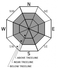
The E and NE winds yesterday afternoon and evening may have grown strong enough to form small wind slabs near ridgelines on some S-SW-W aspects. In addition to these new wind slabs, older, larger, and still potentially unstable wind slabs could linger on near and above treeline N-NE-E aspects loaded by previous SW winds. Wind slabs could also exist on NW and SE aspects where either wind direction could cross-load the slope. Avalanches resulting from the failure of these wind slabs could involve enough snow to bury or injure a person (size D2).

Human triggered wind slabs avalanches are still possible today. Use clues like wind drifted snow, cornices above slopes, wind pillows, and wind-sculpted snow surfaces to identify and avoid areas of potentially unstable wind slabs.


Avalanche Problem 2: Loose Wet
  • Type ?
  • Aspect/Elevation ?
  • Likelihood ?
    Certain
    Very Likely
    Likely
    Possible
    Unlikely
  • Size ?
    Historic
    Very Large
    Large
    Small

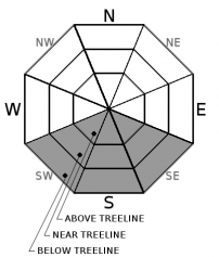
Today's warm sunny weather could cause enough warming and melting for loose wet avalanches to become possible on steep sun-exposed SE-S-SW aspects. This loose wet avalanche problem could take the form of roller balls, pinwheels, or point release avalanches. Most of these should not entrain enough snow to bury a person, but they could knock a person over or push a person into terrain where collisions or a fall would have serious consequences. 

Avalanche Problem 3: Persistent Slab
  • Type ?
  • Aspect/Elevation ?
  • Likelihood ?
    Certain
    Very Likely
    Likely
    Possible
    Unlikely
  • Size ?
    Historic
    Very Large
    Large
    Small

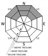
Snowpit tests and a recent avalanche with persistent slab characteristics indicates that a persistent slab problem may still linger on some NW-N-NE facing slopes in the Carson Pass area. A layer of loose weak snow near a crust 8 to 12 inches below the surface represents the persistent weak layer for this problem. Observations from Crater Lake, Meiss Meadows, Elephants Hump, and Squaw Ridge prior to last week's storms showed the existence of this weak layer. Uncertainty still remains as to whether or not this weak layer remains widespread or how it has reacted to the new snow due to a limited amount of data targetting this layer. If this problem does exist it will linger in near and below treeline areas on NW-N-NE aspects and mainly be focused in the Carson Pass area. Persistent slab avalanches could involve enough snow to bury or injure a person if they do occur (size D2 with some potential for an isolated D3).

Look for and avoid avalanche terrain in any areas where snow surface cracking, snowpack collapse with a possible whumpfing sound, and/or unstable snowpit test results are occurring.

Concern for this avalanche problem continues to decrease on a regional scale as the deeply buried facet layer from December and the now unreactive buried surface hoar are no longer the main focus of this avalanche problem. Concern remains elevated for the Carson Pass area and for any yet to be observed areas where this same near crust facet layer exists.

recent observations

* A skier triggered avalanche about 60 ft. wide and 1 ft. deep was reported on the N side of Castle Peak on a NE facing above treeline slope in typically wind loaded terrain yesterday. It broke around the skier who triggered it and carried the skier about 150 ft. downslope but did not bury the skier. Other wind slab avalanches were reported on Friday in the Bronco Chutes of Relay Peak (Mount Rose area), Thursday from the Far East Ridge of Tamarack Peak (Mount Rose area), and from the south end of Andesite Ridge (Donner Summit area). 

* Ski cuts on recently wind-loaded slopes along Chickadee Ridge (Mount Rose backcountry) and snowmobile cuts on wind-loaded test slopes near Blue Lakes (Carson Pass area) both produced shooting cracks yesterday indicating lingering wind slab instability. 

* Warming surface snow was reported on sun-exposed slopes of Carpenter Peak (near Independence Lake) and some roller balls started to occur near rocks on SE facing slopes near Blue Lakes (Carson Pass area) yesterday afternoon.

* Snowmobilers reported a recent avalanche on the Nipple (in the Blue Lakes area) that likely failed on the persistent weak layer of facets near a crust and was likely triggered by a nearby loose dry sluff. Snowpit tests targetting that persistent weak layer of facets buried about 8 to 12 inches below the surface near a crust still produced unstable results on N aspects near Lost Lakes (Carson Pass area) yesterday. A skier on Waterhouse Peak (Luther Pass area) also reported a facet layer at a similar depth.

Weather and CURRENT CONDITIONS
weather summary

Yesterday the east and northeast wind picked up in the afternoon and evening before decreasing some overnight. These winds should remain mostly light through tonight with some lingering gusts in the 25 to 35 mph range today. By tomorrow the wind should shift back to the south and southwest and start to increase. The forecast calls for mostly clear and warm days for the foreseeable future due to a strong high-pressure ridge parked over the area.  

CONDITIONS ALONG THE SIERRA CREST BETWEEN 8200 FT. AND 9200 FT. IN THE LAST 24 HOURS
6am temperature: 32 to 40 deg. F.
Max. temperature: 38 to 43 deg. F.
Average ridgetop wind direction: E and NE
Average ridgetop wind speed: 15 to 25 mph
Maximum ridgetop wind gust: 49 mph
New snowfall: 0 inches
Total snow depth: 31 to 57 inches
Two-Day Mountain Weather Forecast Produced in partnership with the Reno NWS
For 7000 ft. to 8000 ft.
Sunday Sunday Night Monday
Weather: Sunny Partly cloudy Mostly cloudy
Temperatures: 47 to 52 deg. F. 30 to 35 deg. F. 48 to 53 deg. F.
Mid Slope Winds: Variable Variable Variable
Wind Speed: Light with some gusts of 20 to 25 mph Light Light
Expected snowfall: 0 0 0
For 8000 ft. to 9000 ft.
Sunday Sunday Night Monday
Weather: Sunny Partly cloudy Mostly cloudy
Temperatures: 43 to 48 deg. F. 31 to 36 deg. F. 45 to 50 deg. F.
Ridge Top Winds: Variable Variable Southwest
Wind Speed: Light with some gusts of 25 to 30 mph Light 15 to 20 mph with gusts to 35 mph in the afternoon
Expected snowfall: 0 0 0
Disclaimer

This avalanche advisory is provided through a partnership between the Tahoe National Forest and the Sierra Avalanche Center. This advisory covers the Central Sierra Nevada Mountains between Yuba Pass on the north and Ebbetts Pass on the south. Click here for a map of the forecast area. This advisory applies only to backcountry areas outside established ski area boundaries. This advisory describes general avalanche conditions and local variations always occur. This advisory expires 24 hours after the posted time unless otherwise noted. The information in this advisory is provided by the USDA Forest Service who is solely responsible for its content.

For a recorded version of the Avalanche Advisory call (530) 587-3558 x258