


For 7000 ft. to 8000 ft.
| Tuesday | Tuesday Night | Wednesday | |
|---|---|---|---|
| Weather: | Partly cloudy to mostly sunny | Partly cloudy to mostly clear | Partly cloudy to mostly sunny |
| Temperatures: | 50 to 55 deg. F. | 27 to 32 deg. F. | 49 to 54 deg. F. |
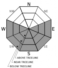
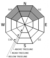
| Mid Slope Winds: | Southwest | Southwest | West |
| Wind Speed: | 10 to 20 mph with gusts to 40 mph | 10 to 20 mph with gusts to 40 mph decreasing to 30 mph after midnight | 10 to 15 mph with gusts to 30 mph becoming light in the afternoon |
| Expected snowfall: | 0 | 0 | 0 |
For 8000 ft. to 9000 ft.
| Tuesday | Tuesday Night | Wednesday | |
|---|---|---|---|
| Weather: | Partly cloudy to mostly sunny | Partly cloudy to mostly clear | Partly cloudy to mostly sunny |
| Temperatures: | 45 to 51 deg. F. | 27 to 32 deg. F. | 45 to 51 deg. F. |
| Ridge Top Winds: | Southwest | West | West |
| Wind Speed: | 20 to 30 mph with gusts to 60 mph | 20 to 30 mph with gusts to 60 mph decreasing to 45 mph after midnight | 20 to 30 mph with gusts to 50 mph decreasing to 15 to 20 mph with gusts to 40 mph in the afternoon |
| Expected snowfall: | 0 | 0 | 0 |


