THIS AVALANCHE FORECAST EXPIRED ON February 3, 2018 @ 6:55 am
Avalanche Forecast published on February 2, 2018 @ 6:55 am
Issued by Brandon Schwartz - Tahoe National Forest

Avalanche danger is LOW for all elevations. Isolated areas of unstable snow will form today. Loose wet is the avalanche problem to look for and avoid. Slab avalanches are very unlikely today on a regional scale.

1. Low

?

Above Treeline
Generally safe avalanche conditions. Watch for unstable snow on isolated terrain features.

1. Low

?

Near Treeline
Generally safe avalanche conditions. Watch for unstable snow on isolated terrain features.

1. Low

?

Below Treeline
Generally safe avalanche conditions. Watch for unstable snow on isolated terrain features.
    Generally safe avalanche conditions. Watch for unstable snow on isolated terrain features.
Avalanche Problem 1: Loose Wet
  • Type ?
  • Aspect/Elevation ?
  • Likelihood ?
    Certain
    Very Likely
    Likely
    Possible
    Unlikely
  • Size ?
    Historic
    Very Large
    Large
    Small

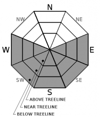
Most wet snow instability today will present in the form of roller balls and pinwheels. Loose wet avalanches of size D1 (too small to bury a person) could be human triggered in isolated areas of steep terrain. This avalanche problem is most likely on E-SE aspects where a combination of full sun exposure and continuous snow cover exists. This problem is less likely on S-SW-W aspects due to thin patchy snow cover in many areas, but still warrants consideration.

recent observations

* Observations received yesterday from along the Sierra Crest between Pole Creek and Deep Creek reported wet surface snow with some skier triggered loose wet avalanches on steep SE aspects. Avalanche size was not reported. Extremely thin snow cover was reported on S-SW-W aspects in this area. Signs of numerous wind slab avalanches from last week were visible in this area on NE-E aspects near and above treeline.

* Observations made yesterday on Mt. Lola (Independence Lake area) reported around 1 inch of surface wet snow on NW aspects below 8,400' and on E-SE-S aspects up to the highpoint of travel at 8,780'. Snowpit tests targeting potential weak layers within the top three feet of the snowpack on a NW aspect at 8,400' revealed no signs of instability.

* Expect a mix of breakable and supportable crusts to have formed in the majority of areas last night. Only the most heavily shaded upper elevation NW-N-NE aspect terrain will have surface snow that has yet to be affected by melt-freeze.

Weather and CURRENT CONDITIONS
weather summary

High pressure over the forecast area will allow for sunny skies for the next few days. Air temperature inversion conditions have air temperatures above freezing at the mid and upper elevations this morning. Areas of below freezing air temperatures are limited to locations on the mountain valley floors. Maximum daytime air temperatures are forecast to reach 15 to 20 degrees above average for this time of year. Light ridgetop winds today are expected to increase to moderate in speed out of the NE for tonight and tomorrow.

CONDITIONS ALONG THE SIERRA CREST BETWEEN 8200 FT. AND 9200 FT. IN THE LAST 24 HOURS
6am temperature: 35 to 40 deg. F.
Max. temperature: 42 to 53 deg. F.
Average ridgetop wind direction: NE
Average ridgetop wind speed: 22 mph
Maximum ridgetop wind gust: 40 mph
New snowfall: 0 inches
Total snow depth: 28 to 52 inches
Two-Day Mountain Weather Forecast Produced in partnership with the Reno NWS
For 7000 ft. to 8000 ft.
Friday Friday Night Saturday
Weather: Sunny skies. Clear skies. Sunny skies.
Temperatures: 51 to 56 deg. F. 30 to 35 deg. F. 52 to 57 deg. F.
Mid Slope Winds: NE NE N
Wind Speed: Light winds Light winds Around 10 mph.
Expected snowfall: 0 0 0
For 8000 ft. to 9000 ft.
Friday Friday Night Saturday
Weather: Sunny skies. Clear skies. Sunny skies.
Temperatures: 48 to 53 deg. F. 31 to 36 deg. F. 49 to 54 deg. F.
Ridge Top Winds: NE NE NE
Wind Speed: Light winds becoming around 10 mph in the afternoon. 15 to 25 mph with gusts up to 35 mph. 15 to 25 mph with gusts up to 40 mph.
Expected snowfall: 0 0 0
Disclaimer

This avalanche advisory is provided through a partnership between the Tahoe National Forest and the Sierra Avalanche Center. This advisory covers the Central Sierra Nevada Mountains between Yuba Pass on the north and Ebbetts Pass on the south. Click here for a map of the forecast area. This advisory applies only to backcountry areas outside established ski area boundaries. This advisory describes general avalanche conditions and local variations always occur. This advisory expires 24 hours after the posted time unless otherwise noted. The information in this advisory is provided by the USDA Forest Service who is solely responsible for its content.

For a recorded version of the Avalanche Advisory call (530) 587-3558 x258