THIS AVALANCHE FORECAST EXPIRED ON February 18, 2018 @ 6:48 am
Avalanche Forecast published on February 17, 2018 @ 6:48 am
Issued by Brandon Schwartz - Tahoe National Forest

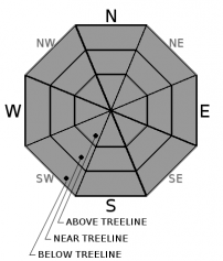
LOW avalanche danger continues for all elevations within the forecast area. Normal caution is advised. Avalanche danger may increase Sunday evening.

1. Low

?

Above Treeline
Generally safe avalanche conditions. Watch for unstable snow on isolated terrain features.

1. Low

?

Near Treeline
Generally safe avalanche conditions. Watch for unstable snow on isolated terrain features.

1. Low

?

Below Treeline
Generally safe avalanche conditions. Watch for unstable snow on isolated terrain features.
    Generally safe avalanche conditions. Watch for unstable snow on isolated terrain features.
Avalanche Problem 1: Normal Caution
  • Type ?
  • Aspect/Elevation ?
  • Likelihood ?
    Certain
    Very Likely
    Likely
    Possible
    Unlikely
  • Size ?
    Historic
    Very Large
    Large
    Small

No specific avalanche problems of concern exist within the forecast area at this time. Keep an eye out for the unlikely presence of a small, isolated wind slab within the generally wind scoured areas near and above treeline.

Above freezing air temperatures today will create some areas of snow surface melt. Loose wet avalanche problems remain very unlikely due to the current snowpack structure and distribution in areas of direct sun exposure.

Firm wind scoured surfaces and crusts exist in most near and above treeline areas and could pose a travel hazard in steep terrain.

recent observations

* Observations made yesterday on Silver Peak (Pole Creek area) matched well with recent observations from Ellis Peak (Blackwood Canyon area), and Meiss Ridge (Carson Pass area). Signs of very minor recent wind transport of snow existed with no problematic wind slab development.  Snow surfaces ranged from firm crusts in wind and/or sun exposed areas to soft snow in shaded wind protected areas.

* Recent strong winds have scoured most near and above treeline terrain along the Sierra Crest down to firm crusts.

* Thin snow cover conditions exist throughout the forecast area on all aspects at lower elevations. Thin snow cover or bare ground exists on most sun exposed aspects at all elevations with a few notable exceptions.

Weather and CURRENT CONDITIONS
weather summary

Warm and sunny conditions today will change dramatically Sunday into Monday. SW winds will begin to increase this afternoon, further increasing to gale force in speed tonight into Sunday. Ridgetop gusts to 115 mph are forecast for Sunday with cooling air temperatures. Snow showers are possible during the day on Sunday with a short burst of accumulating snowfall expected Sunday evening. Cold arctic air moves in following frontal passage bringing the coldest air temperatures of this season Monday and Tuesday, especially at the mid and upper elevations.

CONDITIONS ALONG THE SIERRA CREST BETWEEN 8200 FT. AND 9200 FT. IN THE LAST 24 HOURS
6am temperature: 32 to 39 deg. F.
Max. temperature: 43 to 51 deg. F.
Average ridgetop wind direction: SW shifting to NE, then back to SW
Average ridgetop wind speed: 19 mph
Maximum ridgetop wind gust: 26 mph
New snowfall: 0 inches
Total snow depth: 28 to 48 inches
Two-Day Mountain Weather Forecast Produced in partnership with the Reno NWS
For 7000 ft. to 8000 ft.
Saturday Saturday Night Sunday
Weather: Sunny skies. Clear skies. Partly cloudy skies. A chance of snow showers.
Temperatures: 46 to 51 deg. F. 28 to 33 deg. F. 32 to 37 deg. F.
Mid Slope Winds: SW SW SW
Wind Speed: Light winds becoming 10 to 15 mph with gusts to 30 mph in the afternoon. 15 to 25 mph with gusts to 45 mph. Gusts increasing to 55 mph after midnight. 20 to 30 mph. Gusts to 75 mph decreasing to 60 mph in the afternoon.
Expected snowfall: 0 0 Up to 1
For 8000 ft. to 9000 ft.
Saturday Saturday Night Sunday
Weather: Sunny skies. Clear skies. Partly cloudy skies. A chance of snow showers.
Temperatures: 41 to 47 deg. F. 24 to 29 deg. F. 27 to 33 deg. F.
Ridge Top Winds: SW SW SW
Wind Speed: 15 to 20 mph with gusts to 35 mph. 20 to 35 mph. Gusts to 50 mph increasing to 80 mph after midnight. 35 to 55 mph. Gusts to 115 mph decreasing to 95 mph in the afternoon.
Expected snowfall: 0 0 Up to 2
Disclaimer

This avalanche advisory is provided through a partnership between the Tahoe National Forest and the Sierra Avalanche Center. This advisory covers the Central Sierra Nevada Mountains between Yuba Pass on the north and Ebbetts Pass on the south. Click here for a map of the forecast area. This advisory applies only to backcountry areas outside established ski area boundaries. This advisory describes general avalanche conditions and local variations always occur. This advisory expires 24 hours after the posted time unless otherwise noted. The information in this advisory is provided by the USDA Forest Service who is solely responsible for its content.

For a recorded version of the Avalanche Advisory call (530) 587-3558 x258