THIS AVALANCHE FORECAST EXPIRED ON February 26, 2018 @ 6:54 am
Avalanche Forecast published on February 25, 2018 @ 6:54 am
Issued by Andy Anderson - Tahoe National Forest - Sierra Avalanche Center

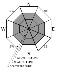
MODERATE avalanche danger still exists in near and above treeline terrain due to lingering wind slabs as well as some potential new wind slabs. While these wind slabs should have become more difficult to trigger, human-triggered avalanches remain possible. 

2. Moderate

?

Above Treeline
Heightened avalanche conditions on specific terrain features. Evaluate snow and terrain carefully; identify features of concern.

2. Moderate

?

Near Treeline
Heightened avalanche conditions on specific terrain features. Evaluate snow and terrain carefully; identify features of concern.

1. Low

?

Below Treeline
Generally safe avalanche conditions. Watch for unstable snow on isolated terrain features.
    Heightened avalanche conditions on specific terrain features. Evaluate snow and terrain carefully; identify features of concern.
Avalanche Problem 1: Wind Slab
  • Type ?
  • Aspect/Elevation ?
  • Likelihood ?
    Certain
    Very Likely
    Likely
    Possible
    Unlikely
  • Size ?
    Historic
    Very Large
    Large
    Small

Shifting winds over the last 48 hours means that wind slabs could exist on almost any aspect in exposed near and above treeline terrain. The largest wind slabs should still exist on wind-loaded N-NE-E aspects and cross-loaded NW and SE aspects but smaller ones may also exist on slopes loaded by last night's NE winds. Some of these wind slabs could involve enough snow to bury or injure a person in the most wind-loaded areas. Most of the wind slabs should be more difficult to trigger today. However, larger triggers like multiple people on a slope or the right trigger in the right spot could still cause them to release especially in complex or extreme terrain like couloirs, cliffy areas, or on unsupported slopes. 

Use clues like cornices above slopes, blowing snow, ripples, drifted snow, hollow sounding snow, or other wind created surface textures to help identify where wind slabs may exist and avoid those areas in favor of the more sheltered areas where the snow is also more likely to remain softer.   


recent observations

* Yesterday in complex near treeline terrain below Saucer Lake (Echo Summit / Mt. Ralston area) a snowboarder intentionally triggered an avalanche with a snowboard cut. It ran down the 38 to 40 degree chute, over cliffs, and through a terrain trap (rocky chute). No one was caught in the avalanche but it did involve enough snow to bury or injure a person.

* A natural wind slab avalanche was reported near the ridge of National Geographic Bowl (Granite Chief Wilderness). Stomping on wind-loaded test slopes in this area and on Andesite Peak (Donner Summit) in the afternoon, produced shooting cracks up to 10 ft. long. After few additional kicks on the Andesite test slope, the wind slab slid downhill about a foot. Other wind-loaded test slopes in the Andesite and Castle Peak area did not react to cornice drops, ski cuts, or show signs of instability in snowpit tests. Yesterday morning on Incline Lake Peak (Mt. Rose backcountry), only one of several ski cuts and cornice drops onto test slopes caused a smaller wind slab failure. Blowing snow and active wind-loading was reported along the Sierra Crest and in the Mt. Rose area all day.

* Observations from below treeline terrain on Incline Lake Peak, the Castle Peak, and Andesite Ridge area, and from the Granite Chief area did not reveal active signs of instability, but a loose snow layer (facets) similar to the one found in the Carson Pass and Ebbetts Pass areas that will need to be monitored did exist either below the recent snow or below a crust below the recent snow.

Weather and CURRENT CONDITIONS
weather summary

Yesterday's unsettled weather left another trace of new snow in most places with up to 2 inches reported in a few spots. The winds remained strong for much of the day and shifted to the N and NE during the night. The forecast calls for a milder, mostly sunny day today before the next storm arrives over the region tonight and tomorrow. The winds should shift back to the W and SW and start increasing today ahead of the storm. Snowfall could start late tonight with up to 2 inches expected overnight, but the bulk of the storm should arrive tomorrow during the day with the cold front. Another 5 to 9 inches of new snow accumulation is expected during the day tomorrow.   

CONDITIONS ALONG THE SIERRA CREST BETWEEN 8200 FT. AND 9200 FT. IN THE LAST 24 HOURS
6am temperature: 12 to 19 deg. F.
Max. temperature: 16 to 26 deg. F.
Average ridgetop wind direction: SW shifting to NE
Average ridgetop wind speed: Yesterday: 30 to 40 mph | Overnight: 25 mph
Maximum ridgetop wind gust: 90 mph
New snowfall: trace to 2 inches
Total snow depth: 32 to 57 inches
Two-Day Mountain Weather Forecast Produced in partnership with the Reno NWS
For 7000 ft. to 8000 ft.
Sunday Sunday Night Monday
Weather: Sunny becoming partly cloudy as the day progresses Partly cloudy becoming mostly cloudy with a chance of snow Cloudy with snow
Temperatures: 33 to 38 deg. F. 16 to 21 deg. F. 24 to 29 deg. F.
Mid Slope Winds: West Southwest Southwest
Wind Speed: Light in the morning increasing to 10 to 15 mph with gusts to 40 mph in the afternoon 20 to 30 mph with gusts to 55 mph increasing to 65 mph after midnight 15 to 25 mph with gusts to 60 mph decreasing to 35 mph in the afternoon
Expected snowfall: 0 up to 2 5 to 8
For 8000 ft. to 9000 ft.
Sunday Sunday Night Monday
Weather: Sunny becoming partly cloudy as the day progresses Partly cloudy becoming mostly cloudy with a chance of snow Cloudy with snow
Temperatures: 29 to 35 deg. F. 14 to 19 deg. F. 20 to 26 deg. F.
Ridge Top Winds: West Southwest Southwest
Wind Speed: 20 to 30 mph with gusts to 50 mph 30 to 50 mph with gusts to 80 mph increasing to 90 mph after midnight 30 to 40 mph with gusts to 90 mph decreasing to 15 to 25 mph with gusts to 45 mph in the afternoon
Expected snowfall: 0 up to 2 5 to 9
Disclaimer

This avalanche advisory is provided through a partnership between the Tahoe National Forest and the Sierra Avalanche Center. This advisory covers the Central Sierra Nevada Mountains between Yuba Pass on the north and Ebbetts Pass on the south. Click here for a map of the forecast area. This advisory applies only to backcountry areas outside established ski area boundaries. This advisory describes general avalanche conditions and local variations always occur. This advisory expires 24 hours after the posted time unless otherwise noted. The information in this advisory is provided by the USDA Forest Service who is solely responsible for its content.

For a recorded version of the Avalanche Advisory call (530) 587-3558 x258