THIS AVALANCHE FORECAST EXPIRED ON February 28, 2018 @ 6:58 am
Avalanche Forecast published on February 27, 2018 @ 6:58 am
Issued by Steve Reynaud - Tahoe National Forest

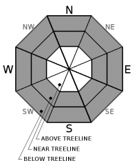
Moderate avalanche danger will exist throughout the forecast area at all elevations due to wind slab and storm slab avalanchesWind slabs will be possible in near and above treeline terrain and storm slabs in near and below treeline terrain.  Heightened avalanche conditions exist with human triggered avalanches possible today.


2. Moderate

?

Above Treeline
Heightened avalanche conditions on specific terrain features. Evaluate snow and terrain carefully; identify features of concern.

2. Moderate

?

Near Treeline
Heightened avalanche conditions on specific terrain features. Evaluate snow and terrain carefully; identify features of concern.

2. Moderate

?

Below Treeline
Heightened avalanche conditions on specific terrain features. Evaluate snow and terrain carefully; identify features of concern.
    Heightened avalanche conditions on specific terrain features. Evaluate snow and terrain carefully; identify features of concern.
Avalanche Problem 1: Wind Slab
  • Type ?
  • Aspect/Elevation ?
  • Likelihood ?
    Certain
    Very Likely
    Likely
    Possible
    Unlikely
  • Size ?
    Historic
    Very Large
    Large
    Small

Moderate to strong SW winds yesterday created sensitive winds slabs that caused both natural and human triggered avalanches.  Winds began to shift towards the NE yesterday afternoon and have been in the moderate to strong range overnight.  This will cause wind slabs to be on most aspects in near treeline and above treeline terrain.  Human triggered wind slab avalanches large enough to bury a backcountry user (size D2) will remain possible today.  

Look for recent avalanches, shooting cracks, cornices above slopes, blowing snow, or other wind created surface textures to identify where wind slabs may exist.  Avoid steep wind loaded terrain.

Avalanche Problem 2: Storm Slab
  • Type ?
  • Aspect/Elevation ?
  • Likelihood ?
    Certain
    Very Likely
    Likely
    Possible
    Unlikely
  • Size ?
    Historic
    Very Large
    Large
    Small

Storm slabs will be unlikely today but not impossible in wind protected near and below treeline terrain.  Weaknesses observed yesterday within the new storm snow could continue into today with cold overnight temperatures and limited settlement of the new storm snow.  Loose dry avalanches, sluffing, will continue to be an issue in steep wind protected areas with the low density unconsolidated snow.  On NW-N-NE aspects in below and near treeline terrain, a layer of previous near surface facets is now buried below the last couple storms.  Reactivity has been limited with snowpack tests and informal observations, but that could change as the overlying snow settles, gains strength, and becomes a slab.

Recent avalanche activity, cracking, collapsing, whumpfing, and/or snowpack tests can help determine where storm slabs may exist.  Avoiding steep slopes with signs of instability.   

recent observations

* Wind slab avalanches were reported yesterday on Andesite Ridge (Donner Summit area) and the East Ridge of Tamarack Peak (Mt. Rose area).  Signs of wind slab instability were reported on Carson Pass.

* Loose dry avalanches, sluffing, was reported throughout the forecast area with new low density storm snow.

* The buried layer of previous near surface facets has been observed in below and near treeline areas.  Snowpack tests and informal observations have been limited in reactivity due to the lack of a cohesive slab above the weak layer.


Weather and CURRENT CONDITIONS
weather summary

Most of the snow showers have ended in our forecast area overnight and have left us with clearing skies, continued below average temperatures, and strong NE winds above 8000'.  Snow totals were impressive with high intensity snowfall in a short period of time yesterday morning and through the daytime hours.  Most areas received 8 to 12'' of new snow but some areas doubled that with close to 2' of snow!

Today and Wednesday will be a break before our next winter storm arrives.  A major winter storm is forecasted for Thursday through Saturday with high winds and significant snow.  Snow levels should remain below 5000' with multiple feet of snow expected.  


CONDITIONS ALONG THE SIERRA CREST BETWEEN 8200 FT. AND 9200 FT. IN THE LAST 24 HOURS
6am temperature: 9 to 11 deg. F.
Max. temperature: 23 deg. F.
Average ridgetop wind direction: SW shifting to NE
Average ridgetop wind speed: 30 to 50 mph
Maximum ridgetop wind gust: 74 mph
New snowfall: 9 to 22 inches
Total snow depth: 40 to 69 inches
Two-Day Mountain Weather Forecast Produced in partnership with the Reno NWS
For 7000 ft. to 8000 ft.
Tuesday Tuesday Night Wednesday
Weather: Partly cloudy then becoming sunny. Chance of snow showers in the morning. Partly cloudy then becoming clear. Mostly cloudy. Slight chance of snow showers in the afternoon.
Temperatures: 24 to 29 deg. F. 9 to 14 deg. F. 29 to 34 deg. F.
Mid Slope Winds: NE SW
Wind Speed: 10 to 15mph with gusts to 30mph. Light winds Light winds becoming SW at 10 to 15mph with gusts to 35mph in the afternoon.
Expected snowfall: Up to 1 0 Up to 1
For 8000 ft. to 9000 ft.
Tuesday Tuesday Night Wednesday
Weather: Partly cloudy then becoming sunny. Chance of snow showers in the morning. Partly cloudy then becoming clear. Mostly cloudy. Slight chance of snow showers in the afternoon.
Temperatures: 20 to 26 deg. F. 9 to 14 deg. F. 25 to 31 deg. F.
Ridge Top Winds: NE NE SW
Wind Speed: 20 to 30mph. Gusts to 60mph decreasing to 45mph in the afternoon. 10 to 15mph. Gusts to 35mph after midnight. 15 to 25mph. Gusts to 30mph increasing to 50mph in the afternoon.
Expected snowfall: Up to 1 0 Up to 1
Disclaimer

This avalanche advisory is provided through a partnership between the Tahoe National Forest and the Sierra Avalanche Center. This advisory covers the Central Sierra Nevada Mountains between Yuba Pass on the north and Ebbetts Pass on the south. Click here for a map of the forecast area. This advisory applies only to backcountry areas outside established ski area boundaries. This advisory describes general avalanche conditions and local variations always occur. This advisory expires 24 hours after the posted time unless otherwise noted. The information in this advisory is provided by the USDA Forest Service who is solely responsible for its content.

For a recorded version of the Avalanche Advisory call (530) 587-3558 x258