THIS AVALANCHE FORECAST EXPIRED ON March 4, 2018 @ 12:50 pm
Avalanche Forecast published on March 4, 2018 @ 6:50 am
Issued by Brandon Schwartz - Tahoe National Forest

Avalanche danger is MODERATE for all elevations. Even though snowpack stability is improving, human triggered avalanches remain possible. Keep in mind that most recreational avalanche accidents happen during periods of MODERATE or CONSIDERABLE danger. Wind slab, deep slab, and loose wet avalanche problems may be encountered today. Areas of unstable snow will exist within greater surrounding areas of seemingly stable snow.

2. Moderate

?

Above Treeline
Heightened avalanche conditions on specific terrain features. Evaluate snow and terrain carefully; identify features of concern.

2. Moderate

?

Near Treeline
Heightened avalanche conditions on specific terrain features. Evaluate snow and terrain carefully; identify features of concern.

2. Moderate

?

Below Treeline
Heightened avalanche conditions on specific terrain features. Evaluate snow and terrain carefully; identify features of concern.
    Heightened avalanche conditions on specific terrain features. Evaluate snow and terrain carefully; identify features of concern.
Avalanche Problem 1: Wind Slab
  • Type ?
  • Aspect/Elevation ?
  • Likelihood ?
    Certain
    Very Likely
    Likely
    Possible
    Unlikely
  • Size ?
    Historic
    Very Large
    Large
    Small

A few more inches of new snow fell last night combined with moderate speed SW winds. This will have created new wind slabs near treeline and above treeline on NW-N-NE-E SE aspects. Expected avalanche size up to D2 is possible (large enough to bury or injure a person).

Identify and avoid areas of potentially unstable wind slab. Slopes below cornice features and wind pillows are suspect today. Snow surface cracking in wind exposed areas is an additional clue of unstable snow in the immediate area.

Avalanche Problem 2: Deep Slab
  • Type ?
  • Aspect/Elevation ?
  • Likelihood ?
    Certain
    Very Likely
    Likely
    Possible
    Unlikely
  • Size ?
    Historic
    Very Large
    Large
    Small

A deep slab avalanche problem is unlikely but not impossible near treeline and below treeline on NW-N-NE aspects. The faceted (loose, sugary) weak layer of concern is buried 4+ feet deep in the snowpack in most areas. Triggering failure of this weak layer has become unlikely, but snowpit tests indicate that if collapse of this layer can be triggered, a large destructive avalanche would occur. Expected avalanche size is D3 (could bury and destroy a car, damage a truck, destroy a wood frame house, or break a few trees).

This is a low likelihood, high consequence scenario. In steeper terrain, isolated trigger points such as single trees, exposed rocks, and convex slope rollovers should be avoided. In these locations the weak layer may be closer to the snow surface and easier to trigger. Large triggers such as multiple people on the same slope at once have a greater chance of triggering. The only way to completely avoid this problem is to stay on slopes 30 degrees or less in slope angle without steeper terrain above.

Avalanche Problem 3: Loose Wet
  • Type ?
  • Aspect/Elevation ?
  • Likelihood ?
    Certain
    Very Likely
    Likely
    Possible
    Unlikely
  • Size ?
    Historic
    Very Large
    Large
    Small

Warming this afternoon will be borderline for creating small areas of loose wet avalanche problems on lower elevation SE-S-SW aspects. This avalanche problem is expected to become more likely tomorrow. Avoid steep sun exposed slopes where roller balls are occurring.

recent observations

* 8:15 am addition: Just in and too late for inclusion in today's advisory: Skier triggered Deep Slab avalanche on Schallenberger Ridge (Donner Summit area). More info below. Click through all of the tabs in the observation for all photos and info.

* Numerous natural wind slab and storm slab avalanches occurred during this past storm cycle. In many areas evidence of these avalanches is nearly completely covered by new snow.

* A small skier triggered wind slab avalanche occurred yesterday on Andesite Peak on a NE aspect above treeline (Donner Summit area).

* Widespread shooting cracks and whumpfing were reported on a SW aspect 34 degree slope between 7,500' to 7,825' in the Wood Creek Drainage (Mount Rose area).

* A deeply buried facet layer is the weak layer of concern for the deep slab problem. Snowpit tests targeting this layer indicate that this layer is becoming increasingly difficult to trigger but is still conducive to propagation.

Weather and CURRENT CONDITIONS
weather summary

Snow showers last night into this morning will diminish as the day progresses. The most intense snow showers this morning are expected along the E side of Lake Tahoe with the possibility of a few quick inches of accumulation. Otherwise, decreasing cloud cover and decreasing SW to W ridgetop winds are forecast for today. Clearing skies and warming air temperatures are expected over the next few days.

CONDITIONS ALONG THE SIERRA CREST BETWEEN 8200 FT. AND 9200 FT. IN THE LAST 24 HOURS
6am temperature: 10 to 16 deg. F.
Max. temperature: 20 to 28 deg. F.
Average ridgetop wind direction: SW
Average ridgetop wind speed: 30 mph
Maximum ridgetop wind gust: 52 mph
New snowfall: 2 to 6 inches
Total snow depth: 65 to 96 inches
Two-Day Mountain Weather Forecast Produced in partnership with the Reno NWS
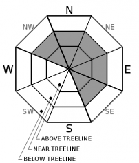
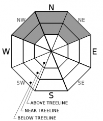
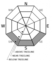
For 7000 ft. to 8000 ft.
Sunday Sunday Night Monday
Weather: Mostly cloudy skies becoming party cloudy. Isolated snow showers in the morning. Partly cloudy skies, becoming clear. Sunny skies.
Temperatures: 25 to 30 deg. F. 5 to 10 deg. F. 32 to 37 deg. F.
Mid Slope Winds: SW to W Variable Variable
Wind Speed: 10 to 15 mph with gusts to 25 mph in the morning, becoming light. Light winds Light winds
Expected snowfall: Up to 1 0 0
For 8000 ft. to 9000 ft.
Sunday Sunday Night Monday
Weather: Mostly cloudy skies becoming party cloudy. Isolated snow showers in the morning. Partly cloudy skies, becoming clear. Sunny skies.
Temperatures: 19 to 27 deg. F. 6 to 11 deg. F. 28 to 34 deg. F.
Ridge Top Winds: SW to W Variable SW
Wind Speed: 15 to 20 mph. Gusts to 45 mph decreasing to 35 mph in the afternoon. Light winds 10 to 15 mph with gusts to 25 mph in the morning, becoming light.
Expected snowfall: Up to 1 0 0
Disclaimer

This avalanche advisory is provided through a partnership between the Tahoe National Forest and the Sierra Avalanche Center. This advisory covers the Central Sierra Nevada Mountains between Yuba Pass on the north and Ebbetts Pass on the south. Click here for a map of the forecast area. This advisory applies only to backcountry areas outside established ski area boundaries. This advisory describes general avalanche conditions and local variations always occur. This advisory expires 24 hours after the posted time unless otherwise noted. The information in this advisory is provided by the USDA Forest Service who is solely responsible for its content.

For a recorded version of the Avalanche Advisory call (530) 587-3558 x258