


For 7000 ft. to 8000 ft.
| Tuesday | Tuesday Night | Wednesday | |
|---|---|---|---|
| Weather: | Partly cloudy then becoming mostly cloudy. | Mostly cloudy. | Mostly cloudy. |
| Temperatures: | 39 to 45 deg. F. | 19 to 24 deg. F. | 44 to 49 deg. F. |
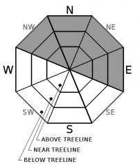
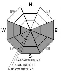
| Mid Slope Winds: | S | ||
| Wind Speed: | Light winds | Light winds | Light winds becoming S 10 to 15mph with gusts to 35mph in the afternoon. |
| Expected snowfall: | 0 | 0 | 0 |
For 8000 ft. to 9000 ft.
| Tuesday | Tuesday Night | Wednesday | |
|---|---|---|---|
| Weather: | Partly cloudy then becoming mostly cloudy. | Mostly cloudy. | Mostly cloudy. |
| Temperatures: | 36 to 42 deg. F. | 17 to 22 deg. F. | 39 to 45 deg. F. |
| Ridge Top Winds: | S | S | |
| Wind Speed: | Light winds | Light winds becoming S 10 to 15mph with gusts to 25mph after midnight. | 15 to 25mph. Gusts to 30mph increasing to 45mph in the afternoon. |
| Expected snowfall: | 0 | 0 | 0 |


