THIS AVALANCHE FORECAST EXPIRED ON December 10, 2013 @ 6:30 am
Avalanche Forecast published on December 9, 2013 @ 6:30 am
Issued by Andy Anderson - Tahoe National Forest - Sierra Avalanche Center

CONSIDERABLE avalanche danger exists in near and below treeline terrain on NW-N-NE aspects 30 degrees and steeper due to widespread persistent slabs. Human triggered persistent slabs remain likely today in near and below treeline terrain. Remotely triggered avalanches can occur under these conditions. MODERATE avalanche danger remains on the near and above treeline NW-N-NE-E-SE aspects due to lingering wind slabs. In addition to the avalanche danger a myriad of season-ending obstacles still lurks just below the surface. Conservative terrain selection, careful snowpack evaluation, and conservative decision-making are essential.

2. Moderate

?

Above Treeline
Heightened avalanche conditions on specific terrain features. Evaluate snow and terrain carefully; identify features of concern.

3. Considerable

?

Near Treeline
Dangerous avalanche conditions. Careful snowpack evaluation, cautious route-finding and conservative decision-making essential.

3. Considerable

?

Below Treeline
Dangerous avalanche conditions. Careful snowpack evaluation, cautious route-finding and conservative decision-making essential.
    Dangerous avalanche conditions. Careful snowpack evaluation, cautious route-finding and conservative decision-making essential.
Avalanche Problem 1: Persistent Slab
  • Type ?
  • Aspect/Elevation ?
  • Likelihood ?
    Certain
    Very Likely
    Likely
    Possible
    Unlikely
  • Size ?
    Historic
    Very Large
    Large
    Small

Human triggered avalanches remain likely in near and below treeline terrain on NW-N-NE aspects where the recent snow rests on top of the Dec. 7th facet layer. Any areas that had snow cover prior to this storm remain suspect. The recent snow currently represents a soft slab, because it has slowly started to consolidate. At the same time the cold clear weather has started to weaken the new snow. Depending on how fast it consolidates or how fast it weakens the new snow may become more (faster consolidation) or less (faster weakening) slab-like. A more slab-like layer would make these persistent slabs easier to trigger.

Since fractures can travel so easily through the persistent weak layer, people can trigger persistent slabs remotely while standing in low angle terrain or on ridgelines or anywhere that the snowpack under their feet connects to steeper and/or deeper terrain. Wide propagation and avalanche activity on lower angle slopes to around 30 degrees remains likely today below treeline.

Avalanche Problem 2: Wind Slab
  • Type ?
  • Aspect/Elevation ?
  • Likelihood ?
    Certain
    Very Likely
    Likely
    Possible
    Unlikely
  • Size ?
    Historic
    Very Large
    Large
    Small

Some of the wind slabs that formed during the storm may still linger on the near and above treeline NW-N-NE-E-SE aspects. In many areas the strong E and NE winds that occurred last night and this morning have scoured snow away from these winds slabs making them smaller and more shallow. In areas where a mix of rocks, dirt, and a few inches of old snow existed below these slabs they have become more difficult to trigger. However, some of these wind slabs could sit on top of the persistent weak layers mentioned above on the near treeline NW-N-NE aspects. Human triggered avalanche activity resulting from the failure of these wind slabs remains likely on slopes where the persistent weak layers exist and possible on slopes that just hold wind slabs.

recent observations

More widespread collapsing, whumphing, and cracking occurred yesterday in the Tamarack Peak area (photo, video, snowpit) and in the Silver Peak area (more info). These failures failures occurred as Dec. 7th facet layer below the recent snow collapsed in response to the additional weight of a person. These collapses propagated along the Dec. 7th facets for long distances across entire slopes. People could initiate the collapses in areas where less snow existed or in low angle terrain, and the fracture could travel into deeper and steeper terrain. In some areas enough anchors (stumps, bushes, logs, trees, rocks, etc.) existed to prevent the collapses from traveling too far. Near Silver Peak a party reported seeing a small snowboarder triggered slide on a north facing slope (more info).

In the Tamarack Peak area smaller, skier-triggered shooting cracks also occurred on wind loaded NE facing test slopes in near treeline terrain (photo). The wind slabs on these slopes remained small and did not extend very far down slope.

Barely covered rocks, stumps, logs, and other hard immobile objects still exist on all slopes especially on those facing the southern half of the compass. The shallow snowpack does not have enough structure or strength to keep a person above all these things. It only camouflages their existence.

Weather and CURRENT CONDITIONS
weather summary

Clear, dry weather has returned due to a high pressure ridge over the region. As this ridge established itself the E and NE winds increased. Since about 6 pm last night wind speeds have averaged 30-45 mph with gusts to 74 mph along the ridge tops. These easterly winds should begin decreasing today. By tomorrow the forecast calls for light and variable winds across the area. Temperatures should begin to warm some in the mountains over the next few days; however, the inversion keeping the valleys cold should remain in place. Expect daytime highs in the low to mid 20's above 7000 ft today and upper 20's to low 30's tomorrow. 

CONDITIONS ALONG THE SIERRA CREST BETWEEN 8200 FT. AND 9200 FT. IN THE LAST 24 HOURS
6am temperature: 5 to 11 deg. F.
Max. temperature: 12 to 16 deg. F.
Average ridgetop wind direction: E to NE
Average ridgetop wind speed: Before 6pm yesterday: 5-15 mph | After 6pm: 30-45 mph
Maximum ridgetop wind gust: 74 mph
New snowfall: 0 inches
Total snow depth: 19-31 inches
Two-Day Mountain Weather Forecast Produced in partnership with the Reno NWS
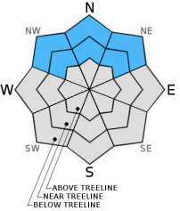
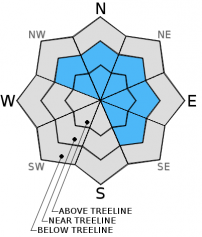
For 7000 ft. to 8000 ft.
Monday Monday Night Tuesday
Weather: Sunny Clear Sunny
Temperatures: 23-28 deg. F. 18-25 deg. F. 28-34 deg. F.
Mid Slope Winds: East Variable Variable
Wind Speed: 10-20 mph with gusts to 30 mph decreasing to 10-15 mph in the afternoon Light Light
Expected snowfall: 0 0 0
For 8000 ft. to 9000 ft.
Monday Monday Night Tuesday
Weather: Sunny Clear Sunny
Temperatures: 20-27 deg. F. 18-25 deg. F. 28-34 deg. F.
Ridge Top Winds: East East North
Wind Speed: 25-35 mph with gusts to 60 mph decreasing to 10-20 mph with gusts of 30-40 mph in the afternoon 10-15 mph decreasing after midnight Light in the morning becoming 10-15 mph in the afternoon
Expected snowfall: 0 0 0
Disclaimer

This avalanche advisory is provided through a partnership between the Tahoe National Forest and the Sierra Avalanche Center. This advisory covers the Central Sierra Nevada Mountains between Yuba Pass on the north and Ebbetts Pass on the south. Click here for a map of the forecast area. This advisory applies only to backcountry areas outside established ski area boundaries. This advisory describes general avalanche conditions and local variations always occur. This advisory expires 24 hours after the posted time unless otherwise noted. The information in this advisory is provided by the USDA Forest Service who is solely responsible for its content.