In partnership with: 
| Date and time of observation or avalanche occurrence | Location | Media | Observation made by |
|---|---|---|---|
|
03/10/2018 - 15:00 Snowpack Observation |
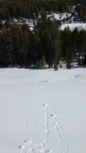
Silverado Cabin Creek, Deep Creek, or Pole Creek Area |
Public | |
|
03/10/2018 - 15:00 Snowpack Observation |
Upper Shirley Canyon Cabin Creek, Deep Creek, or Pole Creek Area |
 |
Public |
|
03/10/2018 - 15:15 Snowpack Observation |
Snowshed Wall Donner Summit Area |
  |
Educator Tahoe Mountain Scho |
|
03/11/2018 - 01:00 Snowpack Observation |
Elephants Hump Carson Pass Area |
   |
Forecaster |
|
03/11/2018 - 08:00 Snowpack Observation |
Wildflower Ridge Donner Summit Area |
  |
Public |
|
03/11/2018 - 11:30 Snowpack Observation |
Chickadee Ridge Mount Rose Area |
Public | |
|
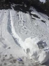
03/11/2018 - 12:30 Avalanche Observation |
Nat Geo, Granite Chief Peak Cabin Creek, Deep Creek, or Pole Creek Area |
   |
Guide Alpenglow Expeditio |
|
03/11/2018 - 14:00 Snowpack Observation |
Powderhouse Luther Pass Area (including Job and Freel) |
|
Professional Observer |
|
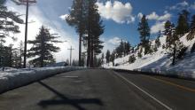
03/12/2018 - 08:15 Snowpack Observation |
Highway 431 - Mt Rose Highway Mount Rose Area |
   |
Public |
|
03/12/2018 - 12:30 Snowpack Observation |
Jakes Peak West Shore Area |
     |
Forecaster |
|
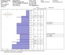
03/13/2018 - 11:00 Avalanche Observation |
Andesite Peak Donner Summit Area |
  |
Forecaster |
|
03/13/2018 - 12:00 Snowpack Observation |
Incline Lake Peak/Slab Cliffs Mount Rose Area |
  |
Forecaster |
|
03/14/2018 - 12:00 Avalanche Observation |
Castle Peak/Andesite Peak Donner Summit Area |
   |
Forecaster |
|
03/14/2018 - 13:00 Avalanche Observation |
Tamarack Peak Mount Rose Area |
Public | |
|
03/14/2018 - 13:45 Snowpack Observation |
Powderhouse Peak Luther Pass Area (including Job and Freel) |
|
Forecaster |


This website is owned and maintained by the non-profit arm of the Sierra Avalanche Center. Some of the content is updated by the USDA avalanche forecasters including the forecasts and some observational data. The USDA is not responsible for any advertising, fund-raising events/information, or sponsorship information, or other content not related to the forecasts and the data pertaining to the forecasts.