In partnership with: 
| Date and time of observation or avalanche occurrence | Location | Media | Observation made by |
|---|---|---|---|
|
12/17/2016 - 12:00 Snowpack Observation |
Tamarack Peak Mount Rose Area |
  |
Forecaster |
|
12/17/2016 - 08:50 Snowpack Observation |
Elephant's Back Carson Pass Area |
   |
Public |
|
12/16/2016 - 13:00 Snowpack Observation |
Tamarack Peak Mount Rose Area |
|
Forecaster |
|
12/16/2016 - 12:30 Snowpack Observation |
Andesite Peak Donner Summit Area |
     |
Forecaster |
|
12/16/2016 - 12:30 Avalanche Observation |
East Face of Judah Donner Summit Area |
 |
Guide Alpenglow Expeditio |
|
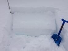
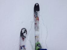
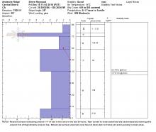
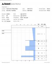
12/16/2016 - 12:20 Snowpack Observation |
South side of Relay Ridge Mount Rose Area |
 |
Public |
|
12/16/2016 - 11:30 Snowpack Observation |
Southwest of Red Lake Peak Carson Pass Area |
Public | |
|
12/16/2016 - 10:30 Snowpack Observation |
Frog Lake Carson Pass Area |
   |
Professional Observer |
|
12/16/2016 - 07:00 Avalanche Observation |
Bronco Chutes Mount Rose Area |
  |
Forecaster |
|
12/16/2016 - 00:30 Avalanche Observation |
Tamarack Peak Mount Rose Area |
   |
Forecaster |
|
12/15/2016 - 12:30 Snowpack Observation |
Relay Peak Mount Rose Area |
 |
Forecaster |
|
12/14/2016 - 12:40 Snowpack Observation |
Tamarack Peak Mount Rose Area |
    |
Public |
|
12/14/2016 - 11:30 Snowpack Observation |
Andesite Peak Donner Summit Area |
  |
Forecaster |
|
12/13/2016 - 12:00 Snowpack Observation |
Tamarack Peak Mount Rose Area |
   |
Forecaster |
|
12/13/2016 - 10:00 Snowpack Observation |
Elephants Back Carson Pass Area |
 |
Professional Observer |


This website is owned and maintained by the non-profit arm of the Sierra Avalanche Center. Some of the content is updated by the USDA avalanche forecasters including the forecasts and some observational data. The USDA is not responsible for any advertising, fund-raising events/information, or sponsorship information, or other content not related to the forecasts and the data pertaining to the forecasts.