In partnership with: 
| Date and time of observation or avalanche occurrence | Location | Media | Observation made by |
|---|---|---|---|
|
12/24/2016 - 12:00 Snowpack Observation |
Blue Lakes Carson Pass Area |
  |
Professional Observer |
|
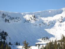
12/24/2016 - 11:30 Avalanche Observation |
Andesite Peak Donner Summit Area |
   |
Forecaster |
|
12/24/2016 - 11:15 Avalanche Observation |
Lowest open pitch lookers right of traditional skin track Blackwood Canyon or Ward Canyon Area |
  |
Public |
|
12/24/2016 - 11:10 Avalanche Observation |
Silver Peak Cabin Creek, Deep Creek, or Pole Creek Area |
      |
Forecaster |
|
12/24/2016 - 11:00 Avalanche Observation |
S side Ward Canyon Blackwood Canyon or Ward Canyon Area |
 |
Guide Donner Summit Avalanche Semina |
|
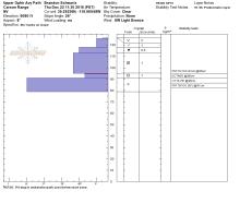
12/23/2016 - 13:30 Snowpack Observation |
Tamarack Peak Mount Rose Area |
   ,
,
|
Forecaster |
|
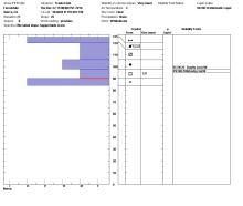
12/22/2016 - 12:00 Snowpack Observation |
North Side of Castle Peak Donner Summit Area |
 |
Forecaster |
|
12/22/2016 - 12:00 Snowpack Observation |
Ophir Peak Mount Rose Area |
 |
Forecaster |
|
12/22/2016 - 00:00 Snowpack Observation |
Forestdale Carson Pass Area |
  |
Professional Observer |
|
12/21/2016 - 12:20 Snowpack Observation |
Castle Peak Donner Summit Area |
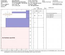
|
Forecaster |
|
12/21/2016 - 11:34 Snowpack Observation |
Incline Peak Mount Rose Area |
  |
Public |
|
12/20/2016 - 12:00 Snowpack Observation |
Meiss Carson Pass Area |
  |
Professional Observer |
|
12/20/2016 - 10:15 Snowpack Observation |
Tamarack Peak Mount Rose Area |
 |
Forecaster |
|
12/19/2016 - 13:00 Snowpack Observation |
South aspect just over ridge from Hourglass Bowl Mount Rose Area |
 |
Public |
|
12/19/2016 - 13:00 Snowpack Observation |
1 km W of Castle Peak Donner Summit Area |
 |
Educator Donner Summit Avalanche Semina |


This website is owned and maintained by the non-profit arm of the Sierra Avalanche Center. Some of the content is updated by the USDA avalanche forecasters including the forecasts and some observational data. The USDA is not responsible for any advertising, fund-raising events/information, or sponsorship information, or other content not related to the forecasts and the data pertaining to the forecasts.