In partnership with: 
| Date and time of observation or avalanche occurrence | Location | Media | Observation made by |
|---|---|---|---|
|
01/06/2017 - 14:30 Snowpack Observation |
Carson Pass Carson Pass Area |
   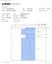 |
Public |
|
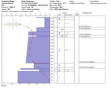
01/06/2017 - 14:15 Snowpack Observation |
Andesite Peak Donner Summit Area |
|
Forecaster |
|
01/06/2017 - 12:30 Snowpack Observation |
Deep Creek Ridge Cabin Creek, Deep Creek, or Pole Creek Area |
|
Forecaster |
|
01/06/2017 - 09:10 Snowpack Observation |
Herlan Peak Mount Rose Area |
Public | |
|
01/05/2017 - 16:15 Snowpack Observation |
South ridge Mt. Houghton Mount Rose Area |
  |
Public |
|
01/05/2017 - 15:21 Avalanche Observation |
Main fork and S. fork of Davis Creek Mount Rose Area |
    |
Public |
|
01/05/2017 - 12:00 Snowpack Observation |
Jakes Peak West Shore Area |
  |
Forecaster |
|
01/05/2017 - 11:00 Avalanche Observation |
Fireplug Mount Rose Area |
   |
Forecaster |
|
01/05/2017 - 11:00 Snowpack Observation |
Silver Peak Cabin Creek, Deep Creek, or Pole Creek Area |
  |
Guide Alpenglow Expeditio |
|
01/05/2017 - 10:53 Avalanche Observation |
Fireplug Mount Rose Area |
Public | |
|
01/04/2017 - 22:00 Avalanche Observation |
Castle Peak - north side Donner Summit Area |
 |
Public |
|
01/04/2017 - 18:00 Avalanche Observation |
Secret Peak West Shore Area |
  |
Forecaster |
|
01/04/2017 - 17:00 Avalanche Observation |
Jakes Peak West Shore Area |
 |
Forecaster |
|
01/04/2017 - 16:00 Avalanche Observation |
Jakes Peak West Shore Area |
    |
Forecaster |
|
01/04/2017 - 15:00 Avalanche Observation |
Andesite Ridge Donner Summit Area |
 |
Forecaster |


This website is owned and maintained by the non-profit arm of the Sierra Avalanche Center. Some of the content is updated by the USDA avalanche forecasters including the forecasts and some observational data. The USDA is not responsible for any advertising, fund-raising events/information, or sponsorship information, or other content not related to the forecasts and the data pertaining to the forecasts.