In partnership with: 
| Date and time of observation or avalanche occurrence | Location | Media | Observation made by |
|---|---|---|---|
|
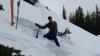
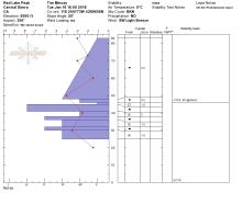
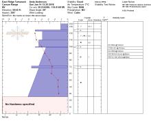
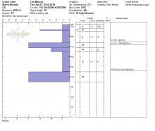
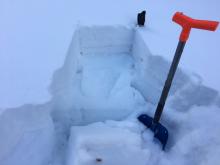
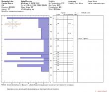
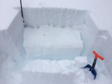
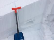
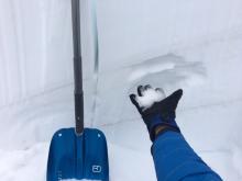
01/18/2018 - 11:00 Snowpack Observation |
Fireplug Mount Rose Area |
Forecaster | |
|
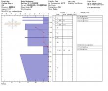
01/17/2018 - 15:00 Snowpack Observation |
Powderhouse Luther Pass Area (including Job and Freel) |
  |
Public |
|
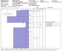
01/17/2018 - 11:00 Snowpack Observation |
Slab Cliffs Mount Rose Area |
 |
Forecaster |
|
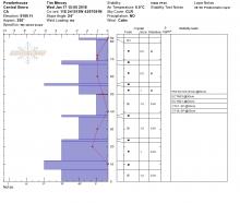
01/16/2018 - 14:00 Snowpack Observation |
Red Lake Peak Carson Pass Area |
 |
Public |
|
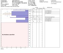
01/16/2018 - 12:30 Snowpack Observation |
Elephants Hump Carson Pass Area |
|
Forecaster |
|
01/15/2018 - 14:30 Snowpack Observation |
Castle Peak Donner Summit Area |
 |
Forecaster |
|
01/14/2018 - 13:30 Snowpack Observation |
East Ridge Tamarack Peak Mount Rose Area |
 |
Forecaster |
|
01/13/2018 - 12:00 Snowpack Observation |
Elephants Back Carson Pass Area |
 |
Forecaster |
|
01/12/2018 - 12:45 Snowpack Observation |
Castle Peak Donner Summit Area |
     |
Forecaster |
|
01/12/2018 - 11:20 Snowpack Observation |
Slab Cliffs Mount Rose Area |
   |
Forecaster |
|
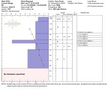
01/11/2018 - 13:30 Snowpack Observation |
Red Lake Peak Carson Pass Area |
 |
Public |
|
01/11/2018 - 11:45 Snowpack Observation |
Rubicon Peak and Peak 9,269' West Shore Area |
   |
Forecaster |
|
01/10/2018 - 15:30 Snowpack Observation |
Mosquito Lake Bear Valley Area |
|
Public |
|
01/10/2018 - 12:00 Snowpack Observation |
East Ridge Tamarack Peak Mount Rose Area |
    |
Forecaster |
|
01/09/2018 - 12:30 Snowpack Observation |
Incline Peak Near Summit Mount Rose Area |
 |
Public |


This website is owned and maintained by the non-profit arm of the Sierra Avalanche Center. Some of the content is updated by the USDA avalanche forecasters including the forecasts and some observational data. The USDA is not responsible for any advertising, fund-raising events/information, or sponsorship information, or other content not related to the forecasts and the data pertaining to the forecasts.