In partnership with: 
| Date and time of observation or avalanche occurrence | Location | Media | Observation made by |
|---|---|---|---|
|
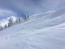
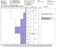
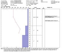
02/25/2017 - 13:04 Snowpack Observation |
Andesite Peak Donner Summit Area |
Guide Tahoe Mountain Scho |
|
|
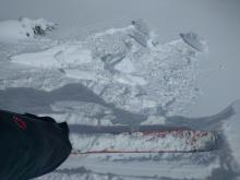
02/25/2017 - 12:30 Avalanche Observation |
National Geographic Bowl, Granite Chief Cabin Creek, Deep Creek, or Pole Creek Area |
 |
Guide Alpenglow Expeditio |
|
02/25/2017 - 12:00 Snowpack Observation |
The Nipple Carson Pass Area |
   |
Professional Observer |
|
02/25/2017 - 12:00 Snowpack Observation |
Jakes Peak West Shore Area |
  |
Forecaster |
|
02/25/2017 - 10:30 Snowpack Observation |
Donner Ridge Donner Summit Area |
  |
Educator Donner Summit Avalanche Semina |
|
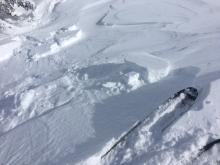
02/25/2017 - 10:10 Avalanche Observation |
Fireplug Mount Rose Area |
      |
Public |
|
02/24/2017 - 13:30 Snowpack Observation |
Negro Canyon Donner Summit Area |
  |
Forecaster |
|
02/24/2017 - 13:30 Snowpack Observation |
Blackwood Ridge Blackwood Canyon or Ward Canyon Area |
Public | |
|
02/24/2017 - 12:00 Snowpack Observation |
Ophir Peak Mount Rose Area |
   |
Forecaster |
|
02/24/2017 - 10:45 Snowpack Observation |
Andesite Peak Donner Summit Area |
 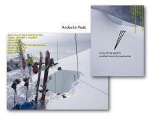 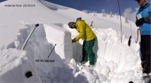 |
Educator Donner Summit Avalanche Semina |
|
02/23/2017 - 14:30 Snowpack Observation |
E end Boreal Ridge south of I-80 rest area Donner Summit Area |
 |
Guide Donner Summit Avalanche Semina |
|
02/23/2017 - 13:00 Snowpack Observation |
Cinder Cone Sawtooth Ridge to Tahoe City |
  |
Forecaster |
|
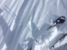
02/23/2017 - 13:00 Avalanche Observation |
SE chute abover lower angora lake Echo Summit Area |
 |
Public |
|
02/23/2017 - 13:00 Avalanche Observation |
Lower bench below Echo Peak Echo Summit Area |
Public | |
|
02/23/2017 - 12:00 Snowpack Observation |
Freel and Job's Luther Pass Area (including Job and Freel) |
  |
Professional Observer |


This website is owned and maintained by the non-profit arm of the Sierra Avalanche Center. Some of the content is updated by the USDA avalanche forecasters including the forecasts and some observational data. The USDA is not responsible for any advertising, fund-raising events/information, or sponsorship information, or other content not related to the forecasts and the data pertaining to the forecasts.

