In partnership with: 
| Date and time of observation or avalanche occurrence | Location | Media | Observation made by |
|---|---|---|---|
|
02/12/2017 - 12:30 Avalanche Observation |
Due south of Rose Knob Peak Mount Rose Area |
  |
Public |
|
02/12/2017 - 12:00 Snowpack Observation |
Blue Lakes Carson Pass Area |
    |
Professional Observer |
|
02/12/2017 - 11:45 Snowpack Observation |
Tram Ridge / Shirley canyon Cabin Creek, Deep Creek, or Pole Creek Area |
 |
Guide Alpenglow Expeditio |
|
02/12/2017 - 11:30 Avalanche Observation |
Main bowl of Rose Knob Peak East Shore Area |
Public | |
|
02/11/2017 - 15:15 Snowpack Observation |
West of Relay Ridge Mount Rose Area |
   |
Public |
|
02/11/2017 - 15:00 Snowpack Observation |
Gold Peak Cabin Creek, Deep Creek, or Pole Creek Area |
Guide Alpenglow Expeditio |
|
|
02/11/2017 - 14:30 Snowpack Observation |
Schallenberger Ridge Donner Summit Area |
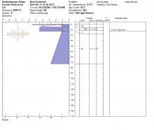 |
Guide Tahoe Mountain Scho |
|
02/11/2017 - 13:30 Snowpack Observation |
Andesite Peak Donner Summit Area |
   |
Guide Tahoe Mountain Scho |
|
02/11/2017 - 13:00 Snowpack Observation |
Powderhouse Ridge Luther Pass Area (including Job and Freel) |
    |
Professional Observer |
|
02/11/2017 - 13:00 Snowpack Observation |
Incline Lake Peak Mount Rose Area |
  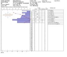
|
Forecaster |
|
02/11/2017 - 12:20 Avalanche Observation |
Incline Peak Mount Rose Area |
 |
Public |
|
02/11/2017 - 12:00 Snowpack Observation |
Tram Ridge / Shirley canyon Cabin Creek, Deep Creek, or Pole Creek Area |
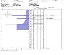 |
Guide Alpenglow Expeditio |
|
02/11/2017 - 12:00 Snowpack Observation |
Blue Lakes Rd Carson Pass Area |
      |
Professional Observer |
|
02/11/2017 - 11:00 Avalanche Observation |
Davis Creek Main Stem Mount Rose Area |
        |
Public |
|
02/11/2017 - 10:00 Avalanche Observation |
Incline Lake Peak Mount Rose Area |
Public |


This website is owned and maintained by the non-profit arm of the Sierra Avalanche Center. Some of the content is updated by the USDA avalanche forecasters including the forecasts and some observational data. The USDA is not responsible for any advertising, fund-raising events/information, or sponsorship information, or other content not related to the forecasts and the data pertaining to the forecasts.