In partnership with: 
| Date and time of observation or avalanche occurrence | Location | Media | Observation made by |
|---|---|---|---|
|
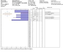
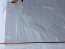
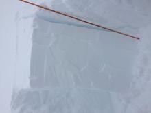
02/05/2017 - 12:00 Snowpack Observation |
Andesite Peak Donner Summit Area |
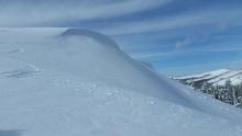 |
Guide Tahoe Mountain Scho |
|
02/05/2017 - 09:00 Avalanche Observation |
Jakes Peak Desolation Wilderness Area (including Emerald Bay) |
  |
Public |
|
02/05/2017 - 08:00 Avalanche Observation |
Upper Spencer's Lake Outside of the Forecast Area |
  |
Public |
|
02/04/2017 - 14:30 Snowpack Observation |
Silver Peak Cabin Creek, Deep Creek, or Pole Creek Area |
     |
Forecaster |
|
02/04/2017 - 14:00 Snowpack Observation |
North aspect, south of Peter Grub Hut Donner Summit Area |
   |
Public |
|
02/04/2017 - 14:00 Snowpack Observation |
Andesite Peak Donner Summit Area |
 |
Guide Tahoe Mountain Scho |
|
02/03/2017 - 13:00 Snowpack Observation |
Donner Peak Donner Summit Area |
  |
Forecaster |
|
02/03/2017 - 12:00 Snowpack Observation |
Powderhouse Luther Pass Area (including Job and Freel) |
 |
Public |
|
02/03/2017 - 11:00 Snowpack Observation |
East Ridge Tamarack Peak Mount Rose Area |
    |
Forecaster |
|
02/02/2017 - 11:00 Avalanche Observation |
Andesite Peak Donner Summit Area |
    |
Forecaster |
|
02/01/2017 - 12:00 Snowpack Observation |
Blackwood Ridge Blackwood Canyon or Ward Canyon Area |
  |
Forecaster |
|
01/31/2017 - 14:00 Snowpack Observation |
Horsetail Falls Echo Summit Area |
 |
Public |
|
01/31/2017 - 12:30 Snowpack Observation |
Waterhouse Peak Luther Pass Area (including Job and Freel) |
   |
Forecaster |
|
01/30/2017 - 12:00 Snowpack Observation |
Rubicon Peak West Shore Area |
 |
Forecaster |
|
01/30/2017 - 12:00 Snowpack Observation |
Jobs Sister Luther Pass Area (including Job and Freel) |
     |
Professional Observer |


This website is owned and maintained by the non-profit arm of the Sierra Avalanche Center. Some of the content is updated by the USDA avalanche forecasters including the forecasts and some observational data. The USDA is not responsible for any advertising, fund-raising events/information, or sponsorship information, or other content not related to the forecasts and the data pertaining to the forecasts.

