In partnership with: 
Use this page to view archived advisories. The table below shows the overall danger rating and the bottom line for the 20 most recent advisories. Click on the time and date link above each danger rating icon to view the full advisory for that day. Use the date chooser or the pager at the bottom to scroll through the older advisories.
|
Date the forecast was published: |
Bottom Line | |
|---|---|---|
|
Click here to see the full forecast for 2009-12-16 |
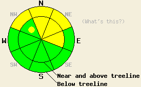
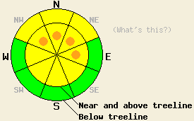
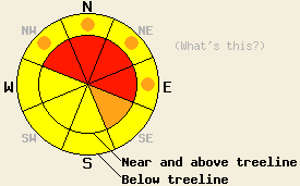
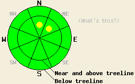
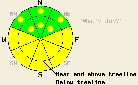
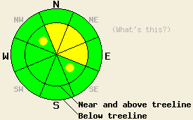
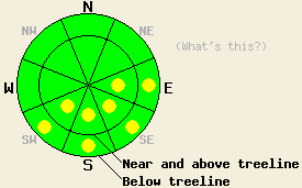
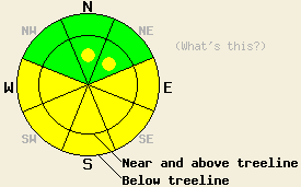
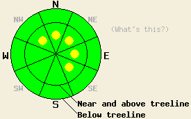
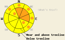
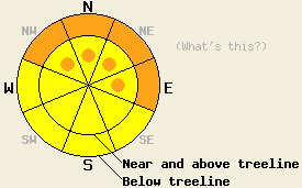
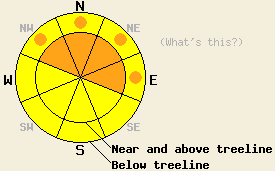
December 16, 2009 at 8:01 Near and below treeline MODERATE avalanche danger exists on sheltered NW-N-NE aspects steeper than 32 degrees, today. Human triggering of large, destructive avalanches with serious consequences will be possible in these areas. Above treeline on slopes steeper than 35 degrees, MODERATE avalanche danger exists on wind-loaded N-NE-E aspects with pockets of MODERATE danger on cross-loaded NW aspects. |
 |
|
Click here to see the full forecast for 2009-12-15 |
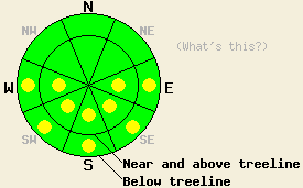
December 15, 2009 at 7:57 Near and below treeline MODERATE avalanche danger exists on NW-N-NE aspects steeper than 32 degrees, today. Human triggering of large, destructive avalanches with serious consequences will be possible in these areas. Above treeline pockets of MODERATE avalanche danger exist on wind-loaded NW-N-NE-E aspects steeper than 35 degrees. |
 |
|
Click here to see the full forecast for 2009-12-14 |
December 14, 2009 at 8:00 Near and below treeline MODERATE avalanche danger exists on NW-N-NE aspects steeper than 32 degrees, today. Human triggering of large, destructive avalanches with serious consequences will be possible in these areas. Near and above treeline MODERATE avalanche danger exists on wind-loaded N-NE-E aspects steeper than 35 degrees. |
 |
|
Click here to see the full forecast for 2009-12-13 |
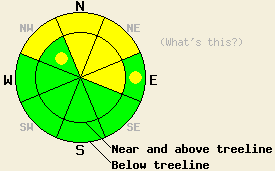
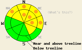
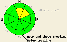
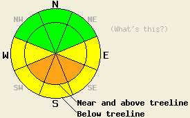
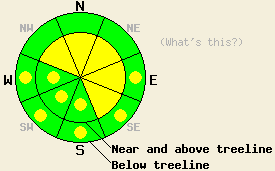
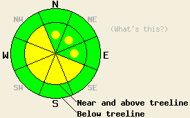
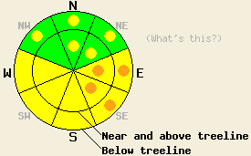
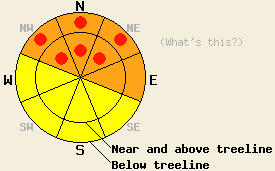
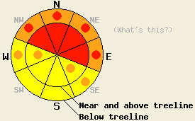
December 13, 2009 at 8:00 Avalanche danger is CONSIDERABLE today in wind loaded areas near and above treeline on NW-N-NE-E-SE aspects, 34 degrees and steeper. Near treeline and below treeline, avalanche danger is CONSIDERABLE on NW-N-NE aspects near and above 7,000' on slopes 32 degrees and steeper due to possible overloading of persistent weak layers near the base of the snowpack. In other areas, avalanche danger is MODERATE. |
 |
|
Click here to see the full forecast for 2009-12-12 |
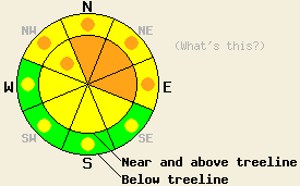
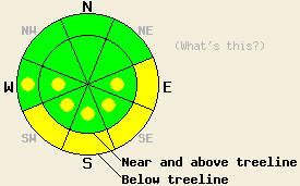
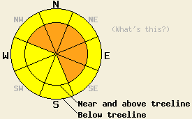
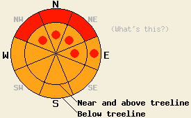
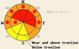
December 12, 2009 at 8:01 Avalanche danger is HIGH today in wind loaded areas near and above treeline on NW-N-NE-E aspects, 34 degrees and steeper. Near treeline and below treeline, avalanche danger is expected to rise to HIGH danger on NW-N-NE aspects near and above 7,000' on slopes 32 degrees and steeper, due to overloading of persistent weak layers near the base of the snowpack. In other areas, avalanche danger will range from MODERATE to CONSIDERABLE today. |
 |
|
Click here to see the full forecast for 2009-12-11 |
December 11, 2009 at 8:00 Near and above treeline, pockets of CONSIDERABLE danger are expected to form today in wind loaded areas on NW-N-NE-E aspects, 34 degrees and steeper. Below treeline avalanche danger is MODERATE on NW-N-NE aspects, 34 degrees and steeper due to continued instability of a variety of weak layers. |
 |
|
Click here to see the full forecast for 2009-12-10 |
December 10, 2009 at 8:01 MODERATE avalanche danger exists on NW-N-NE-E aspects steeper than 35 degrees at all elevations. |
 |
|
Click here to see the full forecast for 2009-12-09 |
December 9, 2009 at 7:58 Pockets of CONSIDERABLE avalanche danger exist on NW-N-NE-E aspects steeper than 35 degrees at all elevations. MODERATE danger exists on cross-loaded NW and SE aspects steeper than 35 degrees near and above treeline. |
 |
|
Click here to see the full forecast for 2009-12-08 |
December 8, 2009 at 8:00 Near and above treeline CONSIDERABLE avalanche danger exists on N-NE-E aspects 32 degrees and steeper. Pockets of CONSIDERABLE danger exist on NW aspects. Below treeline pockets of CONSIDERABLE danger exist on NW-N-NE-E aspects 32 degrees and steeper. |
 |
|
Click here to see the full forecast for 2009-12-07 |
December 7, 2009 at 8:00 Near and above treeline, avalanche danger is HIGH on NW-N-NE-E aspects 34 degrees and steeper. Below treeline, avalanche danger is MODERATE with pockets of CONSIDERABLE danger in open areas on NW-N-NE-E aspects and in creek beds 34 degrees and steeper. |
 |
|
Click here to see the full forecast for 2009-12-06 |
December 6, 2009 at 7:54 For most areas, avalanche danger is LOW. Isolated pockets of MODERATE avalanche danger exist above 8,000' both near treeline and below treeline on NW-N-NE aspects, 32 degrees and steeper. |
 |
|
Click here to see the full forecast for 2009-12-05 |
December 5, 2009 at 7:53 For most areas, avalanche danger is LOW. Isolated pockets of MODERATE avalanche danger exist above 8,000' both near treeline and below treeline on NW-N-NE aspects, 32 degrees and steeper. |
 |
|
Click here to see the full forecast for 2009-12-04 |
December 4, 2009 at 7:41 LOW avalanche danger exists in most areas. However, pockets of MODERATE avalanche danger remain on NW-N-NE aspects above 8,000' in near-treeline and below-treeline areas on slopes 32 degrees and steeper. |
 |
|
Click here to see the full forecast for 2009-12-03 |
December 3, 2009 at 7:28 LOW avalanche danger exists in most areas. However, pockets of MODERATE avalanche danger remain on NW-N-NE aspects above 8,000' in near-treeline and below-treeline areas on slopes 32 degrees and steeper. |
 |
|
Click here to see the full forecast for 2009-12-02 |
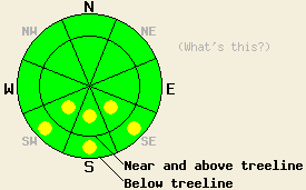
December 2, 2009 at 7:41 Pockets of MODERATE avalanche danger exist above 8,000' in near treeline and below treeline areas on slopes 32 degrees and steeper. For all other areas, avalanche danger is LOW. |
 |
|
Click here to see the full forecast for 2009-12-01 |
December 1, 2009 at 7:48 Pockets of MODERATE avalanche danger linger above 8,700' in near treeline and below treeline areas on slopes 32 degrees and steeper. For all other areas, avalanche danger is LOW. |
 |
|
Click here to see the full forecast for 2009-11-30 |
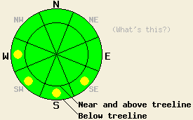
November 30, 2009 at 7:26 LOW avalanche danger exists across most of the forecast area. Pockets of MODERATE danger still remain on NW-N-NE aspects steeper than 32 degrees above 8700'. |
 |
|
Click here to see the full forecast for 2009-11-29 |
November 29, 2009 at 8:00 LOW avalanche danger exists across most of the forecast area. Some isolated pockets of MODERATE danger may still remain on NW-N-NE aspects steeper than 32 degrees above 8700'. |
 |
|
Click here to see the full forecast for 2009-11-28 |
November 28, 2009 at 8:00 Areas of MODERATE avalanche danger exist above 8,700ft. on NW-N-NE aspects 32 degrees and steeper both above and below treeline. For all other areas, avalanche danger is LOW. |
 |
|
Click here to see the full forecast for 2009-11-27 |
November 27, 2009 at 8:02 Areas of MODERATE avalanche danger exist above 8,700' on NW-N-NE aspects 32 degrees and steeper both above and below treeline. For all other areas, avalanche danger is LOW. Expect the avalanche danger to increase quickly this afternoon and overnight during the storm. |
 |
|
Click here to see the full forecast for 2009-11-25 |
November 25, 2009 at 7:46 Areas of MODERATE avalanche danger exist above 8,700' on NW-N-NE aspects 32 degrees and steeper both above and below treeline. For all other areas, avalanche danger is LOW. |
 |
|
Click here to see the full forecast for 2009-11-24 |
November 24, 2009 at 7:44 Areas of MODERATE avalanche danger exist above 8,700' on NW-N-NE aspects 32 degrees and steeper both above and below treeline. For all other areas, avalanche danger is LOW. |
 |
|
Click here to see the full forecast for 2009-11-23 |
November 23, 2009 at 7:41 Areas of MODERATE danger remain above 8,700' on N and NE aspects, steeper than 32 degrees where a layer of faceted snow crystals sits above the October basal ice layer and below the recent storm snow. Human triggered avalanches remain possible in areas where this specific snowpack structure exists. |
 |
|
Click here to see the full forecast for 2009-11-22 |
November 22, 2009 at 8:20 Complex conditions exist during the early season. On N-NE aspects above 8800 ft and steeper than 32 degrees where the combination of facets on top of an ice layer with new snow above exists the avalanche danger is MODERATE . Human-triggered avalanches will be possible on these slopes today. |
 |
|
Click here to see the full forecast for 2009-11-21 |
November 21, 2009 at 7:59 On slopes steeper than 30 degrees, the avalanche danger is MODERATE on N-NE aspects above 8700 ft. Human-triggered avalanches will be possible on these slopes today. |
 |
|
Click here to see the full forecast for 2009-11-20 |
November 20, 2009 at 9:03 Fall Conditions Update Despite very little snow on the ground, conditions are complex and the snowpack structure is weak. Pay attention out there! |
|
|
Click here to see the full forecast for 2009-10-17 |
October 17, 2009 at 9:38 Fall Avalanche Statement |
|
|
Click here to see the full forecast for 2009-10-13 |
October 13, 2009 at 7:08 Fall Avalanche Statement |
|
|
Click here to see the full forecast for 2009-10-12 |
October 12, 2009 at 20:53 Fall avalanche statement |
|
|
Click here to see the full forecast for 2009-06-23 |
June 23, 2009 at 6:53 The Tahoe National Forest Sierra Avalanche Center is closed for the season. Avalanche advisories will resume in the fall of 2009. Check back once the snow begins to fly. |
|
|
Click here to see the full forecast for 2009-04-26 |
April 26, 2009 at 6:57 We have stopped issuing daily avalanche advisories until the fall of 2009. The avalanche danger can and will change quickly during this spring. Continue to monitor changing conditions and use caution when traveling in the backcountry. For general spring avalanche information read the full spring avalanche statement. |
|
|
Click here to see the full forecast for 2009-04-25 |
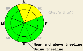
April 25, 2009 at 7:00 Today, the avalanche danger should remain LOW for all aspects and elevations. Some sluffing may occur in the new snow today. Some very small, isolated, human-triggerable winds slabs may exist on wind-loaded aspects near and above treeline. |
 |
|
Click here to see the full forecast for 2009-04-24 |
April 24, 2009 at 7:00 Today, the avalanche danger should remain LOW for all aspects and elevations. Some minor sluffing may occur in the new snow today. Some very small, isolated, human-triggerable winds slabs may form on N-NE-E aspects near and above treeline by this afternoon. |
 |
|
Click here to see the full forecast for 2009-04-23 |
April 23, 2009 at 7:00 This morning, the avalanche danger is LOW for all elevations and aspects. Above treeline on E-SE-S-SW-W aspects and below treeline on W aspects pockets of MODERATE avalanche danger should quickly develop on slopes 37 degrees and steeper in response to daytime warming. Larger areas of MODERATE avalanche danger should develop on slopes 37 degrees and steeper on E-SE-S-SW aspects below treeline. |
 |
|
Click here to see the full forecast for 2009-04-22 |
April 22, 2009 at 6:16 Early this morning, avalanche danger is LOW for all elevations and aspects. Avalanche danger will rise to MODERATE on E-SE-S-SW-W aspects 37 degrees and steeper in response to daytime warming. Pockets of MODERATE danger will also form on NW-N-NE aspects, 37 degrees and steeper as warming occurs. |
 |
|
Click here to see the full forecast for 2009-04-21 |
April 21, 2009 at 6:46 Early this morning, avalanche danger is LOW for all elevations and aspects. Avalanche danger will rise to MODERATE on E-SE-S-SW-W aspects 37 degrees and steeper in response to daytime warming. Pockets of MODERATE danger will also form on NW-N-NE aspects, 37 degrees and steeper as warming occurs. |
 |
|
Click here to see the full forecast for 2009-04-20 |
April 20, 2009 at 6:57 Early this morning, avalanche danger is LOW for all elevations and aspects. Avalanche danger will quickly rise to MODERATE on E-SE-S-SW-W aspects 37 degrees and steeper in response to daytime warming. Pockets of MODERATE danger will also form on NW-N-NE aspects, 37 degrees and steeper as warming occurs. |
 |
|
Click here to see the full forecast for 2009-04-19 |
April 19, 2009 at 6:46 This morning the avalanche danger is LOW. Areas of MODERATE avalanche danger should quickly develop due to daytime warming on E-SE-S-SW-W aspects 37 degrees and steeper at all elevations today. |
 |
|
Click here to see the full forecast for 2009-04-18 |
April 18, 2009 at 6:53 This morning the avalanche danger is LOW. Areas of MODERATE avalanche danger should quickly develop due to daytime warming on E-SE-S-SW-W aspects 37 degrees and steeper at all elevations today. |
 |
|
Click here to see the full forecast for 2009-04-17 |
April 17, 2009 at 7:00 This morning the avalanche danger is LOW. Areas of MODERATE avalanche danger should quickly develop due to daytime warming on E-SE-S-SW-W aspects 37 degrees and steeper at all elevations today. |
 |
|
Click here to see the full forecast for 2009-04-16 |
April 16, 2009 at 6:50 For the mountains directly south of Lake Tahoe, areas of CONSIDERABLE avalanche danger will develop near and above treeline on SE-S-SW aspects, 37 degrees and steeper in response to daytime warming. For all other locations, expect areas of MODERATE danger to develop at all elevations on E-SE-S-SW-W aspects, 37 degrees and steeper in response to daytime warming. |
 |
|
Click here to see the full forecast for 2009-04-15 |
April 15, 2009 at 6:50 For most areas, avalanche danger is LOW for all elevations and aspects. Normal caution is advised. Pockets of MODERATE danger exist in the mountains directly south of Lake Tahoe near and above treeline on SE-S-SW aspects, 37 degrees and steeper. |
 |
|
Click here to see the full forecast for 2009-04-14 |
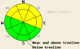
April 14, 2009 at 6:50 Avalanche danger is LOW for all elevations and aspects. Normal caution is advised. |
 |
|
Click here to see the full forecast for 2009-04-13 |
April 13, 2009 at 7:00 This morning the avalanche danger is LOW. Pockets of MODERATE avalanche danger should quickly develop due to daytime warming on E-SE-S-SW-W aspects 37 degrees and steeper at all elevations today. |
 |
|
Click here to see the full forecast for 2009-04-12 |
April 12, 2009 at 7:00 This morning the avalanche danger is LOW. Areas of MODERATE avalanche danger should quickly develop due to daytime warming on E-SE-S-SW-W aspects 37 degrees and steeper at all elevations today. |
 |
|
Click here to see the full forecast for 2009-04-11 |
April 11, 2009 at 7:00 This morning the avalanche danger is LOW. Areas of MODERATE avalanche danger should quickly develop due to daytime warming on E-SE-S-SW-W aspects 37 degrees and steeper at all elevations today.
|
 |
|
Click here to see the full forecast for 2009-04-10 |
April 10, 2009 at 6:54 Near and above treeline, areas of MODERATE avalanche danger exist on NW-N-NE-E-SE aspects 37 degrees and steeper. Below treeline, avalanche danger is LOW. The areas of greatest avalanche danger will be found south of Hwy 50. |
 |
|
Click here to see the full forecast for 2009-04-09 |
April 9, 2009 at 6:56 Near and above treeline, areas of MODERATE avalanche danger exist on NW-N-NE-E-SE aspects 37 degrees and steeper. Below treeline, avalanche danger is LOW. |
 |
|
Click here to see the full forecast for 2009-04-08 |
April 8, 2009 at 6:57 Near and above treeline, avalanche danger is MODERATE on NW-N-NE-E-SE aspects, 37 degrees and steeper. Below treeline, avalanche danger is LOW with pockets of MODERATE danger developing in open sun exposed areas on E-SE-S-SW-W aspects, 37 degrees and steeper in response to daytime warming. |
 |
|
Click here to see the full forecast for 2009-04-07 |
April 7, 2009 at 7:00 This morning, avalanche danger is LOW for all elevations and aspects. Pockets of MODERATE danger could form this afternoon below treeline on all aspects, 35 degrees and steeper in response to a combination of daytime warming and light rain. |
 |
|
Click here to see the full forecast for 2009-04-06 |
April 6, 2009 at 6:58 This morning, avalanche danger is LOW for all elevations and aspects. Pockets of MODERATE danger will form at all elevations on E-SE-S-SW-W aspects, 35 degrees and steeper in response to daytime warming. |
 |
|
Click here to see the full forecast for 2009-04-05 |
April 5, 2009 at 6:40 This morning, avalanche danger is LOW for all elevations and aspects. Pockets of MODERATE danger will form at all elevations on E-SE-S-SW-W aspects, 35 degrees and steeper in response to daytime warming. |
 |
|
Click here to see the full forecast for 2009-04-04 |
April 4, 2009 at 6:50 This morning, avalanche danger is LOW for all elevations and aspects. Pockets of MODERATE danger will form at all elevations on E-SE-S-SW-W aspects, 37 degrees and steeper in response to daytime warming. |
 |
|
Click here to see the full forecast for 2009-04-03 |
April 3, 2009 at 6:54 For the vast majority of locations, avalanche danger is LOW. Some small and isolated pockets of instability are possible in the most heavily wind loaded areas near and above treeline on slopes 37 degrees and steeper. These areas of instability are not expected to present a significant hazard to backcountry travelers. |
 |
|
Click here to see the full forecast for 2009-04-02 |
April 2, 2009 at 6:52 This morning, avalanche danger is LOW for all elevations and aspects. Pockets of MODERATE danger will form at all elevations on SE-S-SW aspects, 37 degrees and steeper in response to daytime warming. |
 |
|
Click here to see the full forecast for 2009-04-01 |
April 1, 2009 at 6:59 This morning, avalanche danger is LOW for all elevations and aspects. Pockets of MODERATE danger may develop below treeline on sun-exposed, SE-S-SW-W aspects, 37 degrees and steeper in response to daytime warming. |
 |
|
Click here to see the full forecast for 2009-03-31 |
March 31, 2009 at 7:00 This morning, avalanche danger is LOW for all elevations and aspects. Pockets of MODERATE danger should develop at all elevations on sun-exposed, E-SE-S-SW aspects, 37 degrees and steeper in response to daytime warming. |
 |
|
Click here to see the full forecast for 2009-03-30 |
March 30, 2009 at 7:00 This morning, avalanche danger is LOW for all elevations and aspects. Pockets of MODERATE danger may develop below treeline on sun-exposed, SE-S-SW aspects, 37 degrees and steeper in response to daytime warming. |
 |
|
Click here to see the full forecast for 2009-03-29 |
March 29, 2009 at 6:44 This morning, avalanche danger is LOW for all elevations and aspects. Pockets of MODERATE danger may develop on E-SE-S-SW aspects, 37 degrees and steeper in response to daytime warming. |
 |
|
Click here to see the full forecast for 2009-03-28 |
March 28, 2009 at 6:52 Early this morning, avalanche danger is LOW for all elevations and aspects. Avalanche danger will quickly rise to MODERATE at all elevations on E-SE-S-SW-W aspects, 37 degrees and steeper in response to daytime warming. |
 |
|
Click here to see the full forecast for 2009-03-27 |
March 27, 2009 at 6:49 This morning, avalanche danger is LOW for all elevations and aspects. Pockets of MODERATE danger will develop at all elevations on E-SE-S-SW-W aspects in response to daytime warming. |
 |
|
Click here to see the full forecast for 2009-03-26 |
March 26, 2009 at 7:01 Today, the avalanche danger is LOW for all elevations and aspects. Small, wet-snow instabilities may develop due to daytime warming on the sun-exposed E-SE-S-SW-W aspects 37 degrees and steeper below treeline today. |
 |
|
Click here to see the full forecast for 2009-03-25 |
March 25, 2009 at 6:56 This morning, the avalanche danger is LOW for all elevations and aspects. Pockets of MODERATE avalanche danger may develop due to daytime warming on the E-SE-S-SW-W aspects 35 degrees and steeper at all elevations today. |
 |
|
Click here to see the full forecast for 2009-03-24 |
March 24, 2009 at 7:00 Near and above treeline, MODERATE avalanche danger exists on SE-S-SW-W-NW aspects 35 degrees and steeper. Below treeline, avalanche danger is LOW. |
 |
|
Click here to see the full forecast for 2009-03-23 |
March 23, 2009 at 6:51 Near and above treeline, areas of MODERATE avalanche danger exist on all aspects, 35 degrees and steeper. Below treeline, avalanche danger is LOW. |
 |
|
Click here to see the full forecast for 2009-03-22 |
March 22, 2009 at 6:56 Near and above treeline, avalanche danger is CONSIDERABLE on NW-N-NE-E-SE aspects, 35 degrees and steeper. Below treeline, avalanche danger is MODERATE in open areas, 35 degrees and steeper. |
 |
|
Click here to see the full forecast for 2009-03-21 |
March 21, 2009 at 7:00 For today, avalanche danger is LOW for all elevations and aspects. Normal caution is advised. Avalanche danger is expected to increase significantly overnight with 1 to 3 feet of new snow and natural avalanche activity possible. |
 |
|
Click here to see the full forecast for 2009-03-20 |
March 20, 2009 at 6:57 This morning the avalanche danger is LOW for all aspects and elevations. On E-SE-S-SW-W aspects, the avalanche danger will quickly rise to MODERATE on slopes steeper than 35 degrees for all elevations due to daytime warming. |
 |
|
Click here to see the full forecast for 2009-03-19 |
March 19, 2009 at 7:00 The avalanche danger is LOW on NW-N-NE aspects. On E-SE-S-SW-W aspects, the avalanche danger will increase to MODERATE on slopes steeper than 35 degrees for all elevations due to daytime warming. |
 |
|
Click here to see the full forecast for 2009-03-18 |
March 18, 2009 at 7:00 Near and above treeline, pockets of MODERATE avalanche danger exist on N-NE aspects, 37 degrees and steeper. On E-SE-S-SW-W aspects, the avalanche danger will increase to MODERATE on slopes steeper than 35 degrees for all elevations due to daytime warming. |
 |
|
Click here to see the full forecast for 2009-03-17 |
March 17, 2009 at 6:55 Near and above treeline, pockets of MODERATE avalanche danger exist on N-NE aspects, 37 degrees and steeper. At all elevations on E-SE-S-SW-W aspects, avalanche danger will become MODERATE with pockets of CONSIDERABLE danger forming on E-SE aspects 37 degrees and steeper in response to daytime warming. |
 |
|
Click here to see the full forecast for 2009-03-16 |
March 16, 2009 at 6:52 Along the Sierra Crest north of Hwy 50, avalanche danger is MODERATE near and above treeline on N-NE-E aspects, 35 degrees and steeper. Pockets of MODERATE danger exist on similar terrain on NW and SE aspects. For all other areas, avalanche danger remains LOW. |
 |
|
Click here to see the full forecast for 2009-03-15 |
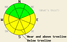
March 15, 2009 at 6:46 Avalanche danger is LOW for all elevations and aspects. Normal caution is advised. |
 |
|
Click here to see the full forecast for 2009-03-14 |
March 14, 2009 at 7:00 Avalanche danger is LOW for all elevations and aspects. LOW danger does not mean no danger. Continue to use safe travel habits and evaluate slopes carefully before weighting them. |
 |
|
Click here to see the full forecast for 2009-03-13 |
March 13, 2009 at 6:43 Avalanche danger is LOW for all elevations and aspects. LOW danger does not mean no danger. Continue to use safe travel habits and evaluated slopes carefully before weighting them. |
 |
|
Click here to see the full forecast for 2009-03-12 |
March 12, 2009 at 6:59 Avalanche danger is LOW for all elevations and aspects. Even though avalanche activity will remain unlikely today, very isolated human-triggered, hard-slab avalanches are not impossible above treeline. Normal caution is advised. |
 |
|
Click here to see the full forecast for 2009-03-11 |
March 11, 2009 at 6:46 Avalanche danger is LOW for all elevations and aspects. A very isolated human triggered hard slab avalanche is unlikely but not impossible today above treeline. Normal caution is advised. |
 |
|
Click here to see the full forecast for 2009-03-10 |
March 10, 2009 at 6:46 Near and above treeline avalanche danger is LOW with isolated pockets of MODERATE danger on N-NE-E aspects, 37 degrees and steeper. Below treeline, avalanche danger is LOW. |
 |
|
Click here to see the full forecast for 2009-03-09 |
March 9, 2009 at 6:59 Near and above treeline, avalanche danger is MODERATE on N-NE-E aspects, 35 degrees and steeper. Pockets of MODERATE danger exist on NW and SE aspects, 35 degrees and steeper. Below treeline, avalanche danger is LOW. |
 |
|
Click here to see the full forecast for 2009-03-08 |
March 8, 2009 at 6:42 Near and above treeline on open, wind-loaded slopes 37 degrees and steeper, isolated pockets of MODERATE avalanche danger could develop on NW-N-NE-E-SE aspects. Below treeline, avalanche danger is LOW. |
 |
|
Click here to see the full forecast for 2009-03-07 |
March 7, 2009 at 7:51 Near and above treeline on open, wind-loaded slopes 35 degrees and steeper, pockets of MODERATE avalanche danger exist on SE-S-SW-W-NW aspects. Below treeline, avalanche danger is LOW. |
 |
|
Click here to see the full forecast for 2009-03-06 |
March 6, 2009 at 8:00 Near and above treeline on open, wind-loaded slopes 35 degrees and steeper, pockets of MODERATE avalanche danger still exist on NW-N-NE-E-SE aspects. Below treeline, avalanche danger is LOW. |
 |
|
Click here to see the full forecast for 2009-03-05 |
March 5, 2009 at 7:53 Near and above treeline, avalanche danger is MODERATE on NW-N-NE-E-SE aspects, 35 degrees and steeper. Below treeline, avalanche danger is LOW. |
 |
|
Click here to see the full forecast for 2009-03-04 |
March 4, 2009 at 8:07 Near and above treeline, avalanche danger is HIGH on NW-N-NE-E-SE aspects, 35 degrees and steeper. Below treeline, avalanche danger is MODERATE with pockets of CONSIDERABLE danger in open, wind affected areas, 37 degrees and steeper. |
 |
|
Click here to see the full forecast for 2009-03-03 |
March 3, 2009 at 8:01 Near and above treeline, avalanche danger is HIGH on NW-N-NE-E-SE aspects, 35 degrees and steeper. Below treeline, avalanche danger is MODERATE with pockets of CONSIDERABLE danger in open, wind affected areas, 37 degrees and steeper. |
 |
|
Click here to see the full forecast for 2009-03-02 |
March 2, 2009 at 8:00 On slopes steeper than 35 degrees near and above treeline the avalanche danger is CONSIDERABLE for N-NE-E aspects with pockets of CONSIDERABLE on the NW and SE aspects. Below treeline the avalanche danger is MODERATE with pockets of CONSIDERABLE on open NW-N-NE-E-SE aspects 35 degrees and steeper. |
 |
|
Click here to see the full forecast for 2009-03-01 |
March 1, 2009 at 8:00 The avalanche danger will rise to CONSIDERABLE on slopes steeper than 35 degrees for all aspects and elevations that receive rain today. Above the rain line the avalanche danger is MODERATE with pockets of CONSIDERABLE developing on the on NW-N-NE aspects, 35 degrees and steeper by this afternoon. |
 |
|
Click here to see the full forecast for 2009-02-28 |
February 28, 2009 at 8:03 The avalanche danger is LOW for most elevations and aspects. Pockets of MODERATE danger still exist on NW-N-NE aspects, 35 degrees and steeper between 7,400' and 8,700'. Avalanches may be more difficult to trigger today; however, if triggered, they could be large and have serious consequences. |
 |
|
Click here to see the full forecast for 2009-02-27 |
February 27, 2009 at 7:49 Near and above treeline, avalanche danger is LOW with pockets of MODERATE danger on NW-N-NE-E-SE aspects, 35 degrees and steeper. Below treeline, avalanche danger is LOW with pockets of MODERATE danger on N-NE aspects, 37 degrees and steeper between 7,400' and 8,700'. Avalanches may be more difficult to trigger today, but are likely to be large in size with potential consequences severe. |
 |
|
Click here to see the full forecast for 2009-02-26 |
February 26, 2009 at 7:58 Near and above treeline, avalanche danger is MODERATE on N-NE aspects, 35 degrees and steeper. Pockets of MODERATE danger also exist on adjacent aspects, 35 degrees and steeper. Below treeline, avalanche danger is MODERATE on N-NE aspects, 35 degrees and steeper between 7,400' and 8,700'. |
 |
|
Click here to see the full forecast for 2009-02-25 |
February 25, 2009 at 7:58 Near and above treeline, avalanche danger is MODERATE on N-NE aspects, 35 degrees and steeper. Pockets of MODERATE danger also exist on adjacent aspects, 35 degrees and steeper. Below treeline, avalanche danger is MODERATE on N-NE aspects, 35 degrees and steeper between 7,400' and 8,700'. |
 |
|
Click here to see the full forecast for 2009-02-24 |
February 24, 2009 at 8:00 Near and above treeline on slopes steeper than 35 degrees, the avalanche danger is MODERATE with pockets CONSIDERABLE on NW-N-NE-E aspects. Below treeline the avalanche danger on slopes steeper than 35 degrees remains CONSIDERABLE on NW-N-NE-E aspects, especially on slopes below 7800' in elevation. On the SE-S-SW-W aspects the avalanche danger is MODERATE at all elevations on slopes steeper than 35 degrees. |
 |
|
Click here to see the full forecast for 2009-02-23 |
February 23, 2009 at 8:00 On slopes steeper than 35 degrees, the avalanche danger is CONSIDERABLE on NW-N-NE-E aspects at all elevations. Pockets of HIGH danger exist on the NW-N-NE aspects below 8700'. On the SE-S-SW-W aspects the avalanche danger is MODERATE at all elevations. The avalanche danger will be higher on any slopes that receive rain today. |
 |
|
Click here to see the full forecast for 2009-02-22 |
February 22, 2009 at 8:00 On slopes steeper than 35 degrees, the avalanche danger is HIGH on NW-N-NE aspects with pockets of HIGH danger on E aspects below 8700'. On the SE-S-SW-W aspects that receive rain today the avalanche danger is CONSIDERABLE. Above 8700' the avalanche danger is CONSIDERABLE on N-NE-E aspects on slopes steeper than 35 degrees and MODERATE on other aspects. |
 |
|
Click here to see the full forecast for 2009-02-21 |
February 21, 2009 at 7:59 Avalanche danger is MODERATE both above and below treeline on N-NE aspects 35 degrees and steeper due to persistent deep slab instability. Elsewhere, avalanche danger is LOW. Possible consequences from human triggered avalanches remain high. Use good travel habits to minimize risk. |
 |
|
Click here to see the full forecast for 2009-02-20 |
February 20, 2009 at 7:59 Avalanche danger is LOW for all elevations and aspects. Human triggered avalanches are unlikely but not impossible today. An unlikely human triggered avalanche may be large with severe consequences possible. Use normal caution and good travel habits while in the backcountry. |
 |
|
Click here to see the full forecast for 2009-02-19 |
February 19, 2009 at 8:01 Avalanche danger is LOW for all elevations and aspects. Human triggered avalanches are unlikely but not impossible today. An unlikely human triggered avalanche may be large with severe consequences possible. Use normal caution and good travel habits while in the backcountry. |
 |
|
Click here to see the full forecast for 2009-02-18 |
February 18, 2009 at 8:00 Near and above treeline the avalanche danger is CONSIDERABLE on NW-N-NE-E aspects steeper than 37 degrees. Pockets of CONSIDERABLE danger should also exist on slopes steeper than 37 degrees on the NW-N-NE-E aspects below treeline. Avalanche activity will be less likely on the windward SE-S-SW aspects. |
 |
|
Click here to see the full forecast for 2009-02-17 |
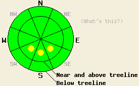
February 17, 2009 at 8:00 Large natural and human-triggered avalanches are likely. Near and above treeline the avalanche danger is HIGH on NW-N-NE-E aspects steeper than 35 degrees. Pockets of HIGH danger should also exist on slopes steeper than 35 degrees on the NW-N-NE-E aspects below treeline. Avalanche activity will be less likely on the windward SE-S-SW aspects. Backcountry travel in or around avalanche terrain is not recommended. |
 |
|
Click here to see the full forecast for 2009-02-16 |
February 16, 2009 at 8:00 Large natural and human-triggered avalanches are likely. Near and above treeline the avalanche danger will increase to HIGH on NW-N-NE-E aspects steeper than 35 degrees by this afternoon. Pockets of HIGH danger should also develop on slopes steeper than 35 degrees on cross loaded W aspects at all evelations and on the NW-N-NE-E aspects below treeline. Avalanche activity will be less likely on the windward SE-S-SW aspects. Backcountry travel in or around avalanche terrain is not recommended. |
 |


This website is owned and maintained by the non-profit arm of the Sierra Avalanche Center. Some of the content is updated by the USDA avalanche forecasters including the forecasts and some observational data. The USDA is not responsible for any advertising, fund-raising events/information, or sponsorship information, or other content not related to the forecasts and the data pertaining to the forecasts.


