In partnership with: 
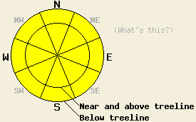
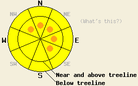
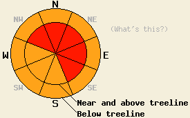
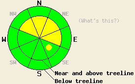
Use this page to view archived advisories. The table below shows the overall danger rating and the bottom line for the 20 most recent advisories. Click on the time and date link above each danger rating icon to view the full advisory for that day. Use the date chooser or the pager at the bottom to scroll through the older advisories.
|
Date the forecast was published: |
Bottom Line | |
|---|---|---|
|
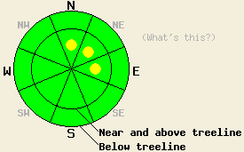
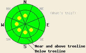
Click here to see the full forecast for 2011-11-28 |
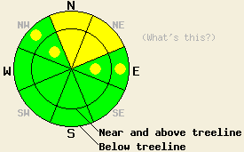
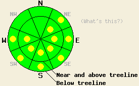
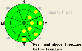
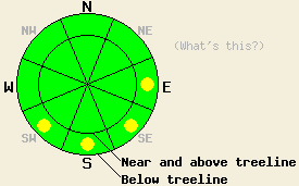
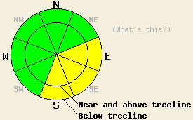
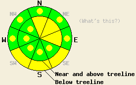
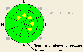
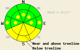
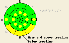
November 28, 2011 at 7:57 Above 8,000', areas of MODERATE avalanche danger exist both above and below treeline on N-NE aspects on slopes 32 degrees and steeper. Avalanche danger is LOW with pockets of MODERATE danger above 8,000' in both above and below treeline terrain on NW and E aspects on slopes 32 degrees and steeper. For all other areas, avalanche danger is LOW. |
 |
|
Click here to see the full forecast for 2011-11-27 |
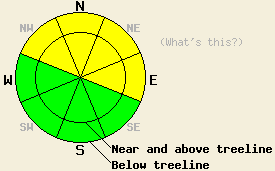
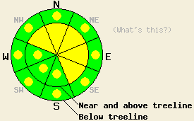
November 27, 2011 at 8:02 For areas above 8,000 ft. both above and below treeline, MODERATE avalanche danger exists on slopes 32 degrees and steeper on N-NE aspects. Pockets of MODERATE danger remain in the these areas on the NW and E aspects as well. The avalanche danger is LOW in all other areas. |
 |
|
Click here to see the full forecast for 2011-11-26 |
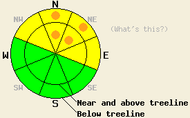
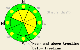
November 26, 2011 at 7:43 For areas above 8,000 ft. both above and below treeline, MODERATE avalanche danger exists on slopes 32 degrees and steeper on N-NE aspects. Pockets of MODERATE danger remain in the these areas on the NW and E aspects as well. The avalanche danger is LOW in all other areas. |
 |
|
Click here to see the full forecast for 2011-11-25 |
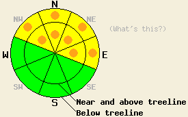
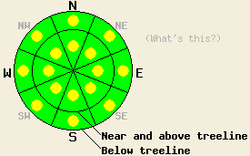
November 25, 2011 at 7:50 For areas above 8,000 ft. both above and below treeline, MODERATE avalanche danger exists on slopes 32 degrees and steeper on N-NE aspects. Pockets of MODERATE danger remain in the these areas on the NW and E aspects as well. The avalanche danger is LOW in all other areas. |
 |
|
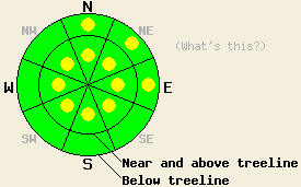
Click here to see the full forecast for 2011-11-24 |
November 24, 2011 at 8:01 For areas above 8,000 ft both above and below treeline, MODERATE avalanche danger exists on slopes 32 degrees and steeper on NW-N-NE-E aspects. The avalanche danger remains LOW in all other areas,. |
 |
|
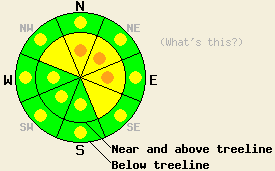
Click here to see the full forecast for 2011-11-23 |
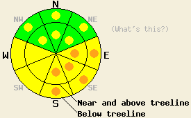
November 23, 2011 at 7:35 For areas above 8,000 ft, avalanche danger is MODERATE both above and below treeline on NW-N-NE-E aspects on slopes 32 degrees and steeper. Along the Sierra Crest in the northern half of the forecast area, pockets of CONSIDERABLE danger exist above 8,000 ft on N-NE aspects both above and below treeline on slopes 32 degrees and steeper. For all other areas, avalanche danger is LOW. |
 |
|
Click here to see the full forecast for 2011-11-22 |
November 22, 2011 at 7:54 On NW-N-NE-E aspects, avalanche danger is MODERATE both above and below treeline for areas above 8,000 ft on slopes 32 degrees and steeper. Along the Sierra Crest in the northern half of the forecast area, pockets of CONSIDERABLE danger exist on N-NE aspects both above and below treeline in areas above 8,000 ft on slopes 32 degrees and steeper. For all other areas, avalanche danger is LOW. |
 |
|
Click here to see the full forecast for 2011-11-21 |
November 21, 2011 at 7:54 On NW-N-NE-E aspects, the avalanche danger remains MODERATE both above and below treeline in areas above 8,000 ft on slopes 32 degrees and steeper. Some pockets of CONSIDERABLE danger where human-triggered avalanches remain likely still exist on N-NE aspects in these areas. In other areas, the avalanche danger is LOW. |
 |
|
Click here to see the full forecast for 2011-11-20 |
November 20, 2011 at 8:00 On NW-N-NE-E aspects, avalanche danger is MODERATE with some pockets of CONSIDERABLE both above and below treeline in areas above 8,000' on NW-N-NE-E aspects on slopes 32 degrees and steeper. For all other areas, avalanche danger is LOW. |
 |
|
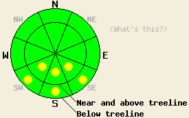
Click here to see the full forecast for 2011-11-19 |
November 19, 2011 at 16:47 Near and above treeline avalanche danger is MODERATE both above and below treeline in areas above 8,000' on NW-N-NE-E aspects on slopes 32 degrees and steeper. For all other areas, avalanche danger is LOW. Avalanche danger is expected to increase during the overnight hours with natural avalanches becoming possible. |
 |
|
Click here to see the full forecast for 2011-11-18 |
November 18, 2011 at 14:31 Early Season Conditions Update #3 Daily avalanche advisories are planned to resume in mid November or later as conditions dictate. Occasional intermittent early season updates to this page will occur earlier as conditions warrant. |
|
|
Click here to see the full forecast for 2011-11-10 |
November 10, 2011 at 9:41 Early Season Conditions Update #2 Daily avalanche advisories are planned to resume in mid November or later as conditions dictate. Occasional intermittent early season updates to this page will occur earlier as conditions warrant. |
|
|
Click here to see the full forecast for 2011-11-04 |
November 4, 2011 at 8:05 Early Season Conditions Update #1 Daily avalanche advisories are planned to resume in mid November or later as conditions dictate. Occasional intermittent early season updates to this page will occur earlier as conditions warrant.
|
|
|
Click here to see the full forecast for 2011-10-04 |
October 4, 2011 at 8:39 Fall Avalanche Statement Daily avalanche advisories are planned to resume in mid November or later as conditions dictate. Occasional intermittent early season updates to this page may occur earlier if conditions warrant and resources are available. |
|
|
Click here to see the full forecast for 2011-04-23 |
April 23, 2011 at 22:17 We have stopped issuing daily avalanche advisories until the fall of 2011. The avalanche danger can and will change quickly during this spring. Continue to monitor changing conditions and use caution when traveling in the backcountry. For general spring avalanche information read the full spring avalanche statement. |
|
|
Click here to see the full forecast for 2011-04-23 |
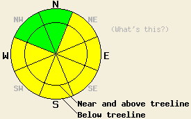
April 23, 2011 at 6:36 Today the avalanche danger should remain LOW for all elevations and aspects due to light winds, little new snow accumulation, increased cloud cover, and cooler temperatures. Large, dangerous avalanche activity will remain unlikely but not impossible. This will be the last advisory of the 2010-2011 winter. The observations pages will remain active so please continue to share your backcountry observations here: snowpack obs, avalanche obs. Thanks to everyone who makes the avalanche center possible. |
 |
|
Click here to see the full forecast for 2011-04-22 |
April 22, 2011 at 6:41 Early this morning, avalanche danger is LOW for all elevations and aspects. Pockets of MODERATE danger will form at all elevations on NE-E-SE-S-SW-W aspects on slopes 35 degrees and steeper in response to daytime warming. |
 |
|
Click here to see the full forecast for 2011-04-21 |
April 21, 2011 at 6:42 Near and above treeline, avalanche danger is MODERATE above 7,500' on NW-N-NE-E-SE aspects on slopes 35 degrees and steeper. For all other areas, pockets of MODERATE danger exist on all aspects at all elevations on slopes 35 degrees and steeper. |
 |
|
Click here to see the full forecast for 2011-04-20 |
April 20, 2011 at 6:51 Areas of MODERATE avalanche danger are expected at nearly all elevations on E-SE-S-SW-W aspects on slopes 35 degrees and steeper. Pockets of MODERATE danger are expected on NW-N-NE aspects below 8,500' on slopes 35 degrees and steeper. |
 |
|
Click here to see the full forecast for 2011-04-19 |
April 19, 2011 at 7:00 Areas of MODERATE avalanche danger should form on E-SE-S-SW-W aspects at all elevations today due to daytime warming. Small pockets of MODERATE danger may also form on NW-N-NE aspects near and above treeline north of Hwy 50 where new snow exists as the day warms up. |
 |
|
Click here to see the full forecast for 2011-04-18 |
April 18, 2011 at 6:49 Near and above treeline, MODERATE avalanche danger exists on wind-loaded NW-N-NE-E-SE aspects above 8000 ft. Below 8000 ft. pockets of MODERATE avalanche danger should exist on all aspects due to continued rain on snow. In areas south of Hwy 50 where less precipitation has fallen, the avalanche danger should be less widespread. |
 |
|
Click here to see the full forecast for 2011-04-17 |
April 17, 2011 at 7:00 This morning the avalanche danger is LOW for all elevations and aspects. Pockets of MODERATE avalanche danger should form on all aspects due to daytime warming and rain this afternoon and tonight. As the rain showers increase this evening and tonight, wet snow instabilities will become more widespread. |
 |
|
Click here to see the full forecast for 2011-04-16 |
April 16, 2011 at 7:00 The avalanche danger should remain LOW for all elevations and aspects today. Some minor wet snow instabilities could form due to daytime warming. Larger wet snow instabilities and wet slab avalanches will remain unlikely today but not impossible. |
 |
|
Click here to see the full forecast for 2011-04-15 |
April 15, 2011 at 6:59 Early this morning, avalanche danger is LOW for all elevations and aspects. Isolated areas of MODERATE danger may form today both above and below treeline on NE-E-SE-S aspects on slopes 35 degrees and steeper in response to daytime warming, especially in the southern portion of the forecast area. |
 |
|
Click here to see the full forecast for 2011-04-14 |
April 14, 2011 at 6:57 Early this morning, avalanche danger is LOW for all elevations and aspects. Avalanche danger will rise to MODERATE in sun exposed areas both above and below treeline on NE-E-SE-S-SW-W aspects on slopes 35 degrees and steeper in response to daytime warming. |
 |
|
Click here to see the full forecast for 2011-04-13 |
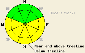
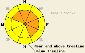
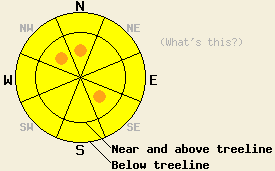
April 13, 2011 at 6:41 Avalanche danger is LOW for all elevations and aspects. Normal caution is advised. |
 |
|
Click here to see the full forecast for 2011-04-12 |
April 12, 2011 at 6:58 This morning, avalanche danger is LOW for all elevations and aspects. MODERATE avalanche danger may form on open, sun-exposed E-SE-S-SW-W aspects on slopes 35 degrees and steeper as the day warms up. |
 |
|
Click here to see the full forecast for 2011-04-11 |
April 11, 2011 at 6:42 This morning, avalanche danger is LOW for all elevations and aspects. MODERATE avalanche danger may form on open, sun-exposed E-SE-S-SW-W aspects on slopes 35 degrees and steeper as the day warms up. |
 |
|
Click here to see the full forecast for 2011-04-10 |
April 10, 2011 at 6:49 This morning, avalanche danger is LOW for all elevations and aspects. MODERATE avalanche danger may form on open, sun-exposed E-SE-S-SW-W aspects on slopes 35 degrees and steeper as the day warms up. |
 |
|
Click here to see the full forecast for 2011-04-09 |
April 9, 2011 at 6:34 Early this morning, avalanche danger is LOW for all elevations and aspects. Isolated pockets of MODERATE danger are expected to form on open sun exposed E-SE-S-SW-W aspects on slopes 37 degrees and steeper in response to daytime warming. |
 |
|
Click here to see the full forecast for 2011-04-08 |
April 8, 2011 at 6:45 Near and above treeline, avalanche danger is LOW with pockets of MODERATE danger on all aspects on slopes 37 degrees and steeper. Below treeline, avalanche danger is LOW. |
 |
|
Click here to see the full forecast for 2011-04-07 |
April 7, 2011 at 6:52 Near and above treeline avalanche danger is CONSIDERABLE on NW-N-NE-E-SE aspects, on slopes 35 degrees and steeper. For all other areas above and below treeline, avalanche danger is MODERATE on all aspects on slopes 35 degrees and steeper. |
 |
|
Click here to see the full forecast for 2011-04-06 |
April 6, 2011 at 6:55 The avalanche danger should remain LOW for most areas today. Some isolated pockets of MODERATE avalanche danger may form on the most sun-exposed, lower elevation E-SE-S-SW aspects on slopes 37 degrees and steeper as the day warms up. As snow and wind impact the forecast area tonight the avalanche danger will quickly increase and become more widespread. |
 |
|
Click here to see the full forecast for 2011-04-05 |
April 5, 2011 at 6:44 Early this morning, avalanche danger is LOW for all elevations and aspects. MODERATE avalanche danger will form on E-SE-S-SW-W aspects on slopes 35 degrees and steeper as the day warms up. |
 |
|
Click here to see the full forecast for 2011-04-04 |
April 4, 2011 at 7:00 Early this morning, avalanche danger is LOW for all elevations and aspects. MODERATE avalanche danger will form on E-SE-S-SW-W aspects on slopes 35 degrees and steeper as the day warms up. |
 |
|
Click here to see the full forecast for 2011-04-03 |
April 3, 2011 at 6:20 Early this morning, avalanche danger is LOW for all elevations and aspects. Pockets of MODERATE danger will form in response to daytime warming on E-SE-S-SW-W aspects on slopes 37 degrees and steeper. |
 |
|
Click here to see the full forecast for 2011-04-02 |
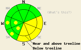
April 2, 2011 at 6:46 Avalanche danger is MODERATE with pockets of CONSIDERABLE danger below 8,000' on NE-E-SE-S aspects on slopes 35 degrees and steeper. For all other areas, avalanche danger is MODERATE at all elevations on slopes 35 degrees and steeper. |
 |
|
Click here to see the full forecast for 2011-04-01 |
April 1, 2011 at 6:30 On E-SE-S aspects avalanche danger is MODERATE with pockets of CONSIDERABLE danger forming today at all elevations on slopes 35 degrees and steeper. On SW-W aspects avalanche danger is MODERATE at all elevations on slopes 35 degrees and steeper. On NW-N-NE aspects, avalanche danger is LOW with pockets of MODERATE danger forming at all elevations on slopes 35 degrees and steeper. |
 |
|
Click here to see the full forecast for 2011-03-31 |
March 31, 2011 at 7:00 This morning, avalanche danger is LOW for all elevations and aspects. MODERATE avalanche danger will quickly form on E-SE-S-SW-W aspects at all elevations on slopes 35 degrees and steeper due to daytime warming. Large dangerous natural and human-triggered cornice collapses also remain likely today. |
 |
|
Click here to see the full forecast for 2011-03-30 |
March 30, 2011 at 7:01 Early this morning, avalanche danger is LOW for all elevations and aspects. MODERATE danger quickly will form on E-SE-S aspects with pockets of MODERATE danger forming on SW-W aspects at all elevations on slopes 37 degrees and steeper due to daytime warming. Even though human-triggered and natural avalanches remain unlikely, large dangerous natural and human-triggered cornice collapses remain likely. |
 |
|
Click here to see the full forecast for 2011-03-29 |
March 29, 2011 at 6:45 Early this morning, avalanche danger is LOW for all elevations and aspects. As daytime warming occurs, areas of MODERATE danger will form on E-SE-S aspects at all elevations on slopes 37 degrees and steeper. For all other areas, avalanche danger will remain LOW. The greatest areas of instability today are expected to form in the southern portion of the forecast area. |
 |
|
Click here to see the full forecast for 2011-03-28 |
March 28, 2011 at 6:57 Avalanche danger is MODERATE both above and below treeline on E-SE-S aspects on slopes 35 degrees and steeper. For all other areas avalanche danger is LOW. Please keep in mind that LOW danger does not mean no danger. There is a significant difference between the terms "unlikely" and "impossible". |
 |
|
Click here to see the full forecast for 2011-03-27 |
March 27, 2011 at 6:58 Near and above treeline, avalanche danger is MODERATE on NW-N-NE-E-SE aspects on slopes 35 degrees and steeper. Below treeline, avalanche danger is LOW with pockets of MODERATE danger on all aspects in open areas on slopes 37 degrees and steeper. |
 |
|
Click here to see the full forecast for 2011-03-26 |
March 26, 2011 at 6:50 Near and above treeline, avalanche danger is CONSIDERABLE on NW-N-NE-E-SE-S aspects on slopes 35 degrees and steeper. Below treeline avalanche danger is MODERATE with pockets of CONSIDERABLE danger on NW-N-NE-E-SE-S aspects on slopes 35 degrees and steeper. On the SW-W aspects avalanche danger is MODERATE both above and below treeline on slopes 35 degrees and steeper. Large and destructive avalanches remain possible. The best window for natural avalanche activity will occur during the morning hours. Human triggered avalanches will remain possible to likely all day long. |
 |
|
Click here to see the full forecast for 2011-03-25 |
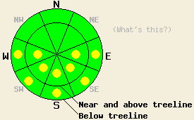
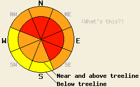
March 25, 2011 at 7:00 Near and above treeline, the avalanche danger will remain HIGH on NW-N-NE-E-SE aspects on slopes steeper than 35 degrees. Below treeline the avalanche danger is CONSIDERABLE on NW-N-NE-E-SE aspects on slopes steeper than 35 degrees. On the S-SW-W aspects the avalanche danger will remain CONSIDERABLE above treeline and MODERATE below treeline on slopes steeper than 35 degrees. Large natural and human-triggered avalanche will remain likely today. |
 |
|
Click here to see the full forecast for 2011-03-24 |
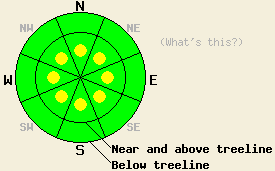
March 24, 2011 at 7:00 The avalanche danger will rise to HIGH on NW-N-NE-E-SE aspects on slopes steeper than 35 degrees at all elevations today and tonight. On the S-SW-W aspects the avalanche danger will reach CONSIDERABLE on slopes steeper than 35 degrees. Large natural and human-triggered avalanche will become likely due to to strong winds and intense snowfall during the next 24 hours. |
 |
|
Click here to see the full forecast for 2011-03-23 |
March 23, 2011 at 7:00 Near and above treeline, CONSIDERABLE avalanche danger will form on NW-N-NE-E-SE aspects on slopes steeper than 35 degrees today. Below treeline pockets of CONSIDERABLE avalanche danger will form on these aspects on slopes steeper than 35 degrees. On the S-SW-W aspects the avalanche danger is MODERATE on slopes steeper than 35 degrees. |
 |
|
Click here to see the full forecast for 2011-03-22 |
March 22, 2011 at 6:52 Avalanche danger is MODERATE for all elevations and aspects on slopes 35 degrees and steeper today due to a combination of recent wind loading and warming instability. Small to medium size human triggered avalanches remain possible today in a variety of areas. Large human triggered avalanches remain possible in isolated areas. Increasing avalanche danger is expected tonight into Wednesday. |
 |
|
Click here to see the full forecast for 2011-03-21 |
March 21, 2011 at 7:00 Near and above treeline, avalanche danger is MODERATE with isolated pockets of CONSIDERABLE danger on NW-N-NE-E-SE aspects on slopes 35 degrees and steeper. Below treeline, avalanche danger is MODERATE on all aspects on slopes 35 degrees and steeper. Large destructive avalanches remain possible. Human triggered avalanches are expected today and should not be of surprise to backcountry travelers. |
 |
|
Click here to see the full forecast for 2011-03-20 |
March 20, 2011 at 7:00 Near and above treeline, avalanche danger is HIGH on NW-N-NE-E-SE aspects, 35 degrees and steeper. Below treeline, avalanche danger is CONSIDERABLE in open areas on all aspects, 35 degrees and steeper. |
 |
|
Click here to see the full forecast for 2011-03-19 |
March 19, 2011 at 7:02 Near and above treeline, CONSIDERABLE avalanche danger exists on NW-N-NE-E-SE aspects steeper than 35 degrees. Below treeline on slopes steeper than 35 degress, pockets of CONSIDERABLE danger exist on those aspects. On the S-SW-W aspects, at all elevations the avalanche danger is MODERATE. Large, deep, and destructive avalanches could occur today. |
 |
|
Click here to see the full forecast for 2011-03-18 |
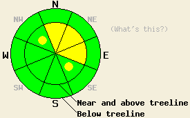
March 18, 2011 at 7:01 Near and above treeline by this afternoon, MODERATE avalanche danger will form on NW-N-NE-E aspects steeper than 35 degrees with pockets of MODERATE danger on the SE aspects. Below treeline the avalanche danger should remain LOW during the day today. As the winter storm impacts the forecast area, CONSIDERABLE avalanche danger will develop in areas at all elevations tonight. If the storm arrives sooner than expected, the areas of CONSIDERABLE danger will form sooner. |
 |
|
Click here to see the full forecast for 2011-03-17 |
March 17, 2011 at 7:00 Near and above treeline on slopes steeper than 35 degrees, MODERATE avalanche danger exists on N-NE-E aspects with pockets of MODERATE danger on all other aspects. Below treeline on open slopes steeper than 35 degrees, MODERATE danger exists on sun-exposed SE-S-SW aspects with pockets of MODERATE danger on other aspects. |
 |
|
Click here to see the full forecast for 2011-03-16 |
March 16, 2011 at 6:53 Near and above treeline, avalanche danger is CONSIDERABLE on NW-N-NE-E-SE aspects, on slopes 35 degrees and steeper. Below treeline, avalanche danger is MODERATE in open areas, on slopes 35 degrees and steeper. Large destructive avalanches are possible. |
 |
|
Click here to see the full forecast for 2011-03-15 |
March 15, 2011 at 6:51 For all aspects and elevations, avalanche danger is MODERATE with pockets of CONSIDERABLE danger forming this afternoon on slopes 35 degrees and steeper. Continued increasing avalanche danger will occur tonight. |
 |
|
Click here to see the full forecast for 2011-03-14 |
March 14, 2011 at 6:45 Near and above treeline avalanche danger is MODERATE with pockets of CONSIDERABLE danger on NE-E-SE-S aspects, on slopes 35 degrees and steeper. Below treeline, avalanche danger is MODERATE on all aspects on slopes 35 degrees and steeper. |
 |
|
Click here to see the full forecast for 2011-03-13 |
March 13, 2011 at 7:00 Near and above treeline, avalanche danger is LOW with very isolated pockets of MODERATE danger on N-NE-E aspects on slopes 37 degrees and steeper. Below treeline LOW avalanche danger exists on all aspects. As more snow and wind impact the region tonight the avalanche danger will quickly increase. |
 |
|
Click here to see the full forecast for 2011-03-12 |
March 12, 2011 at 8:00 Near and above treeline, avalanche danger is LOW with pockets of MODERATE danger on NW-N-NE-E-SE aspects on slopes 37 degrees and steeper. Below treeline LOW avalanche danger exists on all aspects. |
 |
|
Click here to see the full forecast for 2011-03-11 |
March 11, 2011 at 8:00 Near and above treeline, avalanche danger is LOW with pockets of MODERATE danger on NW-N-NE-E-SE aspects on slopes 35 degrees and steeper. Below treeline LOW avalanche danger exists on all aspects. If more sunshine and daytime warming than forecasted occurs today, the avalanche danger will increase on sun-exposed aspects at all elevations. |
 |
|
Click here to see the full forecast for 2011-03-10 |
March 10, 2011 at 7:33 Near and above treeline, avalanche danger is LOW with pockets of MODERATE danger on N-NE-E aspects on slopes 37 degrees and steeper. Elsewhere, avalanche danger is LOW. If snowfall amounts this afternoon exceed forecast expectations, avalanche danger will be greater and more widespread. |
 |
|
Click here to see the full forecast for 2011-03-09 |
March 9, 2011 at 7:40 Both above and below treeline, avalanche danger is MODERATE on E-SE-S-SW-W aspects on slopes 35 degrees and steeper. Avalanche danger on NW-N-NE aspects is LOW with pockets of MODERATE danger both above and below treeline. |
 |
|
Click here to see the full forecast for 2011-03-08 |
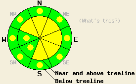
March 8, 2011 at 7:55 Near and above treeline, avalanche danger is MODERATE on all aspects on slopes 35 degrees and steeper. Below treeline, avalanche danger is MODERATE on E-SE-S-SW-W aspects 35 degrees and steeper. On NW-N-NE aspects below treeline, avalanche danger is LOW with pockets of MODERATE danger on slopes 37 degrees and steeper. |
 |
|
Click here to see the full forecast for 2011-03-07 |
March 7, 2011 at 8:03 Near and above treeline pockets of CONSIDERABLE avalanche danger exist on N-NE-E-SE aspects on slopes 35 degrees and steeper. MODERATE danger exists on other near and above treeline aspects. Below treeline pockets of MODERATE avalanche danger will exist on any slopes steeper than 35 degrees. |
 |
|
Click here to see the full forecast for 2011-03-06 |
March 6, 2011 at 8:00 Near and above treeline pockets of CONSIDERABLE avalanche danger may form today on N-NE-E-SE aspects on slopes 35 degrees and steeper. MODERATE danger exists on other near and above treeline aspects. Below treeline pockets of CONSIDERABLE avalanche danger will exist on any slopes steeper than 35 degrees that receive rain today. |
 |
|
Click here to see the full forecast for 2011-03-05 |
March 5, 2011 at 8:00 Pockets of MODERATE avalanche danger may form today on SE-S-SW aspects on slopes 37 degrees and steeper in response to daytime warming at all elevations. On the more northerly aspects, LOW avalanche danger exists at all elevations. LOW danger does not mean that avalanche activity is impossible. Continue to use caution when traveling in the backcountry. |
 |
|
Click here to see the full forecast for 2011-03-04 |
March 4, 2011 at 7:41 Near and above treeline, areas of MODERATE danger will form today on SE-S-SW aspects on slopes 37 degrees and steeper in response to daytime warming. Pockets of MODERATE danger exist near and above treeline on NW-N-NE-E aspects 35 degrees and steeper due to lingering storm snow instabilities. Below treeline areas of MODERATE danger will form today on SE-S-SW aspects on slopes 37 degrees and steeper in response to daytime warming. Elsewhere, avalanche danger is LOW. |
 |
|
Click here to see the full forecast for 2011-03-03 |
March 3, 2011 at 7:55 Near and above treeline avalanche danger is MODERATE with pockets of CONSIDERABLE danger on N-NE-E aspects on slopes 35 degrees and steeper. Below treeline avalanche danger is MODERATE on all aspects on slopes 35 degrees and steeper. |
 |
|
Click here to see the full forecast for 2011-03-02 |
March 2, 2011 at 7:56 West of Hwy 89, avalanche danger near and above treeline is MODERATE with isolated pockets of CONSIDERABLE danger forming today on N-NE-E aspects on slopes 35 degrees and steeper. Below treeline, avalanche danger is LOW with pockets of MODERATE danger on all aspects on slopes 35 degrees and steeper. East of Hwy 89 avalanche danger is LOW with pockets of MODERATE danger forming today in wind loaded areas near and above treeline on N-NE-E aspects on slopes 35 degrees and steeper. |
 |
|
Click here to see the full forecast for 2011-03-01 |
March 1, 2011 at 7:59 Near and above treeline, very isolated pockets of MODERATE avalanche danger exist on NW-N-NE-E-SE aspects, 37 degrees and steeper. Below treeline, pockets of MODERATE avalanche danger may form on the most sun-exposed SE-S-SW aspects 35 degrees and steeper due to daytime warming. |
 |
|
Click here to see the full forecast for 2011-02-28 |
February 28, 2011 at 8:00 Near and above treeline, pockets of MODERATE avalanche danger will exist on all aspects, 35 degrees and steeper. Below treeline, avalanche danger is MODERATE on SE-S-SW aspects with pockets of MODERATE danger on E and W aspects, 35 degrees and steeper. Deep and destructive human triggered avalanches remain possible. |
 |
|
Click here to see the full forecast for 2011-02-27 |
February 27, 2011 at 8:00 Near and above treeline, pockets of MODERATE avalanche danger will exist on all aspects, 35 degrees and steeper. Below treeline, avalanche danger is MODERATE on SE-S-SW aspects with pockets of MODERATE danger on E and W aspects, 35 degrees and steeper. Deep and destructive human triggered avalanches remain possible. |
 |
|
Click here to see the full forecast for 2011-02-26 |
February 26, 2011 at 8:02 Near and above treeline, avalanche danger is MODERATE with pockets of CONSIDERABLE danger on cross loaded NW, N, and SE aspects, 35 degrees and steeper. Below treeline, avalanche danger is MODERATE on all aspects, 35 degrees and steeper. Large human triggered avalanches remain possible. |
 |
|
Click here to see the full forecast for 2011-02-25 |
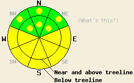
February 25, 2011 at 7:53 Near and above treeline, avalanche danger is HIGH on NW-N-NE-E-SE aspects 32 degrees and steeper. Below treeline avalanche danger is CONSIDERABLE on all aspects on slopes 35 degrees and steeper. Large destructive avalanches are likely today. |
 |
|
Click here to see the full forecast for 2011-02-24 |
February 24, 2011 at 7:47 Near and above treeline, avalanche danger is MODERATE on N-NE-E aspects, 35 degrees and steeper. Pockets of MODERATE danger exist on NW and SE aspects, 35 degrees and steeper. Below treeline, avalanche danger remains LOW for all elevations and aspects. Human triggered avalanches ranging from small to large in size are possible today. A significant increase in avalanche danger is expected to occur this evening, continuing overnight and through the day on Friday. Areas of CONSIDERABLE avalanche danger may form prior to sunset today in wind loaded areas with human triggered avalanches becoming likely and natural avalanches possible. |
 |
|
Click here to see the full forecast for 2011-02-23 |
February 23, 2011 at 7:58 Near and above treeline on slopes steeper than 35 degrees, MODERATE avalanche danger remains on wind-loaded N-NE-E aspects with pockets MODERATE danger on cross-loaded NW and SE aspects. Below treeline avalanche danger is LOW. Large human triggered avalanches remain possible. |
 |
|
Click here to see the full forecast for 2011-02-22 |
February 22, 2011 at 7:56 Near and above treeline on slopes steeper than 35 degrees, MODERATE avalanche danger remains on wind-loaded N-NE-E aspects with pockets MODERATE danger on cross-loaded NW and SE aspects. Below treeline avalanche danger is LOW. Large human triggered avalanches remain possible. |
 |
|
Click here to see the full forecast for 2011-02-20 |
February 20, 2011 at 8:00 Near and above treeline, avalanche danger is MODERATE on recently wind loaded NW-N-NE-E-SE-S aspects 35 degrees and steeper. Isolated pockets of MODERATE danger may exist on SW-W aspects as well. Below treeline avalanche danger is LOW with pockets of MODERATE danger in open wind affected areas on all aspects, 35 degrees and steeper. Large human triggered avalanches remain possible. |
 |
|
Click here to see the full forecast for 2011-02-19 |
February 19, 2011 at 7:53 Near and above treeline, avalanche danger is MODERATE with pockets of CONSIDERABLE danger on NW-N-NE-E-SE aspects, 35 degrees and steeper. Below treeline, avalanche danger is MODERATE on all aspects, 35 degrees and steeper. Large destructive avalanches are possible. |
 |
|
Click here to see the full forecast for 2011-02-18 |
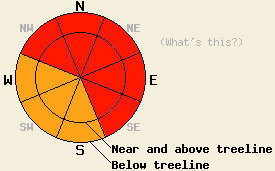
February 18, 2011 at 7:52 Near and above treeline, avalanche danger is HIGH on NW-N-NE-E-SE aspects, 35 degrees and steeper. Below treeline, avalanche danger is CONSIDERABLE on all aspects on slopes 35 degrees and steeper. |
 |
|
Click here to see the full forecast for 2011-02-17 |
February 17, 2011 at 7:59 Near and above treeline on slopes steeper than 35 degrees, CONSIDERABLE avalanche danger exists on the NW-N-NE-E-SE aspects. Below treeline on slopes steeper than 35 degrees, MODERATE avalanche danger exists on all aspects with pockets of CONSIDERABLE danger on NW-N-NE-E-SE aspects on slopes steeper than 37 degrees. |
 |
|
Click here to see the full forecast for 2011-02-16 |
February 16, 2011 at 8:00 Near and above treeline on slopes steeper than 35 degrees, CONSIDERABLE avalanche danger exists on the NW-N-NE-E-SE aspects. Below treeline on slopes steeper than 35 degrees, MODERATE avalanche danger exists on all aspects with pockets of CONSIDERABLE danger on the NW-N-NE-E-SE aspects. |
 |
|
Click here to see the full forecast for 2011-02-15 |
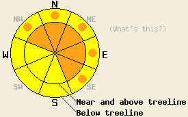
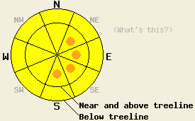
February 15, 2011 at 7:51 In most areas the avalanche danger remains LOW. Some isolated pockets of MODERATE avalanche danger may exist on the wind-loaded N-NE-E aspects near and above treeline 35 degrees and steeper. The avalanche danger will increase quickly and dramatically as a strong winter storm impacts the region this evening. |
 |
|
Click here to see the full forecast for 2011-02-14 |
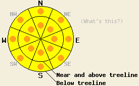
February 14, 2011 at 7:41 Avalanche danger remains LOW for all elevations and aspects. Normal caution is advised. |
 |
|
Click here to see the full forecast for 2011-02-13 |
February 13, 2011 at 8:01 Avalanche danger remains LOW on all elevations and aspects. Normal caution is advised. |
 |
|
Click here to see the full forecast for 2011-02-12 |
February 12, 2011 at 7:37 Avalanche danger remains LOW on all elevations and aspects. Normal caution is advised. |
 |
|
Click here to see the full forecast for 2011-02-11 |
February 11, 2011 at 7:49 The avalanche danger should remain LOW on all elevations and aspects today. Please use normal caution while traveling in the backcountry. |
 |
|
Click here to see the full forecast for 2011-02-10 |
February 10, 2011 at 7:56 LOW avalanche danger exists on all elevations and aspects. Please use normal caution while traveling in the backcountry. |
 |
|
Click here to see the full forecast for 2011-02-09 |
February 9, 2011 at 7:56 The avalanche danger remains LOW for all elevations and aspects. Please use normal caution while traveling in the backcountry. |
 |
|
Click here to see the full forecast for 2011-02-08 |
February 8, 2011 at 7:47
Avalanche danger is LOW for all elevations and aspects. Normal caution is advised.
|
 |
|
Click here to see the full forecast for 2011-02-07 |
February 7, 2011 at 7:32 Avalanche danger is LOW for all elevations and aspects. Normal caution is advised. |
 |
|
Click here to see the full forecast for 2011-02-06 |
February 6, 2011 at 7:46 Avalanche danger is LOW for all elevations and aspects. Normal caution is advised. |
 |
|
Click here to see the full forecast for 2011-02-05 |
February 5, 2011 at 7:53 LOW avalanche danger exists on all aspects and elevations. Use normal caution when traveling in the backcountry. |
 |
|
Click here to see the full forecast for 2011-02-04 |
February 4, 2011 at 8:00 LOW avalanche danger exists on most aspects and elevations. Some very isolated pockets of MODERATE danger may exist on NW-N-NE aspects, 37 degrees and steeper near treeline. |
 |
|
Click here to see the full forecast for 2011-02-03 |
February 3, 2011 at 8:03 LOW avalanche danger exists on most aspects and elevations. Some very isolated pockets of MODERATE danger may remain on SE-S-SW-W-NW aspects, 37 degrees and steeper near and above treeline. |
 |
|
Click here to see the full forecast for 2011-02-02 |
February 2, 2011 at 7:48 For most locations near and above treeline avalanche danger is LOW. Very isolated pockets of MODERATE danger may exist near and above treeline on SE-S-SW-W-NW aspects, 37 degrees and steeper. Below treeline, avalanche danger is LOW for all elevations and aspects. |
 |
|
Click here to see the full forecast for 2011-02-01 |
February 1, 2011 at 7:51 Near and above treeline, avalanche danger is LOW with pockets of MODERATE danger on SE-S-SW-W-NW-N aspects, 37 degrees and steeper. Below treeline, avalanche danger is LOW. |
 |
|
Click here to see the full forecast for 2011-01-31 |
January 31, 2011 at 8:00 Near and above treeline, pockets of MODERATE avalanche danger exist on all aspects on slopes 35 degrees and steeper. Below treeline, avalanche danger is LOW with pockets of MODERATE danger on N-NE-E aspects 37 degrees and steeper. Human triggered avalanches remain possible today in a variety of areas. Use good travel habits to minimize risk. |
 |
|
Click here to see the full forecast for 2011-01-30 |
January 30, 2011 at 8:00 Near and above treeline on slopes steeper than 35 degrees, MODERATE avalanche danger exists on NW-N-NE-E-SE aspects with pockets of MODERATE danger on the S-SW-W aspects. Some pockets of CONSIDERABLE danger may form on the most wind-loaded N-NE-E aspects along the Sierra Crest. Below treeline on slopes steeper than 35 degrees, pockets of MODERATE danger exist on all aspects. |
 |
|
Click here to see the full forecast for 2011-01-29 |
January 29, 2011 at 8:01 The avalanche danger should remain LOW for all elevations and aspects for most of the day. Use normal caution when traveling in the backcountry. |
 |
|
Click here to see the full forecast for 2011-01-28 |
January 28, 2011 at 8:01 The avalanche danger should remain LOW for all elevations and aspects for most of the day. Pockets of MODERATE danger may form this afternoon on SE-S-SW aspects 35 degrees and steeper in response to daytime warming. |
 |


This website is owned and maintained by the non-profit arm of the Sierra Avalanche Center. Some of the content is updated by the USDA avalanche forecasters including the forecasts and some observational data. The USDA is not responsible for any advertising, fund-raising events/information, or sponsorship information, or other content not related to the forecasts and the data pertaining to the forecasts.

