

The last avalanche forecast for the 2023-2024 season posted on April 21st. Thank you to all who contributed to the avalanche center this season through observations, volunteer time, and/or financial contributions.
In partnership with: 
The last avalanche forecast for the 2023-2024 season posted on April 21st. Thank you to all who contributed to the avalanche center this season through observations, volunteer time, and/or financial contributions.
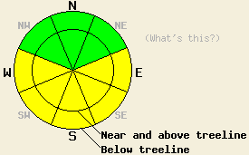
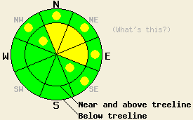
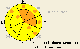
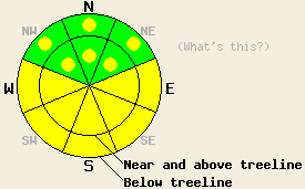
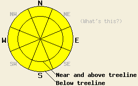
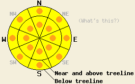
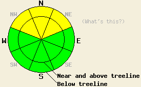
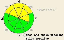
Use this page to view archived advisories. The table below shows the overall danger rating and the bottom line for the 20 most recent advisories. Click on the time and date link above each danger rating icon to view the full advisory for that day. Use the date chooser or the pager at the bottom to scroll through the older advisories.
|
Date the forecast was published: |
Bottom Line | |
|---|---|---|
|
Click here to see the full forecast for 2012-02-03 |
February 3, 2012 at 7:41 Avalanche danger remains LOW for all elevations and aspects. Normal caution is advised. |
 |
|
Click here to see the full forecast for 2012-02-04 |
February 4, 2012 at 7:41 Avalanche danger remains LOW for all elevations and aspects. Normal caution is advised. |
 |
|
Click here to see the full forecast for 2012-02-05 |
February 5, 2012 at 8:00 Avalanche danger remains LOW for all elevations and aspects. Use normal caution when traveling in the backcountry. |
 |
|
Click here to see the full forecast for 2012-02-06 |
February 6, 2012 at 8:00 Avalanche danger remains LOW for all elevations and aspects. Use normal caution when traveling in the backcountry. |
 |
|
Click here to see the full forecast for 2012-02-07 |
February 7, 2012 at 7:56 Avalanche danger remains LOW for all elevations and aspects. Use normal caution when traveling in the backcountry. |
 |
|
Click here to see the full forecast for 2012-02-08 |
February 8, 2012 at 7:46 Avalanche danger remains LOW for all elevations and aspects. Normal caution is advised. |
 |
|
Click here to see the full forecast for 2012-02-09 |
February 9, 2012 at 7:41 Avalanche danger remains LOW for all elevations and aspects. Normal caution is advised. |
 |
|
Click here to see the full forecast for 2012-02-10 |
February 10, 2012 at 7:45 Avalanche danger remains LOW for all elevations and aspects. Normal caution is advised. |
 |
|
Click here to see the full forecast for 2012-02-11 |
February 11, 2012 at 8:00 Avalanche danger remains LOW for all elevations and aspects. Use normal caution when traveling in the backcountry. |
 |
|
Click here to see the full forecast for 2012-02-12 |
February 12, 2012 at 8:00 Avalanche danger remains LOW for all elevations and aspects. Use normal caution when traveling in the backcountry. As more snow and wind impact the forecast area late tonight through tomorrow, the avalanche danger will increase. |
 |
|
Click here to see the full forecast for 2012-02-13 |
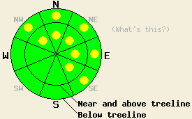
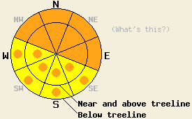
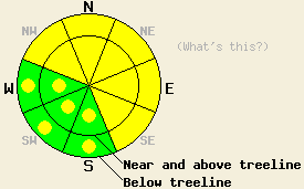
February 13, 2012 at 8:00 MODERATE avalanche danger exists near and above treeline on the NW-N-NE-E-SE aspects on slopes steeper than 35 degrees. Pockets of MODERATE danger exist on the NW-N-NE-E-SE aspects on slopes steeper than 35 degrees below treeline. MODERATE danger means that human-triggered avalanches are possible today. |
 |
|
Click here to see the full forecast for 2012-02-14 |
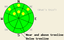
February 14, 2012 at 7:55 Avalanche danger is LOW for all elevations and aspects. Normal caution is advised. Small avalanches are unlikely but not impossible in isolated areas or in extreme terrain. |
 |
|
Click here to see the full forecast for 2012-02-15 |
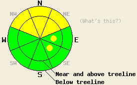
February 15, 2012 at 7:55 Near and above treeline, avalanche danger is LOW with pockets of MODERATE danger in wind loaded areas on all aspects on slopes 35 degrees and steeper. Below treeline, avalanche danger is LOW with isolated pockets of MODERATE danger in wind affected areas on NW-N-NE-E aspects on slopes 35 degrees and steeper. |
 |
|
Click here to see the full forecast for 2012-02-16 |
February 16, 2012 at 8:00 Generally LOW avalanche danger exists today. Very isolated pockets of MODERATE danger may linger near treeline and below treeline on N-NE aspects on slopes 35 degrees and steeper due to persistent slabs. On SE-S-SW-W aspects, minor warming instability may form today on recently wind loaded SE-S-SW-W aspects on slopes 37 degrees and steeper. |
 |
|
Click here to see the full forecast for 2012-02-16 |
February 16, 2012 at 8:04 Generally LOW avalanche danger exists today. Very isolated pockets of MODERATE danger may linger near treeline and below treeline on N-NE aspects on slopes 35 degrees and steeper due to persistent slabs. On SE-S-SW-W aspects, minor warming instability may form today on recently wind loaded SE-S-SW-W aspects on slopes 37 degrees and steeper. |
 |
|
Click here to see the full forecast for 2012-02-17 |
February 17, 2012 at 8:00 On slopes steeper than 34 degrees, MODERATE avalanche danger will exist on NW-N-NE aspects in both above and below treeline terrain due to a persistent weak layer near the base of the recent snow. Some isolated pockets of MODERATE danger may also exist on the shaded and sheltered E aspects. On SE-S-SW-W aspects pockets of MODERATE danger may form due to daytime warming on slopes 37 degrees and steeper. |
 |
|
Click here to see the full forecast for 2012-02-18 |
February 18, 2012 at 8:00 On slopes steeper than 34 degrees, MODERATE avalanche danger will persist on NW-N-NE aspects in both above and below treeline terrain due to a persistent weak layer near the base of the recent snow. Some isolated pockets of MODERATE danger may also exist on the shaded and sheltered E aspects. Human-triggered avalanches remain possible in these areas. |
 |
|
Click here to see the full forecast for 2012-02-19 |
February 19, 2012 at 8:01 On slopes steeper than 35 degrees, pockets of MODERATE avalanche danger will persist on NW-N-NE aspects in both above and below treeline terrain due to a persistent weak layer near the base of the recent snow. Human-triggered avalanches remain possible in these areas today. |
 |
|
Click here to see the full forecast for 2012-02-20 |
February 20, 2012 at 7:48 Pockets of MODERATE avalanche danger persist near treeline and below treeline on NW-N-NE aspects on slope 35 degrees and steeper due to a persistent weak layer at the base of the recent new snow. For all other areas, avalanche danger is LOW. |
 |
|
Click here to see the full forecast for 2012-02-21 |
February 21, 2012 at 7:49 Avalanche danger is LOW for all elevations and aspects. Human triggered avalanches are unlikely but not impossible due to a persistent weak layer near treeline and below treeline on NW-N-NE aspects. |
 |
|
Click here to see the full forecast for 2012-02-22 |
February 22, 2012 at 7:39 Avalanche danger is LOW for all elevations and aspects. Minor warming instabilities are expected on all aspects on slopes 37 degrees and steeper. Normal caution is advised. |
 |
|
Click here to see the full forecast for 2012-02-23 |
February 23, 2012 at 8:00 The avalanche danger remains LOW for all elevations and aspects. LOW danger does not mean no danger. Continue to use normal caution when traveling in the backcountry. |
 |
|
Click here to see the full forecast for 2012-02-24 |
February 24, 2012 at 8:00 The avalanche danger remains LOW for all elevations and aspects. LOW danger does not mean no danger. Continue to use normal caution when traveling in the backcountry. |
 |
|
Click here to see the full forecast for 2012-02-25 |
February 25, 2012 at 8:01 The avalanche danger remains LOW for all elevations and aspects. LOW danger does not mean no danger. Continue to use normal caution when traveling in the backcountry. |
 |
|
Click here to see the full forecast for 2012-02-26 |
February 26, 2012 at 7:45 Avalanche danger remains LOW for all elevations and aspects. Normal caution is advised. An increase in avalanche danger may occur this week, especially if the upper end of forecast snowfall amounts are reached. |
 |
|
Click here to see the full forecast for 2012-02-27 |
February 27, 2012 at 8:00 Both above and below treeline, avalanche danger will rise to MODERATE today on NW-N-NE aspects on slopes 35 degrees and steeper. Pockets of CONSIDERABLE danger are possible on these slopes in areas that meet or exceed the upper end of forecast snowfall amounts. On E-SE-S-SW-W aspects, areas of MODERATE avalanche danger will form on slopes that held sufficient old snow to cover snowpack anchors prior to today's snowfall. |
 |
|
Click here to see the full forecast for 2012-02-28 |
February 28, 2012 at 7:59 Near and above treeline avalanche danger is MODERATE with pockets of CONSIDERABLE danger forming by this afternoon in wind loaded areas on NW-N-NE-E-SE aspects, on slopes 35 degrees and steeper. On S-SW-W aspects, isolated areas of MODERATE danger will exist in cross loaded terrain. Below treeline, pockets of MODERATE danger are expected to form in open wind loaded areas on all aspects on slopes 35 degrees and steeper. A trend of increasing avalanche danger is expected to occur this afternoon through tomorrow. |
 |
|
Click here to see the full forecast for 2012-02-29 |
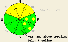
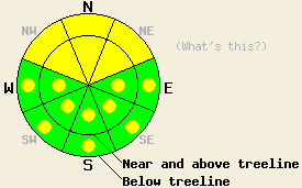
February 29, 2012 at 8:00 Near and above treeline HIGH avalanche danger will develop on NW-N-NE-E aspects, on slopes 35 degrees and steeper. Areas of HIGH avalanche danger may also form near and below treeline on NW-N-NE aspects steeper than 35 degrees. CONSIDERABLE danger exists on all other aspects. Dangerous natural and human-triggered avalanches are likely today due to high winds, intense snowfall, and a weak snowpack. Travel in or near avalanche terrain is not recommended. |
 |
|
Click here to see the full forecast for 2012-03-01 |
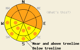
March 1, 2012 at 8:00 Near and above treeline CONSIDERABLE avalanche danger remains on NW-N-NE-E-SE aspects, on slopes 35 degrees and steeper. Areas of CONSIDERABLE avalanche danger also exist near and below treeline on NW-N-NE aspects steeper than 35 degrees with pockets of CONSIDERABLE danger on the below treeline E and SE aspects. Dangerous human-triggered avalanches remain likely and natural avalanches remain possible today due to high winds, new snowfall, and a weak snowpack. |
 |
|
Click here to see the full forecast for 2012-03-02 |
March 2, 2012 at 8:00 CONSIDERABLE avalanche danger remains on NW-N-NE-E aspects on slopes 35 degrees and steeper at all elevations with pockets of CONSIDERABLE danger on the below treeline E and SE aspects. MODERATE avalanche danger exists on the S-SW-W aspects. Dangerous human-triggered avalanches remain likely today due to complex wind loading, recent snow, and a weak snowpack. |
 |
|
Click here to see the full forecast for 2012-03-03 |
March 3, 2012 at 7:53 Avalanche danger is MODERATE both above and below treeline on NW-N-NE aspects on slopes 35 degrees and steeper due to ongoing deep slab instability. MODERATE avalanche danger is expected today both above and below treeline on E-SE-S-SW-W aspects on slopes 35 degrees and steeper due to wet snow instability forming in response to daytime warming. While natural avalanche activity has become unlikely, large destructive human triggered avalanches remain possible today. |
 |
|
Click here to see the full forecast for 2012-03-04 |
March 4, 2012 at 7:52 Avalanche danger is MODERATE both above and below treeline on NW-N-NE aspects on slopes 35 degrees and steeper due to ongoing deep slab instability. MODERATE avalanche danger is expected today both above and below treeline on E-SE-S-SW-W aspects on slopes 35 degrees and steeper due to wet snow instability forming in response to daytime warming. Large destructive human triggered avalanches are possible today. |
 |
|
Click here to see the full forecast for 2012-03-05 |
March 5, 2012 at 7:33
Avalanche danger is LOW with pockets of MODERATE danger both above and below treeline on NW-N-NE aspects on slopes 35 degrees and steeper due to ongoing deep slab instability. Avalanche danger is LOW with pockets of MODERATE danger forming today both above and below treeline on E-SE-S-SW-W aspects on slopes 37 degrees and steeper due to wet snow instability. Large destructive human triggered avalanches remain possible today in isolated areas.
|
 |
|
Click here to see the full forecast for 2012-03-06 |
March 6, 2012 at 8:00 MODERATE avalanche danger exists on NW-N-NE-E aspects on slopes 35 degrees and steeper both above and below treeline due to ongoing deep slab instability and new wind loading. Pockets of MODERATE danger may also form on wind-loaded SE aspects 35 degrees and steeper today. Large destructive human triggered avalanches remain possible today. |
 |
|
Click here to see the full forecast for 2012-03-07 |
March 7, 2012 at 8:00 Pockets of MODERATE avalanche danger exist on NW-N-NE-E-SE aspects on slopes 35 degrees and steeper both above and below treeline due to ongoing deep slab instability and some sun-exposure. Even though they seem to be growing less likely, large destructive human-triggered avalanches remain possible today in some areas. |
 |
|
Click here to see the full forecast for 2012-03-08 |
March 8, 2012 at 8:00 Pockets of MODERATE avalanche danger exist on all aspects on slopes 35 degrees and steeper both above and below treeline due to ongoing deep slab instability and daytime warming. Even though they seem to be growing more difficult to trigger, large destructive human-triggered avalanches remain possible today in some areas. |
 |
|
Click here to see the full forecast for 2012-03-09 |
March 9, 2012 at 8:00 Pockets of MODERATE avalanche danger exist both above and below treeline on NW-N-NE aspects on slopes 35 degrees and steeper due to ongoing deep slab instability. The possibility of large destructive human triggered avalanches remains in these areas. For all other areas, avalanche danger is LOW. |
 |
|
Click here to see the full forecast for 2012-03-10 |
March 10, 2012 at 7:56 Pockets of MODERATE avalanche danger exist both above and below treeline on NW-N-NE aspects on slopes 35 degrees and steeper due to ongoing deep slab instability. The possibility of large destructive human triggered avalanches remains in these areas. For all other areas, avalanche danger is LOW. |
 |
|
Click here to see the full forecast for 2012-03-11 |
March 11, 2012 at 6:44 Pockets of MODERATE avalanche danger exist both above and below treeline on NW-N-NE aspects on slopes 35 degrees and steeper due to ongoing deep slab instability. The possibility of large destructive human triggered avalanches remains in these areas. For all other areas, avalanche danger is LOW. |
 |
|
Click here to see the full forecast for 2012-03-12 |
March 12, 2012 at 7:00 Pockets of MODERATE avalanche danger exist on NW-N-NE aspects on slopes 35 degrees and steeper in both above and below treeline terrain due to ongoing deep slab instability. The possibility of large destructive human triggered avalanches remains in these areas. For all other areas, avalanche danger is LOW. |
 |
|
Click here to see the full forecast for 2012-03-13 |
March 13, 2012 at 7:00 MODERATE avalanche danger will become more widespread on NW-N-NE aspects on slopes 35 degrees and steeper in both above and below treeline terrain due to ongoing deep slab instability, new snow, and wind loading. The possibility of large destructive human triggered avalanches remains in these areas. Pockets of MODERATE danger should also form on wind-loaded and cross-loaded E and SE aspects. Some natural avalanche activity may become possible tonight due to more intense snowfall and continued wind loading. |
 |
|
Click here to see the full forecast for 2012-03-14 |
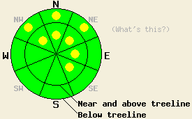
March 14, 2012 at 7:00 CONSIDERABLE avalanche danger exists at all elevations on NW-N-NE-E aspects on slopes 35 degrees and steeper due to ongoing deep slab instability, new snow, wind loading, and rain on snow. Large destructive human triggered avalanches are likely in these areas. Pockets of CONSIDERABLE danger may also form on all other aspects aspects below 8000 ft due to rain on snow. South of Hwy 50 and east of Lake Tahoe where less snow has fallen less avalanche danger exists. |
 |
|
Click here to see the full forecast for 2012-03-14 |
March 14, 2012 at 7:49 CONSIDERABLE avalanche danger exists at all elevations on NW-N-NE-E aspects on slopes 35 degrees and steeper due to ongoing deep slab instability, new snow, wind loading, and rain on snow. Large destructive human triggered avalanches are likely in these areas. Pockets of CONSIDERABLE danger may also form on all other aspects aspects below 8000 ft due to rain on snow. South of Hwy 50 and east of Lake Tahoe where less snow has fallen less avalanche danger exists. |
 |
|
Click here to see the full forecast for 2012-03-15 |
March 15, 2012 at 7:02 Both above and below treeline, avalanche danger is MODERATE with pockets of CONSIDERABLE danger on NW-N-NE aspects on slopes 35 degrees and steeper. For all other areas, avalanche danger is MODERATE. A trend of increasing avalanche danger is expected tonight and tomorrow. |
 |
|
Click here to see the full forecast for 2012-03-16 |
March 16, 2012 at 7:00 Both above and below treeline, avalanche danger is CONSIDERABLE on NW-N-NE-E aspects on slopes 35 degrees and steeper. For all other areas, avalanche danger is MODERATE. HIGH avalanche danger is expected tonight and tomorrow morning. |
 |
|
Click here to see the full forecast for 2012-03-17 |
March 17, 2012 at 6:47 Both above and below treeline, avalanche danger is CONSIDERABLE on NW-N-NE-E-SE aspects on slopes 35 degrees and steeper. For all other areas, avalanche danger is MODERATE with pockets of CONSIDERABLE danger on slopes 35 degrees and steeper. Due to the combination of several feet of new snow and persistent deep slab instability, large destructive avalanches are possible today. |
 |
|
Click here to see the full forecast for 2012-03-18 |
March 18, 2012 at 7:00 Both above and below treeline, MODERATE avalanche danger remains on NW-N-NE-E-SE aspects on slopes 35 degrees and steeper. For all other areas, avalanche danger is LOW with pockets of MODERATE danger on slopes 35 degrees and steeper. Even though avalanches may be more difficult to trigger today, huge, dangerous deep slab avalanches with serious consequences remain possible today. |
 |
|
Click here to see the full forecast for 2012-03-19 |
March 19, 2012 at 7:00 Both above and below treeline, MODERATE avalanche danger remains on NW-N-NE aspects on slopes 35 degrees and steeper. On the E and SE aspects pockets of MODERATE danger exist in near and above treeline terrain on slopes 35 degrees and steeper. Even though avalanches may be more difficult to trigger today, huge, dangerous deep slab avalanches with serious consequences remain possible. |
 |
|
Click here to see the full forecast for 2012-03-20 |
March 20, 2012 at 7:00 Both above and below treeline, MODERATE avalanche danger remains on NW-N-NE aspects on slopes 35 degrees and steeper. Even though avalanches have become more difficult to trigger today, huge, dangerous deep slab avalanches with serious consequences remain possible on these aspects. On all other aspects pockets of MODERATE danger exist on slopes 35 degrees and steeper. |
 |
|
Click here to see the full forecast for 2012-03-21 |
March 21, 2012 at 6:57 Areas of MODERATE avalanche danger exist on all aspects and at all elevations on slopes 35 degrees and steeper due to a combination of warming instability and ongoing persistent deep slab instability. Large destructive human triggered deep slab avalanches remain possible in isolated areas. Widespread surface wet snow instability is expected again today. |
 |
|
Click here to see the full forecast for 2012-03-22 |
March 22, 2012 at 6:35 Very isolated pockets of MODERATE avalanche danger exist both above and below treeline on NW-N-NE aspects on slopes 35 degrees and steeper due to ongoing persistent deep slab instability. Large destructive human triggered deep slab avalanches remain possible in these areas. For all other areas, avalanche danger is generally LOW with isolated pockets of MODERATE danger below 8,500' on slopes 37 degrees and steeper due to wet snow instability. |
 |
|
Click here to see the full forecast for 2012-03-23 |
March 23, 2012 at 6:53 Very isolated pockets of MODERATE avalanche danger exist both above and below treeline on NW-N-NE aspects on slopes 35 degrees and steeper due to ongoing persistent deep slab instability. Large destructive human triggered deep slab avalanches remain possible in these areas. For all other areas, avalanche danger is generally LOW with isolated pockets of MODERATE danger due to warming instability near and above treeline on wind loaded E-SE aspects 35 degrees and steeper. |
 |
|
Click here to see the full forecast for 2012-03-24 |
March 24, 2012 at 7:00 Pockets of MODERATE avalanche danger exist both above and below treeline on NW-N-NE aspects on slopes 35 degrees and steeper due to ongoing persistent deep slab instability and some new shallow wind slabs. Large destructive human triggered deep slab avalanches remain possible in these areas. For all other areas, avalanche danger is generally LOW with isolated pockets of MODERATE danger below 8,500' on slopes 37 degrees and steeper due to wet snow instability. |
 |
|
Click here to see the full forecast for 2012-03-25 |
March 25, 2012 at 7:00 On slopes 35 degrees and steeper, pockets of MODERATE avalanche danger exist both above and below treeline on NW-N-NE aspects and on near and above treeline E-SE aspects due to ongoing persistent deep slab instability and some new shallow wind slabs. Large destructive deep slab avalanches remain possible. For all other areas, avalanche danger is generally LOW. |
 |
|
Click here to see the full forecast for 2012-03-26 |
March 26, 2012 at 6:23 On slopes 35 degrees and steeper, pockets of MODERATE avalanche danger exist both above and below treeline on NW-N-NE aspects and on near and above treeline E-SE aspects due to ongoing persistent deep slab instability and some new shallow wind slabs. Large destructive deep slab avalanches remain possible. For all other areas, avalanche danger is generally LOW. |
 |
|
Click here to see the full forecast for 2012-03-27 |
March 27, 2012 at 6:52 Isolate pockets of MODERATE avalanche danger exist both above and below treeline on NW-N-NE aspects and near and above treeline E-SE aspects on slopes 35 degrees and steeper due to ongoing persistent deep slab instability and recently formed surface wind slabs. Large destructive deep slab avalanches remain possible in isolated areas. For all other areas, avalanche danger is generally LOW. Avalanche danger is will increase tonight for all areas with natural avalanches possible. |
 |
|
Click here to see the full forecast for 2012-03-28 |
March 28, 2012 at 6:52 Near and above treeline avalanche danger is CONSIDERABLE on NW-N-NE-E-SE aspects on slopes 35 degrees and steeper due to newly formed storm slabs, wind slabs, and ongoing persistent deep slab instability. Large destructive deep slab avalanches remain possible both above and below treeline on NW-N-NE aspects. For all other areas, avalanche danger is MODERATE on slopes 35 degrees and steeper. |
 |
|
Click here to see the full forecast for 2012-03-29 |
March 29, 2012 at 6:55 Avalanche danger is MODERATE for all elevations and aspects on slopes 35 degrees and steeper due to warming instability. Ongoing and new concerns exist for large destructive deep slab avalanches on NW-N-NE aspects both above and below treeline on slopes 35 degrees and steeper. |
 |
|
Click here to see the full forecast for 2012-03-30 |
March 30, 2012 at 6:59 MODERATE avalanche danger exists on all aspects at all elevations on slopes 35 degrees and steeper due to a combination of warming instability, recent wind slabs, and ongoing deep slab avalanche concerns. |
 |
|
Click here to see the full forecast for 2012-03-31 |
March 31, 2012 at 6:59 This morning MODERATE avalanche danger exists on all aspects at all elevations on slopes 35 degrees and steeper. By later this afternoon and this evening, CONSIDERABLE avalanche danger should develop at all elevations on the N-NE-E aspects with pockets CONSIDERABLE danger on the NW and SE aspects. Natural avalanches will become possible and human triggered avalanches will become likely in these areas due to strong wind loading, intense snowfall, and ongoing deep slab avalanche concerns. |
 |
|
Click here to see the full forecast for 2012-04-01 |
April 1, 2012 at 6:59 Pockets of CONSIDERABLE avalanche danger exist at all elevations on the N-NE-E-SE aspects on slopes 35 degrees and steeper due to new wind slabs and ongoing deep slab avalanche concerns. MODERATE avalanche danger exists on all other aspects at all elevations. |
 |
|
Click here to see the full forecast for 2012-04-02 |
April 2, 2012 at 7:00 Both above and below treeline, avalanche danger is MODERATE on SE-S-SW-W aspects on slopes 35 degrees and steeper. Additional pockets of MODERATE danger exist on NW-N-NE-E aspects on slopes 35 degrees and steeper. Ongoing concerns exist for human triggered avalanches due to warming instability, lingering storm snow instability, and persistent deep slab instability. |
 |
|
Click here to see the full forecast for 2012-04-03 |
April 3, 2012 at 6:42 Both above and below treeline, avalanche danger is LOW with pockets of MODERATE danger on all aspects on slopes 35 degrees and steeper due to warming instability and persistent deep slab instability. |
 |
|
Click here to see the full forecast for 2012-04-04 |
April 4, 2012 at 6:23 Near and above treeline, avalanche danger is LOW with pockets of MODERATE danger in the most heavily wind loaded areas on N-NE-E aspects on slopes 35 degrees and steeper. For all other areas, avalanche danger is LOW. |
 |
|
Click here to see the full forecast for 2012-04-05 |
April 5, 2012 at 6:59 Isolated pockets of MODERATE avalanche danger may still remain in the most heavily wind loaded areas on N-NE-E aspects on slopes 35 degrees and steeper in near and above treeline terrain. For all other areas, avalanche danger is LOW. |
 |
|
Click here to see the full forecast for 2012-04-06 |
April 6, 2012 at 6:59 Very isolated pockets of MODERATE avalanche danger may still remain in the most heavily wind loaded areas on N-NE-E aspects on slopes 35 degrees and steeper in near and above treeline terrain. Isolated pockets of MODERATE danger may also form near and below treeline today on SE-S-SW aspects on slopes steeper than 35 degrees with significant sun-exposure. For all other areas, avalanche danger is LOW. |
 |
|
Click here to see the full forecast for 2012-04-07 |
April 7, 2012 at 6:52 On slopes steeper than 35 degrees, MODERATE avalanche danger may form today on SE-S-SW aspects with pockets of MODERATE danger on the E and W aspects due to daytime warming. For all other areas, avalanche danger is LOW. |
 |
|
Click here to see the full forecast for 2012-04-08 |
April 8, 2012 at 6:48 Early this morning, avalanche danger is LOW for all elevations and aspects. MODERATE avalanche danger will develop in response to daytime warming on E-SE-S-SW-W aspects at all elevations on slopes 35 degrees and steeper. |
 |
|
Click here to see the full forecast for 2012-04-09 |
April 9, 2012 at 6:53 Early this morning, avalanche danger is LOW for all elevations and aspects. MODERATE avalanche danger will develop in response to daytime warming on E-SE-S-SW-W aspects at all elevations on slopes 35 degrees and steeper. |
 |
|
Click here to see the full forecast for 2012-04-10 |
April 10, 2012 at 6:41 Avalanche danger is LOW for all elevations and aspects. Normal caution is advised. |
 |
|
Click here to see the full forecast for 2012-04-11 |
April 11, 2012 at 7:00 This morning the avalanche danger remains LOW on all aspects and at all elevations. Near and above treeline some pockets of MODERATE avalanche danger may form this afternoon on N-NE-E aspects on slopes steeper than 35 degrees due to new snow and wind loading. The avalanche danger will continue to increase over the next few days as more wind and snow impact the region. |
 |
|
Click here to see the full forecast for 2012-04-12 |
April 12, 2012 at 6:59 On slopes steeper than 35 degrees near and above treeline, MODERATE avalanche danger will exist on N-NE-E aspects with pockets of MODERATE danger on the NW and SE aspects due to new snow and wind loading. Pockets of MODERATE danger may also form on below treeline NW-N-NE-E-SE aspects on slopes steeper than 35 degrees. Human triggered avalanches will be possible today. The avalanche danger will increase tonight and tomorrow morning as larger natural avalanche activity becomes possible. |
 |
|
Click here to see the full forecast for 2012-04-13 |
April 13, 2012 at 6:59 On slopes steeper than 35 degrees near and above treeline, CONSIDERABLE avalanche danger will exist on N-NE-E aspects with pockets of CONSIDERABLE danger on the NW and SE aspects due to new snow and wind loading. Pockets of CONSIDERABLE danger may also exist on below treeline NW-N-NE-E-SE aspects on slopes steeper than 35 degrees. Human triggered avalanches are likely today, and natural avalanche are possible. |
 |
|
Click here to see the full forecast for 2012-04-14 |
April 14, 2012 at 6:40 Both above and below treeline, avalanche danger is LOW with pockets of MODERATE danger in wind loaded areas on all aspects on slopes 35 degrees and steeper. Areas of unstable snow will exist within surrounding areas of seemingly stable snow. |
 |
|
Click here to see the full forecast for 2012-04-15 |
April 15, 2012 at 6:48 Both above and below treeline widespread MODERATE avalanche danger will form on E-SE-S-SW-W aspects on slopes 35 degrees and steeper in response to daytime warming. On NW-N-NE aspects, avalanche danger is LOW with pockets of MODERATE danger in wind loaded areas both above and below treeline on slopes 35 degrees and steeper. Areas of unstable snow will exist within surrounding areas of seemingly stable snow. |
 |
|
Click here to see the full forecast for 2012-04-16 |
April 16, 2012 at 6:33 Both above and below treeline widespread MODERATE avalanche danger will form quickly today on all aspects on slopes 35 degrees and steeper in response to daytime warming. |
 |
|
Click here to see the full forecast for 2012-04-17 |
April 17, 2012 at 7:00 Both above and below treeline widespread MODERATE avalanche danger will quickly form today on all aspects on slopes 35 degrees and steeper in response to daytime warming. |
 |
|
Click here to see the full forecast for 2012-04-18 |
April 18, 2012 at 7:01 Widespread MODERATE avalanche danger will form today on all aspects on slopes 35 degrees and steeper at all elevations in response to daytime warming. |
 |
|
Click here to see the full forecast for 2012-04-19 |
April 19, 2012 at 6:41 MODERATE avalanche danger will form quickly today on all aspects on slopes 35 degrees and steeper at all elevations in response to daytime warming. |
 |
|
Click here to see the full forecast for 2012-04-20 |
April 20, 2012 at 6:27 Widespread MODERATE avalanche danger will form quickly today on all aspects at all elevations on slopes 35 degrees and steeper in response to daytime warming. The vast majority of instability that occurs today is likely to be human triggered, but an isolated natural avalanche event is not out of the question. |
 |
|
Click here to see the full forecast for 2012-04-21 |
April 21, 2012 at 6:31 Widespread MODERATE avalanche danger will form quickly today on all aspects at all elevations on slopes 35 degrees and steeper in response to daytime warming. Pockets of CONSIDERABLE danger may form this afternoon on slopes 37 degrees and steeper. The vast majority of instability that occurs today is likely to be human triggered, but an isolated natural avalanche event is not out of the question. |
 |
|
Click here to see the full forecast for 2012-04-22 |
April 22, 2012 at 6:30 Widespread MODERATE avalanche danger will form quickly today on all aspects at all elevations on slopes 35 degrees and steeper in response to daytime warming. Pockets of CONSIDERABLE danger may form this afternoon on slopes 37 degrees and steeper. The vast majority of instability that occurs today is likely to be human triggered, but an isolated natural avalanche event is possible. |
 |
|
Click here to see the full forecast for 2012-04-23 |
April 23, 2012 at 6:37 Widespread MODERATE avalanche danger will form quickly today on all aspects at all elevations on slopes 35 degrees and steeper in response to daytime warming. Pockets of CONSIDERABLE danger may form this afternoon on slopes 37 degrees and steeper. The majority of instability that occurs today is likely to be human triggered, but natural avalanches are possible in isolated areas. |
 |
|
Click here to see the full forecast for 2012-04-24 |
April 24, 2012 at 6:45 Widespread MODERATE avalanche danger will form quickly today on all aspects at all elevations on slopes 30 degrees and steeper in response to daytime warming. Pockets of CONSIDERABLE danger may form this afternoon on slopes 35 degrees and steeper. The majority of instability that occurs today is likely to be human triggered, but natural avalanches are possible in isolated areas. |
 |
|
Click here to see the full forecast for 2012-04-25 |
April 25, 2012 at 7:00 Widespread MODERATE avalanche danger will form on all aspects at all elevations on slopes 30 degrees and steeper due to daytime warming and rain on the snowpack today. If more rain impacts the area than forecasted, the danger of wet avalanches will increase. |
 |
|
Click here to see the full forecast for 2012-04-26 |
April 26, 2012 at 6:54 Widespread MODERATE avalanche danger exists on all aspects at all elevations on slopes 32 degrees and steeper due to wet snow instability formed by rain on snow. The vast majority of avalanche activity today is expected to be human triggered, but an isolated natural avalanche is not impossible. |
 |
|
Click here to see the full forecast for 2012-04-27 |
April 27, 2012 at 6:28 This morning, MODERATE avalanche danger exists near and above treeline in recently wind loaded areas on NW-N-NE-E aspects on slopes 35 degrees and steeper. A transition will occur during the late morning and afternoon hours to warming and wet snow instability. Pockets of CONSIDERABLE avalanche danger are expected to form at all elevations on all aspects on slopes 35 degrees and steeper by this afternoon. |
 |
|
Click here to see the full forecast for 2012-04-28 |
April 28, 2012 at 6:20 Early this morning, avalanche danger is LOW for all elevations and aspects. Widespread MODERATE avalanche danger will form today at all elevations and on all aspects in response to daytime warming. The vast majority of any avalanche activity that occurs today is expected to be human triggered. An isolated natural avalanche occurrence is unlikely, but not outside the realm of possibility during the late afternoon hours. |
 |
|
Click here to see the full forecast for 2012-04-29 |
April 29, 2012 at 7:00 We have stopped issuing daily avalanche advisories until the fall of 2012. The avalanche danger can and will change quickly this spring. Continue to monitor changing conditions and use caution when traveling in the backcountry. For general spring avalanche information read the full spring avalanche statement. |
|
|
Click here to see the full forecast for 2012-10-21 |
October 21, 2012 at 11:21 Fall Avalanche Statement Daily avalanche advisories are planned to resume in mid November or later as conditions dictate. Occasional intermittent early season updates to this page may occur earlier if conditions warrant and resources are available. |
|
|
Click here to see the full forecast for 2012-10-24 |
October 24, 2012 at 16:30 Early season conditions update #1 We are just beginning to collect field data on current snowpack and avalanche conditions. At this time we do not have sufficient information to issue avalanche advisories, but we are working to share the information that we do know. Daily avalanche advisories are planned to resume in November as conditions dictate. Intermittent early season updates to this page will occur earlier as conditions warrant. |
|
|
Click here to see the full forecast for 2012-10-27 |
October 27, 2012 at 21:23 Early season conditions update #2 We do not have enough information to issue regular avalanche advisories. We have started to collect data and will be sharing all of the information we gather on our observations page and in intermittent updates to this page. We plan to resume daily avalanche advisories in November as conditions dictate. |
|
|
Click here to see the full forecast for 2012-11-01 |
November 1, 2012 at 17:01 Early season conditions update #3 We do not have enough information to issue regular avalanche advisories. We have started to collect data and will be sharing all of the information we gather on our observations page and in intermittent updates to this page. We plan to resume daily avalanche advisories in November as conditions dictate. |
|
|
Click here to see the full forecast for 2012-11-08 |
November 8, 2012 at 9:04 Early season conditions update #4 We do not have enough information to issue regular avalanche advisories. We have started to collect data and will be sharing all of the information we gather on our observations page and in intermittent updates to this page. We plan to resume daily avalanche advisories in November as conditions dictate. |
|
|
Click here to see the full forecast for 2012-11-13 |
November 13, 2012 at 17:14 Early season conditions update #5 We are returning to full staffing levels this week. We plan to resume daily avalanche advisories as storm systems affect the forecast area at the end of this week. In the mean time we will continue sharing all of the information we gather on our observations page. |
|
|
Click here to see the full forecast for 2012-11-16 |
November 16, 2012 at 7:45 Rain on snow is expected to create areas of MODERATE avalanche danger both above and below treeline on NW-N-NE aspects on slopes 35 degrees and steeper. For all other areas, avalanche danger remains LOW. |
 |
|
Click here to see the full forecast for 2012-11-17 |
November 17, 2012 at 7:04 Rain on snow, strong winds, and new snowfall will create areas of MODERATE avalanche danger on both above and below treeline NW-N-NE-E aspects on slopes 35 degrees and steeper. For all other areas, avalanche danger remains LOW. |
 |
|
Click here to see the full forecast for 2012-11-18 |
November 18, 2012 at 7:54 Strong winds and new snowfall have created MODERATE avalanche danger on near and above treeline NW-N-NE-E aspects on slopes steeper than 35 degrees above 7500 ft. Human triggered avalanches are possible in these areas. For all other areas, avalanche danger remains LOW. |
 |
|
Click here to see the full forecast for 2012-11-19 |
November 19, 2012 at 7:40 Near and above treeline, lingering pockets of MODERATE avalanche danger exist on NW-N-NE aspects on slope 35 degrees and steeper. For all other areas, avalanche danger is LOW. |
 |
|
Click here to see the full forecast for 2012-11-20 |
November 20, 2012 at 7:45 Near and above treeline, very isolated pockets of MODERATE avalanche danger exist on NW-N-NE aspects on slope 35 degrees and steeper. For all other areas, avalanche danger is LOW. |
 |


This website is owned and maintained by the non-profit arm of the Sierra Avalanche Center. Some of the content is updated by the USDA avalanche forecasters including the forecasts and some observational data. The USDA is not responsible for any advertising, fund-raising events/information, or sponsorship information, or other content not related to the forecasts and the data pertaining to the forecasts.