In partnership with: 
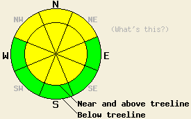
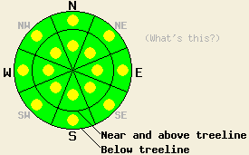
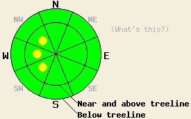
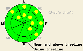
Use this page to view archived advisories. The table below shows the overall danger rating and the bottom line for the 20 most recent advisories. Click on the time and date link above each danger rating icon to view the full advisory for that day. Use the date chooser or the pager at the bottom to scroll through the older advisories.
|
Date the forecast was published: |
Bottom Line | |
|---|---|---|
|
Click here to see the full forecast for 2012-11-21 |
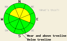
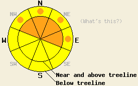
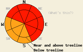
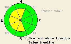
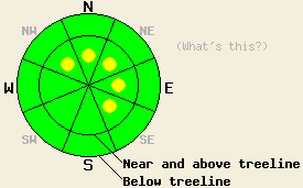
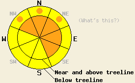
November 21, 2012 at 7:38 Near and above treeline, pockets of MODERATE avalanche danger exist on NW-N-NE aspects on slopes 35 degrees and steeper due to recently formed wind slabs and ongoing persistent slabs. For all other areas, avalanche danger is LOW. The next update to this advisory will occur on Friday, November 23rd. |
 |
|
Click here to see the full forecast for 2012-11-23 |
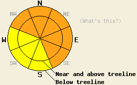
November 23, 2012 at 7:59 Near and above treeline, isolated pockets of MODERATE avalanche danger may still exist on NW-N-NE aspects on slopes 35 degrees and steeper due to ongoing persistent slabs. For all other areas, avalanche danger is LOW. LOW danger does not mean no danger. |
 |
|
Click here to see the full forecast for 2012-11-24 |
November 24, 2012 at 7:17 For most of the area the avalanche danger remains LOW. A few small isolated pockets of MODERATE avalanche danger may still exist on near and above treeline NW-N-NE aspects steeper than 35 degrees. LOW danger does not mean no danger. |
 |
|
Click here to see the full forecast for 2012-11-25 |
November 25, 2012 at 7:52 Today the avalanche danger is LOW. LOW danger does not mean no danger. Some unstable snow may still linger on isolated terrain features especially on high elevation NW-N-NE aspects in complex or extreme terrain. Use normal caution when traveling in the backcountry. |
 |
|
Click here to see the full forecast for 2012-11-26 |
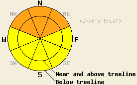
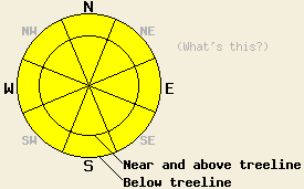
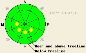
November 26, 2012 at 7:24 Avalanche danger is LOW for all elevations and aspects. Very isolated areas of unstable snow may exist above 9,000' on NW-N-NE aspects in complex or extreme terrain. |
 |
|
Click here to see the full forecast for 2012-11-27 |
November 27, 2012 at 7:45 Avalanche danger is LOW for all elevations and aspects. Very isolated areas of unstable snow may exist above 9,000' on NW-N-NE aspects in complex or extreme terrain. |
 |
|
Click here to see the full forecast for 2012-11-28 |
November 28, 2012 at 7:54 Today the avalanche danger will rise to MODERATE on near and above treeline NW-N-NE-E aspects steeper than 35 degrees due to new snow and wind impacting the forecast area. In other areas the avalanche danger should remain LOW. A few very isolated areas of unstable snow may exist above 9,000' on NW-N-NE aspects in complex or extreme terrain in areas of LOW danger. |
 |
|
Click here to see the full forecast for 2012-11-29 |
November 29, 2012 at 8:00 MODERATE avalanche danger exists on near and above treeline NW-N-NE-E aspects steeper than 35 degrees due to new snow, strong winds, and some areas of persistent weak layers. In other areas the avalanche danger should remain LOW. Expect the avalanche danger to increase tonight and continue to rise as a large storm impacts the region over the next few days. |
 |
|
Click here to see the full forecast for 2012-11-30 |
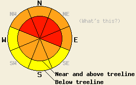
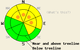
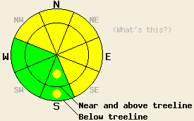
November 30, 2012 at 7:53 Near and above treeline on NW-N-NE-E aspects steeper than 35 degrees the avalanche danger is HIGH due to intense snowfall, gale force winds, and persistent weak layers in the snowpack. Below treeline the danger on these aspects is CONSIDERABLE. Large human triggered and natural avalanche are likely today. Travel in or below avalanche terrain is not recommended. |
 |
|
Click here to see the full forecast for 2012-12-01 |
December 1, 2012 at 8:02 Both above and below treeline, areas of CONSIDERABLE avalanche danger will exist today due to new snow loading and wind loading. Danger will be greatest above 8,000' on NW-N-NE-E aspects steeper than 35 degrees. Widespread HIGH avalanche danger is expected to occur tonight into Sunday due to rain on new snow up to 10,000'. |
 |
|
Click here to see the full forecast for 2012-12-02 |
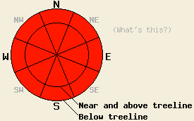
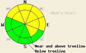
December 2, 2012 at 7:57 Both above and below treeline, avalanche danger is HIGH on all aspects on slopes 32 degrees and steeper due to rain on new snow up to 10,000'.Travel in or below avalanche terrain is not recommended. |
 |
|
Click here to see the full forecast for 2012-12-03 |
December 3, 2012 at 7:42 Near and above treeline, avalanche danger is MODERATE on NW-N-NE-E aspects on slopes 35 degrees and steeper due to lingering wind slabs and storm slabs. For all other areas, avalanche danger is LOW. |
 |
|
Click here to see the full forecast for 2012-12-04 |
December 4, 2012 at 8:00 Near and above treeline, avalanche danger remains MODERATE on NW-N-NE-E aspects on slopes steeper than 35 degrees due to lingering wind slabs and rain on snow today and tonight. For all other areas, avalanche danger is LOW with pockets of MODERATE danger on snow-covered slopes steeper than 35 degrees that receive rain today. Expect the avalanche danger to increase as more rain, snow, and wind impact the forecast area tonight and tomorrow. |
 |
|
Click here to see the full forecast for 2012-12-05 |
December 5, 2012 at 8:00 CONSIDERABLE avalanche danger exists on snow-covered slopes steeper than 35 degrees due to a mix of rain on snow, new snow, and wind. Human triggered avalanches are likely today and natural avalanches will be possible. |
 |
|
Click here to see the full forecast for 2012-12-06 |
December 6, 2012 at 8:04 Above 9000 ft in near and above treeline terrain, MODERATE avalanche danger may linger on pockets of NW-N-NE-E aspects on slopes steeper than 35 degrees due to wind slabs. For all other areas, avalanche danger is LOW. |
 |
|
Click here to see the full forecast for 2012-12-07 |
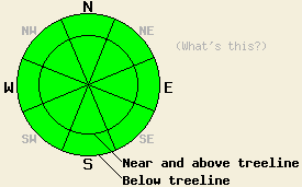
December 7, 2012 at 7:53 Avalanche danger is LOW for all elevations and aspects. Normal caution is advised. Long, unarrested sliding falls down icy slopes leading to impact with trees or rocks is likely the greatest hazard in the backcountry today. |
 |
|
Click here to see the full forecast for 2012-12-08 |
December 8, 2012 at 7:43 Avalanche danger is LOW for all elevations and aspects. Normal caution is advised. Long, unarrested sliding falls down icy slopes leading to impact with trees or rocks is likely the greatest hazard in the backcountry today. |
 |
|
Click here to see the full forecast for 2012-12-09 |
December 9, 2012 at 7:46 Avalanche danger remains LOW for all elevations and aspects. Normal caution is advised. A long, unarrested, sliding fall down icy slopes leading to impact with trees or rocks is likely the greatest hazard in the backcountry today. |
 |
|
Click here to see the full forecast for 2012-12-10 |
December 10, 2012 at 8:01 The avalanche danger remains LOW for all elevations and aspects. Continue to use normal caution when traveling in the backcountry. Icy slopes pose the greatest hazard by making long sliding falls that are difficult to control or arrest a real possibility today. |
 |
|
Click here to see the full forecast for 2012-12-11 |
December 11, 2012 at 7:59 The avalanche danger remains LOW for all elevations and aspects. Continue to use normal caution when traveling in the backcountry. Icy slopes pose the greatest hazard by making long sliding falls that are difficult to control or arrest a real possibility today. |
 |
|
Click here to see the full forecast for 2012-12-12 |
December 12, 2012 at 8:00 Near and above treeline the avalanche danger will increase to MODERATE on NW-N-NE-E aspects steeper than 35 degrees due to new snow and wind. Pockets of MODERATE danger may form on those aspects in wind loaded below treeline terrain as well. Human triggered avalanches will be possible today. Use caution and evaluate snow covered slopes carefully when traveling in the backcountry. |
 |
|
Click here to see the full forecast for 2012-12-13 |
December 13, 2012 at 7:51 Near and above treeline, avalanche danger remains MODERATE on NW-N-NE-E aspects steeper than 35 degrees due to lingering wind slabs. For all other areas, avalanche danger is LOW. |
 |
|
Click here to see the full forecast for 2012-12-14 |
December 14, 2012 at 7:45 Avalanche danger is LOW for all elevations and aspects. Normal caution is advised. Isolated areas of instability may exist, especially in extreme terrain. |
 |
|
Click here to see the full forecast for 2012-12-15 |
December 15, 2012 at 8:01 Near and above treeline, avalanche danger is MODERATE due to wind slabs on NW-N-NE-E aspects on slopes 35 degrees and steeper. Below treeline, avalanche danger is LOW with pockets of MODERATE danger on wind loaded NW-N-NE-E aspects on slopes 35 degrees and steeper. |
 |
|
Click here to see the full forecast for 2012-12-16 |
December 16, 2012 at 7:32 Near and above treeline, the avalanche danger remains MODERATE on NW-N-NE-E aspects on slopes 35 degrees and steeper due to continued wind and snow. Below treeline, the avalanche danger is LOW with pockets of MODERATE danger on wind loaded NW-N-NE-E aspects on slopes 35 degrees and steeper. |
 |
|
Click here to see the full forecast for 2012-12-17 |
December 17, 2012 at 8:00 UPDATED AT 9:00am Near and above treeline the avalanche danger is CONSIDERABLE on the NW-N-NE-E aspects on slopes 35 degrees and steeper due to continued wind and new snow. Below treeline, pockets of CONSIDERABLE avalanche danger exist on wind loaded NW-N-NE-E aspects steeper than 35 degrees. Human triggered avalanches will be likely today and natural avalanches will be possible. |
 |
|
Click here to see the full forecast for 2012-12-18 |
December 18, 2012 at 7:53 Near and above treeline pockets of CONSIDERABLE avalanche danger remain on the NW-N-NE-E aspects on slopes steeper than 35 degrees due to fragile wind slabs resting on buried weak layers. Below treeline, the avalanche danger is MODERATE on wind loaded NW-N-NE-E aspects steeper than 35 degrees. Human triggered avalanches will be possible in many areas today and likely in some of the most heavily wind loaded areas. |
 |
|
Click here to see the full forecast for 2012-12-19 |
December 19, 2012 at 8:00 Both above and below treeline, avalanche danger is MODERATE on NW-N-NE-E aspects on slopes 35 degrees and steeper due to persistent slabs and lingering wind slabs. Large and destructive human triggered avalanches are possible in these areas. For other areas, avalanche danger is LOW. |
 |
|
Click here to see the full forecast for 2012-12-20 |
December 20, 2012 at 7:39 Both above and below treeline, avalanche danger is MODERATE on NW-N-NE-E aspects on slopes 35 degrees and steeper due to wind slabs and persistent slabs. Large and destructive human triggered avalanches are possible in these areas. For other areas, avalanche danger is LOW. |
 |
|
Click here to see the full forecast for 2012-12-21 |
December 21, 2012 at 7:24 Both above and below treeline, avalanche danger will rise to CONSIDERABLE today on NW-N-NE aspects on slopes 35 degrees and steeper due to wind slabs and persistent slabs. For other areas, avalanche danger is MODERATE on slopes 35 degrees and steeper. Avalanche danger is expected to further increase to HIGH danger tonight as continued snowfall occurs. |
 |
|
Click here to see the full forecast for 2012-12-22 |
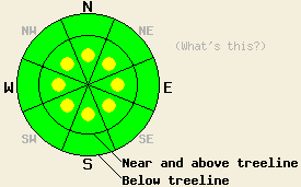
December 22, 2012 at 8:00 The avalanche danger is HIGH at all elevations on the NW-N-NE-E-SE aspects on slopes steeper than 33 degrees due to new snow loading an already weak snowpack. Large, destructive human triggered and natural avalanches will be widespread today. Very Dangerous avalanche conditions exist, and travel in or below avalanche terrain is not recommenced. |
 |
|
Click here to see the full forecast for 2012-12-23 |
December 23, 2012 at 8:00 The avalanche danger is HIGH at all elevations on the NW-N-NE-E-SE aspects on slopes steeper than 33 degrees due to wind slabs and heavy snow loads accumulating on an already weak snowpack. Large, destructive human triggered and natural avalanches will be widespread today. Very Dangerous avalanche conditions exist, and travel in or below avalanche terrain is not recommenced. |
 |
|
Click here to see the full forecast for 2012-12-24 |
December 24, 2012 at 8:01 This forecast is vaild for 48 hours. We will update it again on Dec. 26th. Below and above treeline CONSIDERABLE the avalanche danger exists on all aspects on slopes steeper than 33 degrees due to wind slabs and heavy snow loads sitting on an a weak snowpack. Large, destructive human triggered avalanches will remain likely. Natural avalanches will remain possible. Dangerous avalanche conditions exist. Careful snowpack evaluation, cautious route finding, and conservative decision making are essential. |
 |
|
Click here to see the full forecast for 2012-12-26 |
December 26, 2012 at 7:59 Avalanche danger is CONSIDERABLE both above and below treeline on NW-N-NE-E-SE aspects on slopes 32 degrees and steeper. For all other areas, avalanche danger is MODERATE. A mix of newly formed wind slabs and heavy snow loads sitting on top of already weak persistent deep slabs will keep large destructive human triggered avalanches likely today. Natural avalanches are possible. Dangerous avalanche conditions exist. Careful snowpack evaluation, cautious route finding, and conservative decision making are essential. |
 |
|
Click here to see the full forecast for 2012-12-27 |
December 27, 2012 at 7:46 Avalanche danger is MODERATE both above and below treeline on all aspects on slopes 35 degrees and steeper. A mix of recently formed wind slabs and heavy snow loads sitting on top of weak persistent deep slabs will keep large destructive human triggered avalanches possible today. Natural avalanches are unlikely. Adjust travel tactics accordingly to account for the possibility of triggering large long running avalanches from locations low on slopes and from significant distances away. |
 |
|
Click here to see the full forecast for 2012-12-28 |
December 28, 2012 at 8:00 MODERATE avalanche danger exists today both above and below treeline on all aspects on slopes 35 degrees and steeper. A mix of recently formed wind slabs and heavy snow loads sitting on top of weak persistent deep slabs will allow large destructive human triggered avalanches to remain possible. Natural avalanches are unlikely. Adjust travel tactics accordingly to account for the possibility of triggering large long running avalanches from locations low on slopes and from significant distances away. |
 |
|
Click here to see the full forecast for 2012-12-29 |
December 29, 2012 at 8:01 MODERATE avalanche danger exists today on slopes steeper than 35 degrees in both above and below treeline on NW-N-NE-E-SE aspects with pockets of MODERATE danger on the S aspects. Heavy snow loads sitting on top of weak persistent deep slabs will allow large destructive human triggered avalanches to remain possible. Even though these avalanches have become less likely, the consequences of such a slide would be very high. |
 |
|
Click here to see the full forecast for 2012-12-30 |
December 30, 2012 at 7:48 MODERATE avalanche danger exists today on slopes steeper than 35 degrees in both above and below treeline on NW-N-NE-E-SE aspects with pockets of MODERATE danger on the S aspects. Lingering wind slabs in isolated areas and heavy snow loads sitting on top of weak persistent deep slabs will allow large destructive human triggered avalanches to remain possible. Even though these avalanches have become less likely, the consequences of such a slide would be very high. |
 |
|
Click here to see the full forecast for 2012-12-31 |
December 31, 2012 at 7:52 Near and above treeline, pockets of MODERATE avalanche danger exist on all aspects on slopes 35 degrees and steeper. For all other areas, avalanche danger is LOW. Expect to find isolated areas of unstable snow in wind affected complex terrain in and around areas of chutes, cliffs, and exposed rocks. This advisory is valid for 48 hours from the time of issue. The next scheduled update will occur on January 2, 2013 by 7am. |
 |
|
Click here to see the full forecast for 2013-01-02 |
January 2, 2013 at 7:41 Avalanche danger is LOW for all elevations and aspects. Isolated areas of unstable snow may exist in wind affected complex terrain in and around areas of chutes, gullies, cliffs, and exposed rocks. Normal caution is advised. |
 |
|
Click here to see the full forecast for 2013-01-03 |
January 3, 2013 at 8:00 Avalanche danger remains LOW for all elevations and aspects. LOW danger means avalanches are unlikely not that they are impossible. Isolated areas of unstable snow may exist in complex terrain in and around areas of chutes, gullies, cliffs, and exposed rocks. Continue to use normal caution when travelling in the backcountry. |
 |
|
Click here to see the full forecast for 2013-01-04 |
January 4, 2013 at 7:37 Avalanche danger remains LOW for all elevations and aspects. During LOW danger avalanches are unlikely but not impossible. Isolated areas of unstable snow may exist in complex or extreme terrain in and around areas of chutes, gullies, cliffs, and exposed rocks. Continue to use normal caution when travelling in the backcountry. |
 |
|
Click here to see the full forecast for 2013-01-05 |
January 5, 2013 at 7:52 Avalanche danger remains LOW for all elevations and aspects. During LOW danger avalanches are unlikely but not impossible. Areas of unstable snow might exist on isolated terrain features. Continue to use normal caution when travelling in the backcountry. |
 |
|
Click here to see the full forecast for 2013-01-06 |
January 6, 2013 at 7:59 Near and above treeline, MODERATE avalanche danger will spread to all aspects on slopes 35 degrees and steeper due to unstable wind slabs. Below treeline, areas of MODERATE avalanche danger will form today on NW-N-NE aspects on slopes 30 degrees and steeper due to storm slabs deposited on top of surface hoar. |
 |
|
Click here to see the full forecast for 2013-01-07 |
January 7, 2013 at 7:58 Near and above treeline, avalanche danger is LOW with pockets of MODERATE danger on all aspects on slopes 35 degrees and steeper due to recently formed wind slabs. Below treeline, avalanche danger is LOW with pockets of MODERATE danger on all aspects on slopes 32 degrees and steeper along the Sierra Crest from roughly Emerald Bay southward. Expect a wide variance in stability from one location to another within the forecast area due to large differences in locally accumulated new snow amounts on Sunday. |
 |
|
Click here to see the full forecast for 2013-01-08 |
January 8, 2013 at 7:46 Near and above treeline, avalanche danger is LOW with pockets of MODERATE danger on SW-W-NW aspects on slopes 35 degrees and steeper due to recently formed wind slabs. Below treeline, generally LOW avalanche danger exists. Isolated areas of snowpack instability may exist below treeline near the Sierra Crest from Hwy 88 southward. |
 |
|
Click here to see the full forecast for 2013-01-09 |
January 9, 2013 at 8:00 Above and below treeline, avalanche danger is LOW with pockets of MODERATE danger on NW-N-NE-E-SE aspects on slopes 35 degrees and steeper due to newly formed wind slabs. Human triggered avalanches will be possible today. Continued strong winds over the next 24 hours combined with new snow tonight will cause the avalanche danger to increase and become more widespread. |
 |
|
Click here to see the full forecast for 2013-01-10 |
January 10, 2013 at 8:02 Near and above treeline, the avalanche danger is MODERATE on NW-N-NE-E-SE-S-SW aspects on slopes 35 degrees and steeper due to new snow and shifting winds forming new wind slabs. Below treeline pockets MODERATE danger exist on those same aspects. Human triggered avalanches will be possible today. |
 |
|
Click here to see the full forecast for 2013-01-11 |
January 11, 2013 at 7:52 Pockets of MODERATE avalanche danger exist on NW-N-NE-E-SE-S-SW aspects on slopes steeper than 35 degrees due recent snow and moderate to strong winds. Human triggered avalanches will remain possible today. |
 |
|
Click here to see the full forecast for 2013-01-12 |
January 12, 2013 at 7:50 Near and above treeline, pockets of MODERATE avalanche danger exist on E-SE-S-SW aspects on slopes 35 degrees and steeper due to recently formed wind slabs. For all other areas avalanche danger is LOW. Please keep in mind that the definition of LOW danger includes small avalanches in isolated areas or extreme terrain. |
 |
|
Click here to see the full forecast for 2013-01-13 |
January 13, 2013 at 7:47 Avalanche danger is LOW for all elevations and aspects.Normal caution is advised. Please keep in mind that the definition of LOW danger includes small avalanches in isolated areas or extreme terrain. |
 |
|
Click here to see the full forecast for 2013-01-14 |
January 14, 2013 at 7:46 Near and above treeline, avalanche danger is MODERATE on SE-S-SW-W-NW aspects on slopes 35 degrees and steeper. New wind slabs formed late yesterday afternoon and last night. For all other areas, avalanche danger is LOW. |
 |
|
Click here to see the full forecast for 2013-01-15 |
January 15, 2013 at 8:00 Near and above treeline, avalanche danger is MODERATE on S-SW-W-NW-N aspects on slopes steeper than 35 degrees due to wind slabs formed by the strong NE winds. For all other areas, avalanche danger is LOW. Even in the LOW danger areas unstable snow could still exist on isolated terrain features. |
 |
|
Click here to see the full forecast for 2013-01-16 |
January 16, 2013 at 7:59 Near and above treeline, avalanche danger is MODERATE on all aspects on slopes steeper than 35 degrees due to recently formed wind slabs resting on a variety of weak layers. Below treeline avalanche danger is LOW. Even in the LOW danger areas unstable snow could still exist on isolated terrain features. |
 |
|
Click here to see the full forecast for 2013-01-17 |
January 17, 2013 at 7:59 Near and above treeline on slopes steeper than 35 degrees, MODERATE avalanche danger exists on SE-S-SW-W-NW aspects with pockets of MODERATE danger on the E and N aspects due to recently formed wind slabs resting on a variety of weak layers and daytime warming. Below treeline avalanche danger is LOW with pockets of MODERATE danger on the SE-S-SW aspects due to daytime warming. |
 |
|
Click here to see the full forecast for 2013-01-18 |
January 18, 2013 at 7:57 On a regional scale avalanche danger is LOW for all elevations and aspects as human triggered avalanches have become unlikely. Isolated areas of unstable hard wind slabs remain possible in near and above treeline terrain. Normal caution is advised. |
 |
|
Click here to see the full forecast for 2013-01-19 |
January 19, 2013 at 7:40 On a regional scale avalanche danger is LOW for all elevations and aspects as human triggered avalanches are unlikely. Isolated areas of unstable hard wind slabs remain possible in near and above treeline terrain. Normal caution is advised. |
 |
|
Click here to see the full forecast for 2013-01-20 |
January 20, 2013 at 7:40 On a regional scale avalanche danger is LOW for all elevations and aspects as human triggered avalanches are unlikely. Isolated areas of unstable hard wind slabs remain possible in near and above treeline terrain. Normal caution is advised. |
 |
|
Click here to see the full forecast for 2013-01-21 |
January 21, 2013 at 8:00 The avalanche danger remains LOW for all elevations and aspects on a regional scale. Even though avalanche activity is unlikley, small pockets of unstable snow may still lurk on isolated terrain features. Continue to use normal caution when travelling in the backcountry. |
 |
|
Click here to see the full forecast for 2013-01-22 |
January 22, 2013 at 8:00 On a regional scale, the avalanche danger remains LOW for all elevations and aspects. Even though avalanche activity is unlikley, small pockets of unstable snow may still lurk on isolated terrain features. Continue to use normal caution when travelling in the backcountry. |
 |
|
Click here to see the full forecast for 2013-01-23 |
January 23, 2013 at 7:51 The avalanche danger remains LOW for all elevations and aspects. Continue to use normal caution when travelling in the backcountry. |
 |
|
Click here to see the full forecast for 2013-01-24 |
January 24, 2013 at 7:49 Avalanche danger remains LOW for all elevations and aspects. Normal caution is advised. |
 |
|
Click here to see the full forecast for 2013-01-25 |
January 25, 2013 at 7:50 Pockets of MODERATE avalanche danger exist below treeline on N-NE aspects on slopes 35 degrees and steeper. For all other areas, avalanche danger remains LOW. Small loose wet snow avalanches are possible today due to rain on snow. |
 |
|
Click here to see the full forecast for 2013-01-26 |
January 26, 2013 at 7:37 Pockets of MODERATE avalanche danger exist below treeline on N-NE aspects on slopes 37 degrees and steeper. For all other areas, avalanche danger remains LOW. Small loose wet snow avalanches remain possible in a variety of areas today due to recent rain on snow. |
 |
|
Click here to see the full forecast for 2013-01-27 |
January 27, 2013 at 8:00 On slopes steeper than 35 degrees, pockets of MODERATE avalanche danger exist on near and above treeline NW-N-NE-E-SE aspects due to newly formed wind slabs resting on frozen rain crusts. Small loose dry snow avalanches may be possible on some steep slopes today due new snow resting on frozen crusts. |
 |
|
Click here to see the full forecast for 2013-01-28 |
January 28, 2013 at 7:47 Even though small avalanches could occur today in isolated areas or extreme terrain due to isolated small, shallow wind slabs, the avalanche danger is LOW on all aspects and at all elevations on a regional scale. While the avalanche danger may be LOW, other hazards like long sliding falls on hard icy snow do still exist in the backcountry. |
 |
|
Click here to see the full forecast for 2013-01-29 |
January 29, 2013 at 7:53 Isolated pockets of MODERATE avalanche danger exist on slopes steeper than 35 degrees on near and above treeline SE-S-SW-W aspects due to NE winds building wind slabs on those aspects. LOW avalanche danger exists on all other aspects. Even though the avalanche danger remains isolated other hazards like long sliding falls on hard icy snow do still exist in the backcountry. |
 |
|
Click here to see the full forecast for 2013-01-30 |
January 30, 2013 at 7:45 Avalanche danger is LOW for all elevations and aspects. Normal caution is advised. In some above treeline areas, surface rain crusts are smooth, hard, and difficult to travel. Long sliding falls may be difficult to self arrest. |
 |
|
Click here to see the full forecast for 2013-01-31 |
January 31, 2013 at 7:45 Avalanche danger is LOW for all elevations and aspects. Normal caution is advised. |
 |
|
Click here to see the full forecast for 2013-02-01 |
February 1, 2013 at 7:57 Avalanche danger is LOW for all elevations and aspects. Normal caution is advised. |
 |
|
Click here to see the full forecast for 2013-02-02 |
February 2, 2013 at 8:00 The avalanche danger remains LOW for all elevations and aspects. Continue to use normal caution when travelling in the backcountry. |
 |
|
Click here to see the full forecast for 2013-02-03 |
February 3, 2013 at 7:40 The avalanche danger remains LOW for all elevations and aspects. Continue to use normal caution when travelling in the backcountry. |
 |
|
Click here to see the full forecast for 2013-02-04 |
February 4, 2013 at 7:47 The avalanche danger remains LOW for all elevations and aspects. Continue to use normal caution when travelling in the backcountry. |
 |
|
Click here to see the full forecast for 2013-02-05 |
February 5, 2013 at 7:45 Avalanche danger remains LOW for all elevations and aspects. Normal caution is advised. |
 |
|
Click here to see the full forecast for 2013-02-06 |
February 6, 2013 at 7:50 Avalanche danger remains LOW for all elevations and aspects. Normal caution is advised. |
 |
|
Click here to see the full forecast for 2013-02-07 |
February 7, 2013 at 7:52 For most of today, avalanche danger will remain LOW for all elevations and aspects. Increasing avalanche danger will occur this evening and during the overnight hours as wind slabs form near and above treeline on NW-N-NE-E-SE aspects and human triggered avalanches become possible. |
 |
|
Click here to see the full forecast for 2013-02-08 |
February 8, 2013 at 7:55 On slopes steeper than 35 degrees, isolated pockets of MODERATE avalanche danger may exist on near and above treeline aspects due new wind slabs resting on frozen crusts. Small loose dry snow avalanches may also be possible on some steep slopes at all elevations today due new snow resting on frozen crusts. |
 |
|
Click here to see the full forecast for 2013-02-09 |
February 9, 2013 at 8:01 On slopes steeper than 35 degrees, isolated pockets of MODERATE avalanche danger may remain on near and above treeline aspects along the Sierra Crest due wind slabs resting on frozen crusts. Small loose snow avalanches may also be possible on some steep slopes at all elevations today due unconsolidated snow resting on those frozen crusts. |
 |
|
Click here to see the full forecast for 2013-02-10 |
February 10, 2013 at 8:00 In most areas the avalanche danger is LOW. On a few isolated slopes steeper than 35 degrees, small pockets of MODERATE avalanche danger may remain on near and above treeline aspects along the Sierra Crest due wind slabs resting on frozen crusts. Small loose snow avalanches may also be possible on some steep slopes at all elevations today due unconsolidated snow resting on those frozen crusts. |
 |
|
Click here to see the full forecast for 2013-02-11 |
February 11, 2013 at 7:54 Near and above treeline, pockets of MODERATE avalanche danger exist on SE-S-SW-W-NW aspects on slopes 35 degrees and steeper. Expect to find small wind slabs in a variety of lee areas near ridgelines. For below treeline areas, avalanche danger remains LOW. |
 |
|
Click here to see the full forecast for 2013-02-12 |
February 12, 2013 at 7:45 Avalanche danger is LOW for all elevations and aspects. Isolated areas of unstable hard wind slabs may exist in recently wind loaded areas near and above treeline. Normal caution is advised. |
 |
|
Click here to see the full forecast for 2013-02-13 |
February 13, 2013 at 7:31 Avalanche danger is LOW for all elevations and aspects. Normal caution is advised. |
 |
|
Click here to see the full forecast for 2013-02-14 |
February 14, 2013 at 8:00 The avalanche danger remains LOW for all elevations and aspects. Continue to use normal caution when traveling in the backcountry. |
 |
|
Click here to see the full forecast for 2013-02-15 |
February 15, 2013 at 7:52 The avalanche danger remains LOW for all elevations and aspects. Continue to use normal caution when traveling in the backcountry. |
 |
|
Click here to see the full forecast for 2013-02-16 |
February 16, 2013 at 7:56 The avalanche danger remains LOW for all elevations and aspects. Continue to use normal caution when traveling in the backcountry. |
 |
|
Click here to see the full forecast for 2013-02-17 |
February 17, 2013 at 7:49 Avalanche danger remains LOW for all elevations and aspects. Continue to use normal caution while traveling in the backcountry. |
 |
|
Click here to see the full forecast for 2013-02-18 |
February 18, 2013 at 7:55 Avalanche danger remains LOW for all elevations and aspects. Avalanche danger will increase beginning early Tuesday morning. |
 |
|
Click here to see the full forecast for 2013-02-19 |
February 19, 2013 at 7:49 Avalanche danger starting at LOW danger early this morning will steadily increase as the day progresses. Avalanche danger is expected to become CONSIDERABLE this afternoon near and above treeline on NW-N-NE-E-SE aspects on slopes 35 degrees and steeper. Below treeline, avalanche danger will increase to MODERATE danger with pockets of CONSIDERABLE danger on NW-N-NE aspects on slopes 35 degrees and steeper. |
 |
|
Click here to see the full forecast for 2013-02-20 |
February 20, 2013 at 8:02 MODERATE avalanche danger exists on all aspects on slopes 35 degrees and steeper due to a combination of strong shifting winds, new snow, and new as well as old weak layers. Human triggered avalanche will remain possible today. The largest and most fragile snow will exist on wind loaded near and above treeline slopes along the Sierra Crest. Most other avalanche activity shoud remain small due to the limited accumulation amounts. |
 |
|
Click here to see the full forecast for 2013-02-21 |
February 21, 2013 at 7:52 In near and above treeline terrain, MODERATE avalanche danger exists on all aspects on slopes 35 degrees and steeper where wind slabs rest on weak snow. Human triggered avalanches will remain possible today in these areas. Below treeline the avalanche danger has decreased to LOW even though some small loose snow instabilities do remain possible. |
 |
|
Click here to see the full forecast for 2013-02-22 |
February 22, 2013 at 8:00 In near and above treeline terrain, some pockets of MODERATE avalanche danger may still linger on all aspects on slopes 35 degrees and steeper where wind slabs rest on weak snow. Human triggered avalanches will remain possible today in these areas. Below treeline the avalanche danger remains LOW even though some small loose snow instabilities may still continue. |
 |
|
Click here to see the full forecast for 2013-02-23 |
February 23, 2013 at 7:50 Near and above treeline, avalanche danger is MODERATE on NW-N-NE-E-SE-S aspects on slopes 35 degrees and steeper due to a new round of wind slab formation that occurred last night. For all other areas, avalanche danger is LOW. The greatest areas of instability are expected near and along the Sierra Crest. |
 |
|
Click here to see the full forecast for 2013-02-24 |
February 24, 2013 at 7:40 Avalanche danger is LOW for all elevations and aspects. Finding an isolated unstable wind slab is unlikely but not impossible today in near treeline or above treeline terrain. Normal caution is advised. |
 |
|
Click here to see the full forecast for 2013-02-25 |
February 25, 2013 at 7:30 Avalanche danger is LOW for all elevations and aspects. Finding an isolated unstable wind slab is unlikely but not impossible today in near treeline or above treeline terrain. Normal caution is advised. |
 |
|
Click here to see the full forecast for 2013-02-26 |
February 26, 2013 at 8:00 On a regional scale the avalanche danger remains LOW for all elevations and aspects. Finding an isolated unstable wind slab is unlikely but not impossible today in near treeline or above treeline terrain. Continue to use normal caution when traveling in the backcountry. |
 |
|
Click here to see the full forecast for 2013-02-27 |
February 27, 2013 at 8:00 On a regional scale the avalanche danger remains LOW for most elevations and aspects. Very isolated and sporadic pockets of MODERATE danger may exist in complex or extreme near and above treeline terrain where isolated unstable wind slabs rest on layers of weak snow. Continue to use normal caution when traveling in the backcountry. |
 |
|
Click here to see the full forecast for 2013-02-28 |
February 28, 2013 at 8:00 On a regional scale the avalanche danger remains LOW for all elevations and aspects. While finding a small isolated unstable wind slab is unlikely, it is not impossible today in a few scattered places in near treeline or above treeline terrain. Continue to use normal caution when traveling in the backcountry. |
 |
|
Click here to see the full forecast for 2013-03-01 |
March 1, 2013 at 7:40 Avalanche danger remains LOW for all elevations and aspects. Continue to use normal caution while traveling in the backcountry. |
 |
|
Click here to see the full forecast for 2013-03-02 |
March 2, 2013 at 7:49 Avalanche danger remains LOW for all elevations and aspects. Continue to use normal caution while traveling in the backcountry. |
 |
|
Click here to see the full forecast for 2013-03-03 |
March 3, 2013 at 7:57 Near and above treeline, areas of MODERATE avalanche danger will develop this morning as new wind slabs form on the most heavily wind loaded NW-N-NE-E-SE aspects on slopes 35 degrees and steeper. For all other areas, avalanche danger remains LOW. In low elevation areas where rain continues to fall today, isolated loose wet snow avalanches are possible on slopes 37 degrees and steeper. |
 |


This website is owned and maintained by the non-profit arm of the Sierra Avalanche Center. Some of the content is updated by the USDA avalanche forecasters including the forecasts and some observational data. The USDA is not responsible for any advertising, fund-raising events/information, or sponsorship information, or other content not related to the forecasts and the data pertaining to the forecasts.

