
Use this page to view archived advisories. The table below shows the overall danger rating and the bottom line for the 20 most recent advisories. Click on the time and date link above each danger rating icon to view the full advisory for that day. Use the date chooser or the pager at the bottom to scroll through the older advisories.
|
Date the forecast was published: |
Bottom Line | |
|---|---|---|
|
Click here to see the full forecast for 2013-03-04 |
March 4, 2013 at 8:03 Pockets of MODERATE avalanche danger exist on all aspects above 7500 ft. due to new snow with weaknesses near the bottom of the new snow. Small human-triggered loose snow avalanches and some small storm slab avalanches will be possible in these areas on slopes 35 degrees and steeper. |
 |
|
Click here to see the full forecast for 2013-03-05 |
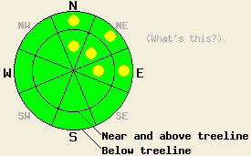
March 5, 2013 at 8:00 Pockets of MODERATE avalanche danger exist on the N-NE-E aspects above 7500 ft. Above treeline small winds slabs have started to form and below treeline small human-triggered loose snow avalanches remain possible in these areas on slopes 35 degrees and steeper. The avalanche danger will increase as more snow and wind impact the region tonight and tomorrow. |
 |
|
Click here to see the full forecast for 2013-03-06 |
March 6, 2013 at 8:00 Near and above treeline the avalanche danger is CONSIDERABLE on NW-N-NE-E-SE aspects on slopes steeper than 35 degrees due to new snow and wind forming unstable wind slabs. Below treeline pockets of CONSIDERABLE danger exist on those same aspects due to fragile soft storm slabs and some wind slabs. Human-triggered avalanches are likely today and natural avalanches are possible. |
 |
|
Click here to see the full forecast for 2013-03-07 |
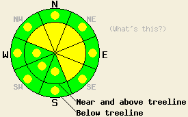
March 7, 2013 at 7:58 Near and above treeline, areas of MODERATE avalanche danger exist on all aspects on slopes steeper than 35 degrees due to recently formed wind slabs. Below treeline, pockets of MODERATE avalanche danger exist on all aspects on slopes steeper than 35 degrees due to recently formed storm slabs. |
 |
|
Click here to see the full forecast for 2013-03-08 |
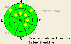
March 8, 2013 at 7:47 Near and above treeline, avalanche danger is LOW with pockets of MODERATE danger on NW-N-NE-E-SE aspects on slopes steeper than 35 degrees due to lingering wind slabs. Below treeline, avalanche danger is LOW with pockets of MODERATE danger on NW-N-NE aspects on slopes steeper than 35 degrees due to lingering storm slabs. Areas of unstable snow will exist within surrounding areas of stable snow. |
 |
|
Click here to see the full forecast for 2013-03-09 |
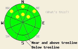
March 9, 2013 at 8:01 Both above and below treeline, avalanche danger is LOW with pockets of MODERATE avalanche danger on NW-N-NE aspects on slopes 35 degrees and steeper due to the presence of persistent slabs in some areas. Expect to find localized areas of instability within large surrounding areas of stable snow. |
 |
|
Click here to see the full forecast for 2013-03-10 |
March 10, 2013 at 7:07 Both above and below treeline, areas of MODERATE avalanche danger exist on all aspects on slopes 35 degrees and steeper due to a combination of persistent slabs, new wind slabs, and wet snow instabilities in some areas. Expect to find localized areas of instability within large surrounding areas of stable snow. |
 |
|
Click here to see the full forecast for 2013-03-11 |
March 11, 2013 at 7:00 Both above and below treeline, areas of MODERATE avalanche danger exist on all aspects on slopes 35 degrees and steeper due to a combination of persistent slabs, wind slabs, and wet snow instabilities in some areas. Human triggered avalanches remian possible today. Expect to find areas of instability within large surrounding areas of stable snow. |
 |
|
Click here to see the full forecast for 2013-03-12 |
March 12, 2013 at 7:00 Both above and below treeline, areas of MODERATE avalanche danger exist on all aspects on slopes 35 degrees and steeper due to a combination of persistent slabs, wind slabs, and wet snow instabilities. Human triggered avalanches remain possible today. Areas of instability may exist near areas of stable snow. |
 |
|
Click here to see the full forecast for 2013-03-13 |
March 13, 2013 at 6:59 Both above and below treeline, areas of MODERATE avalanche danger exist on all aspects on slopes 35 degrees and steeper due to a combination of persistent slabs on NW-N-NE aspects and wet snow instability on all aspects. |
 |
|
Click here to see the full forecast for 2013-03-14 |
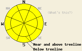
March 14, 2013 at 6:53 MODERATE avalanche danger will exist today on all aspects and at all elevations on slopes 35 degrees and steeper. This is due to wet snow instability on all aspects and the possibility of isolated, lingering persistent slabs above 8,000' on NW-N-NE aspects. |
 |
|
Click here to see the full forecast for 2013-03-15 |
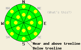
March 15, 2013 at 6:51 Early this morning, avalanche danger is LOW for all elevations and aspects. Pockets of MODERATE avalanche danger will form today both above and below treeline on all aspects on slopes 35 degrees and steeper in response to daytime warming. As snow surface melting progresses, human triggered loose wet avalanches will become possible. |
 |
|
Click here to see the full forecast for 2013-03-16 |
March 16, 2013 at 6:54 This morning the avalanche danger is LOW for all elevations and aspects. Pockets of MODERATE avalanche danger may form both above and below treeline on all aspects on slopes 35 degrees and steeper due to daytime warming. Human triggered loose wet avalanches will become possible. |
 |
|
Click here to see the full forecast for 2013-03-17 |
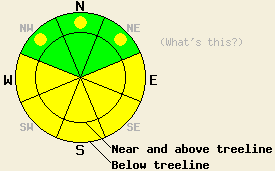
March 17, 2013 at 7:00 This morning the avalanche danger is LOW for all elevations and aspects. MODERATE avalanche danger may form on the E-SE-S-SW-W aspects in both above and below treeline terrain on slopes steeper than 35 degrees due to daytime warming. Some pockets of MODERATE danger could also form on the below treeline NW-N-NE aspects. Human triggered wet snow avalanches will become possible. |
 |
|
Click here to see the full forecast for 2013-03-18 |
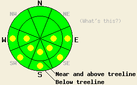
March 18, 2013 at 6:59 This morning the avalanche danger is LOW for all elevations and aspects. Pockets of MODERATE avalanche danger may form on the E-SE-S-SW-W aspects in both above and below treeline terrain on slopes steeper than 35 degrees due to daytime warming. Human triggered wet snow avalanches will become possible. |
 |
|
Click here to see the full forecast for 2013-03-19 |
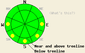
March 19, 2013 at 6:43 This morning, avalanche danger is LOW for all elevations and aspects. Pockets of MODERATE avalanche danger may form this afternoon on the E-SE-S-SW-W aspects below 8,000' on slopes 35 degrees and steeper due to daytime warming. Human triggered wet snow avalanches may become possible. |
 |
|
Click here to see the full forecast for 2013-03-20 |
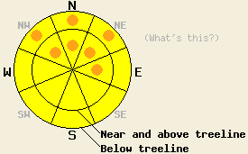
March 20, 2013 at 7:00 Increasing avalanche danger this morning will rise to widespread MODERATE danger with pockets of CONSIDERABLE danger forming today in near and above treeline areas on NW-N-NE-E aspects on slopes 35 degrees and steeper as wind slabs continue to grow in size and depth. Pockets of CONSIDERABLE danger are possible in below treeline areas below 7,500' as rain on snow keeps the possibility of loose wet snow avalanches ongoing, especially on NW-N-NE aspects on slopes 37 degrees and steeper. |
 |
|
Click here to see the full forecast for 2013-03-21 |
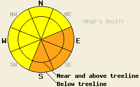
March 21, 2013 at 7:01 Both above and below treeline, CONSIDERABLE avalanche danger is expected to today on E-SE-S aspects on slopes 35 degrees and steeper due to the possibility of natural and human triggered loose wet and wet slab avalanches. For all other areas, avalanche danger is MODERATE due to a mix of wet snow instability and lingering wind slab instability on slopes 35 degrees and steeper. |
 |
|
Click here to see the full forecast for 2013-03-22 |
March 22, 2013 at 7:00 Both above and below treeline, pockets of MODERATE avalanche danger will exist on all aspects on slopes 35 degrees and steeper due to a combination of new and old wind slabs and wet snow instabilities formed by sunshine and daytime warming. |
 |
|
Click here to see the full forecast for 2013-03-23 |
March 23, 2013 at 7:00 In above treeline terrain, a few isolated pockets of MODERATE avalanche danger may remain on NW-N-NE-E aspects on slopes 35 degrees and steeper due to lingering wind slabs. Below treeline pockets of MODERATE avalanche danger may form due to daytime warming on the sun-exposed E-SE-S-SW-W aspects on slopes steeper than 35 degrees. |
 |
|
Click here to see the full forecast for 2013-03-24 |
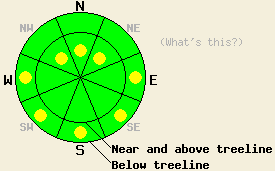
March 24, 2013 at 7:00 In near and above treeline terrain, a few isolated pockets of MODERATE avalanche danger may remain on NW-N-NE aspects on slopes 35 degrees and steeper due to lingering wind slabs. Below treeline pockets of MODERATE avalanche danger may form due to daytime warming on the sun-exposed E-SE-S-SW-W aspects on slopes steeper than 35 degrees. |
 |
|
Click here to see the full forecast for 2013-03-25 |
March 25, 2013 at 6:48 Avalanche danger is LOW for all elevations and aspects. Isolated areas of loose wet snow instability may form during the afternoon hours on open sun exposed slopes 37 degrees and steeper. |
 |
|
Click here to see the full forecast for 2013-03-26 |
March 26, 2013 at 6:32 Avalanche danger is LOW for all elevations and aspects. Normal caution is advised. |
 |
|
Click here to see the full forecast for 2013-03-27 |
March 27, 2013 at 6:35 Avalanche danger is LOW for all elevations and aspects. Normal caution is advised. |
 |
|
Click here to see the full forecast for 2013-03-28 |
March 28, 2013 at 7:00 Avalanche danger is LOW for all elevations and aspects. Continue to use normal caution when travelling in the backcountry. |
 |
|
Click here to see the full forecast for 2013-03-29 |
March 29, 2013 at 7:00 This morning, avalanche danger is LOW for all elevations and aspects. Pockets of MODERATE avalanche danger may form today on slopes steeper than 37 degrees below 8,000' due to daytime warming and possible rain on snow this afternoon. Small human triggered wet loose avalanches may become possible in some areas. |
 |
|
Click here to see the full forecast for 2013-03-30 |
March 30, 2013 at 7:00 Pockets of MODERATE avalanche danger will form today on slopes steeper than 37 degrees below 8,000' due to daytime warming and rain on snow. Human triggered wet loose avalanches will be possible in some areas. |
 |
|
Click here to see the full forecast for 2013-03-31 |
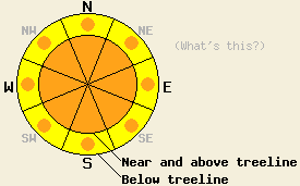
March 31, 2013 at 6:55 Near and above treeline, avalanche danger is CONSIDERABLE on all aspects on slopes 35 degrees and steeper. Below treeline, avalanche danger is MODERATE with pockets of CONSIDERABLE danger on all aspects on slopes 35 degrees and steeper. Natural and human triggered storm slab avalanches are possible today along with human triggered loose wet avalanches. |
 |
|
Click here to see the full forecast for 2013-04-01 |
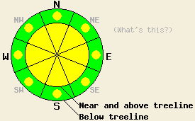
April 1, 2013 at 6:40 Above 7,000', avalanche danger is MODERATE on all aspects on slopes 35 degrees and steeper due to a mix of storms slabs and wind slabs. Below 7,000', avalanche danger is LOW with pockets of MODERATE danger on all aspects on slopes 35 degrees and steeper due to the possibility of human triggered loose wet avalanches. |
 |
|
Click here to see the full forecast for 2013-04-02 |
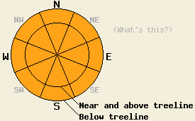
April 2, 2013 at 6:45 Both above and below treeline, CONSIDERABLE danger will form quickly today on all aspects and at all elevations on slopes 35 degrees and steeper due to loose wet snow avalanches. Shallow naturally occurring loose wet avalanches are expected. Human triggered loose wet avalanches of greater size are likely. |
 |
|
Click here to see the full forecast for 2013-04-03 |
April 3, 2013 at 7:00 Both above and below treeline, MODERATE danger will form on all aspects and elevations on slopes 35 degrees and steeper due to daytime warming. Human triggered loose wet avalanches remain possible today. |
 |
|
Click here to see the full forecast for 2013-04-04 |
April 4, 2013 at 7:00 Both above and below treeline, MODERATE danger will form on all aspects below 8500 ft. on slopes 35 degrees and steeper due to rain on snow. Human triggered loose wet avalanches remain possible today. |
 |
|
Click here to see the full forecast for 2013-04-05 |
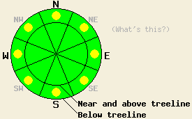
April 5, 2013 at 7:00 Below 8000 ft. pockets of MODERATE danger exist on all aspects on slopes 35 degrees and steeper. Human triggered loose wet avalanches remain possible today in some areas. |
 |
|
Click here to see the full forecast for 2013-04-06 |
April 6, 2013 at 6:43 Avalanche danger is LOW for all elevations and aspects. Very isolated pockets of wind slab exist in recently wind loaded areas above treeline. Normal caution is advised. |
 |
|
Click here to see the full forecast for 2013-04-07 |
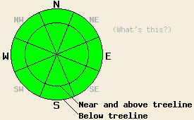
April 7, 2013 at 6:40 For most of today, avalanche danger will remain LOW for all elevations and aspects. Very isolated pockets of lingering wind slab may exist in recently wind loaded areas above treeline. After 5 pm today, pockets of MODERATE avalanche danger are expected to form in near treeline and above treeline terrain mainly on N-NE-E aspects as additional snowfall and wind create new wind slabs. |
 |
|
Click here to see the full forecast for 2013-04-08 |
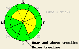
April 8, 2013 at 6:40 Near and above treeline, areas of MODERATE avalanche danger exist on NW-N-NE-E-SE aspects on slopes 35 degrees and steeper due to newly formed wind slabs. For all other areas, avalanche danger remains LOW. |
 |
|
Click here to see the full forecast for 2013-04-09 |
April 9, 2013 at 7:00 Near and above treeline, very isolated pockets of MODERATE avalanche danger exist on E-SE-S-SW-W-NW aspects on slopes 35 degrees and steeper due to small shallow wind slabs. For all other areas, avalanche danger remains LOW. |
|
|
Click here to see the full forecast for 2013-04-10 |
April 10, 2013 at 6:39 This morning the avalanche danger is LOW. As the day warms up, small pockets of MODERATE avalanche danger may form on E-SE-S-SW-W aspects on slopes 35 degrees and steeper due to daytime warming creating small shallow wet snow instabilities. |
|
|
Click here to see the full forecast for 2013-04-11 |
April 11, 2013 at 7:00 Small pockets of MODERATE avalanche danger may exist on near and below treeline slopes steeper than 35 degrees that received rain last night and this morning. Daytime warming may also cause small shallow wet snow instabilities to form. |
|
|
Click here to see the full forecast for 2013-04-12 |
April 12, 2013 at 6:32 Early this morning, avalanche danger is LOW for all elevations and aspects. As the day progresses, areas of MODERATE danger will form on all aspects at all elevations on slopes 37 degrees and steeper in response to daytime warming. Small human triggered loose wet avalanches will become possible. |
|
|
Click here to see the full forecast for 2013-04-13 |
April 13, 2013 at 6:36 Early this morning, avalanche danger is LOW for all elevations and aspects. As the day progresses, areas of MODERATE danger will form on all aspects at all elevations on slopes 37 degrees and steeper in response to daytime warming. Small human triggered loose wet avalanches will become possible. |
|
|
Click here to see the full forecast for 2013-04-14 |
April 14, 2013 at 6:39 Early this morning, avalanche danger is LOW for all elevations and aspects. As the day progresses, areas of MODERATE danger will form on all aspects at all elevations on slopes 37 degrees and steeper in response to daytime warming. Small human triggered loose wet avalanches will become possible. |
|
|
Click here to see the full forecast for 2013-04-15 |
April 15, 2013 at 6:50 We have stopped issuing daily avalanche advisories for the 2012-2013 season. Avalanche advisories will resume in fall of 2013. The avalanche danger can and will change quickly this spring. Continue to monitor changing conditions and use caution when traveling in the backcountry. For general spring avalanche information read the full spring avalanche statement. |
|
|
Click here to see the full forecast for 2013-09-21 |
September 21, 2013 at 11:14 Fall storms are starting to impact the forecast area with rain and high elevation snow returning to the Sierra. The operational portion of the avalanche center has yet to brush off the dust accumulated during the summer hiatus. As mid/late October approaches, work will resume to get the operational program ready to issue regular avalanche advisories once conditions warrant. The non-profit fundraising portion of the avalanche center has been hard at work organizing fall events. Take a look at the SAC calendar for upcoming events to fuel your excitement. |
|
|
Click here to see the full forecast for 2013-10-28 |
October 28, 2013 at 14:45 Fall Avalanche Statement Daily avalanche advisories are planned to resume in mid November or later as conditions dictate. Occasional intermittent early season updates to this page will occur earlier as conditions warrant. |
|
|
Click here to see the full forecast for 2013-11-13 |
November 13, 2013 at 15:30 Early season conditions update #1. We are operational! Snowpack observations have begun. Daily avalanche advisories will resume as soon as conditions warrant. |
|
|
Click here to see the full forecast for 2013-11-19 |
November 19, 2013 at 15:13 Easly season conditions update #2. We are still without sufficient snowcover to warrant daily avalanche advisories. We are making snowpack observations and posting them to the observations page. |
|
|
Click here to see the full forecast for 2013-11-26 |
November 26, 2013 at 13:37 Early season conditions update #3. We are still without sufficient snow cover to warrant daily avalanche advisories. We are making snowpack observations and posting them to the observations page. |
|
|
Click here to see the full forecast for 2013-12-03 |
December 3, 2013 at 14:31 Early season conditions update #4. The snowpack is slowly building. At this time we are still without sufficient snow cover to warrant daily avalanche advisories. We are making snowpack observations and posting them to the observations page. |
|
|
Click here to see the full forecast for 2013-12-07 |
December 7, 2013 at 6:51 Widespread areas of CONSIDERABLE avalanche danger exist near and above treeline on NW-N-NE-E-SE aspects 30 degrees and steeper due to newly formed wind slabs and below treeline on NW-N-NE aspects 30 degrees and steeper due to persistent slabs. Natural avalanches are possible, human triggered avalanches are likely today. Significant avalanche danger exists below treeline. --- Everyone is chomping at the bit to get out there today. Only a small percentage have a handle on the weakness of the existing snowpack and the reality of avalanches today. Conservative terrain selection and effective group communication are imperative. |
|
|
Click here to see the full forecast for 2013-12-08 |
December 8, 2013 at 6:41 CONSIDERABLE avalanche danger exists at all elevations on NW-N-NE aspects 30 degrees and steeper due to a combination of lingering wind slabs and widespread persistent slabs. Human triggered avalanches remain likely today especially in near and below treeline areas where the persistent slabs exist and in above treeline areas where wind slabs sit on persistent weak layers. Remotely triggered avalanches can occur under these conditions. In addition to the avalanche danger a myriad of season-ending obstacles still lurks just below the surface. Don't let "powder-fever" cloud your judgement. Conservative terrain selection, careful snowpack evaluation, and conservative decision-making are essential. |
|
|
Click here to see the full forecast for 2013-12-09 |
December 9, 2013 at 6:30 CONSIDERABLE avalanche danger exists in near and below treeline terrain on NW-N-NE aspects 30 degrees and steeper due to widespread persistent slabs. Human triggered persistent slabs remain likely today in near and below treeline terrain. Remotely triggered avalanches can occur under these conditions. MODERATE avalanche danger remains on the near and above treeline NW-N-NE-E-SE aspects due to lingering wind slabs. In addition to the avalanche danger a myriad of season-ending obstacles still lurks just below the surface. Conservative terrain selection, careful snowpack evaluation, and conservative decision-making are essential. |
|
|
Click here to see the full forecast for 2013-12-10 |
December 10, 2013 at 6:54 On slopes steeper than 30 degrees, MODERATE avalanche danger exists at all elevations on NW-N-NE aspects an on the near and above treeline E-SE aspects due to a combination of widespread persistent slabs and lingering wind slabs. Human triggered persistent slabs remain possible in near and below treeline terrain. Remotely triggered avalanches can occur under these conditions. In addition to the avalanche danger a myriad of season-ending obstacles still lurks just below the surface. Conservative terrain selection, careful snowpack evaluation, and conservative decision-making are essential. I will update the advisory next on Thurday morning at 7am. |
|
|
Click here to see the full forecast for 2013-12-12 |
December 12, 2013 at 6:49 On slopes steeper than 32 degrees, MODERATE avalanche danger exists on near and below treeline NW-N-NE aspects due to lingering persistent slabs. Some isolated areas of unstable snow may still remain on above treeline slopes as well. Human triggered persistent slabs remain possible in near and below treeline terrain. Remotely triggered avalanches can occur under these conditions. In addition to the avalanche danger a myriad of season-ending obstacles still lurks just below the surface. Conservative terrain selection, careful snowpack evaluation, and conservative decision-making are essential. |
|
|
Click here to see the full forecast for 2013-12-13 |
December 13, 2013 at 6:54 On slopes steeper than 32 degrees, MODERATE avalanche danger exists on near and below treeline NW-N-NE aspects due to lingering persistent slabs. Human triggered persistent slabs remain possible. Remotely triggered avalanches can occur under these conditions. Some isolated areas of unstable snow may still remain on above treeline slopes as well. In addition to the avalanche danger a myriad of season-ending obstacles still lurks just below the surface. Conservative terrain selection, careful snowpack evaluation, and conservative decision-making are essential. |
|
|
Click here to see the full forecast for 2013-12-14 |
December 14, 2013 at 6:43 MODERATE avalanche danger continues near treeline and below treeline on NW-N-NE aspects on slopes 32 degrees and steeper due to ongoing instability of persistent slabs. Human triggered avalanches remain possible. Pay attention to the big picture of surrounding terrain and the presence of steeper slopes above. Understand that remote triggering of avalanches from low angle slopes below to steeper slopes above is very possible under the current snowpack conditions. |
|
|
Click here to see the full forecast for 2013-12-15 |
December 15, 2013 at 6:40 MODERATE avalanche danger continues near treeline and below treeline on NW-N-NE aspects on slopes 32 degrees and steeper due to ongoing persistent slab instability. Current conditions are very conducive to human triggered avalanches. Use low angle (sub 30 degree) slopes for protection. Stay clear of areas connected to steeper slopes above. Conservative terrain choices and effective communication are critical given the current instability. |
|
|
Click here to see the full forecast for 2013-12-16 |
December 16, 2013 at 6:59 MODERATE avalanche danger continues near treeline and below treeline on NW-N-NE aspects on slopes 32 degrees and steeper due to ongoing persistent slab instability. Current conditions are still very conducive to human triggered avalanches. Give this snowpack the respect it deserves. It is playing by its own set of rules. |
|
|
Click here to see the full forecast for 2013-12-17 |
December 17, 2013 at 6:30 Avalanche danger remains MODERATE near treeline and below treeline on NW-N-NE aspects on slopes 32 degrees and steeper due to ongoing persistent slab instability. Current conditions remain conducive to human triggered avalanches. |
|
|
Click here to see the full forecast for 2013-12-18 |
December 18, 2013 at 7:00 MODERATE avalanche danger still persists on near treeline and below treeline NW-N-NE aspects on slopes 32 degrees and steeper due to lingering persistent slabs. Human triggered avalanches remain possible. Due to the shallow snowpack any avalanches that do occur would drag people through and into obstacles like rocks, stumps, and other hard immobile obstacles. |
|
|
Click here to see the full forecast for 2013-12-19 |
December 19, 2013 at 7:00 MODERATE avalanche danger will continue on the near and below treeline NW-N-NE aspects on slopes 32 degrees and steeper due to lingering persistent slabs. Human triggered avalanches remain possible. Due to the shallow snowpack any avalanches that do occur would drag people through and into obstacles like rocks, stumps, and other hard immobile obstacles. |
|
|
Click here to see the full forecast for 2013-12-20 |
December 20, 2013 at 6:35 MODERATE avalanche danger will continue on the near and below treeline NW-N-NE aspects on slopes 32 degrees and steeper due to lingering persistent slabs. Human triggered avalanches remain possible. Due to the shallow snowpack any avalanches that do occur would drag people through and into obstacles like rocks, stumps, and other hard immobile obstacles. |
|
|
Click here to see the full forecast for 2013-12-21 |
December 21, 2013 at 6:49 Near treeline and below treeline, MODERATE avalanche danger continues on NW-N-NE aspects on slopes 32 degrees and steeper due to lingering persistent slabs. Human triggered avalanches remain possible. Shallow covered rocks, logs, and stumps are an additional hazard to backcountry travelers. Impact with rocks or trees while caught in an avalanche can greatly increase consequences. |
|
|
Click here to see the full forecast for 2013-12-22 |
December 22, 2013 at 6:43 Near treeline and below treeline, MODERATE avalanche danger continues on NW-N-NE aspects on slopes 32 degrees and steeper due to lingering persistent slabs. Human triggered avalanches remain possible. Shallow covered rocks, logs, and stumps are an additional hazard to backcountry travelers. Impact with rocks or trees while caught in an avalanche can greatly increase consequences. |
|
|
Click here to see the full forecast for 2013-12-23 |
December 23, 2013 at 6:38 Near treeline and below treeline, MODERATE avalanche danger continues on NW-N-NE aspects on slopes 32 degrees and steeper due to lingering persistent slabs. Human triggered avalanches remain possible. Shallow covered rocks, logs, and stumps are an additional hazard to backcountry travelers. Impact with rocks or trees while caught in an avalanche can greatly increase consequences. |
|
|
Click here to see the full forecast for 2013-12-24 |
December 24, 2013 at 7:01 MODERATE avalanche danger still lingers on near and below treeline NW-N-NE aspects on slopes steeper than 32 degrees because persistent slabs still remain in those areas. Human triggered avalanches remain possible. Barely covered rocks, logs, stumps and other obstacles would increase the consequences of any avalanches that do occur. I will update the advisory again on Dec. 26 at 7:00 am. |
|
|
Click here to see the full forecast for 2013-12-26 |
December 26, 2013 at 6:58 Near and below treeline NW-N-NE aspects still hold MODERATE avalanche danger on slopes steeper than 32 degrees because persistent slabs still remain in those areas. Human triggered avalanches remain possible. Barely covered rocks, logs, stumps and other obstacles would increase the consequences of any avalanches that do occur. |
|
|
Click here to see the full forecast for 2013-12-27 |
December 27, 2013 at 6:41 Near treeline and below treeline avalanche danger remains MODERATE on NW-N-NE aspects on slopes steeper than 32 degrees due to lingering persistent slab instability. Human triggered avalanches remain possible. |
|
|
Click here to see the full forecast for 2013-12-28 |
December 28, 2013 at 6:56 Avalanche danger remains MODERATE near treeline and below treeline on NW-N-NE aspects on slopes steeper than 32 degrees due to lingering persistent slab instability. Signs of snowpack instability are still observed on a near daily basis. Human triggered avalanches are possible. |
|
|
Click here to see the full forecast for 2013-12-29 |
December 29, 2013 at 6:40 Avalanche danger remains MODERATE near treeline and below treeline on NW-N-NE aspects on slopes steeper than 32 degrees due to lingering persistent slab instability. Ongoing signs of snowpack instability have been observed on a regular basis. Human triggered avalanches remain possible. |
|
|
Click here to see the full forecast for 2013-12-30 |
December 30, 2013 at 7:00 MODERATE avalanche danger still exists near and below treeline on NW-N-NE aspects on slopes steeper than 32 degrees due to lingering persistent slab instability. Even though these slabs have become more difficult to trigger, human triggered avalanches remain possible in places where consistent snow cover exists. |
|
|
Click here to see the full forecast for 2013-12-31 |
December 31, 2013 at 7:00 MODERATE avalanche danger still exists near and below treeline on NW-N-NE aspects on slopes steeper than 32 degrees where consistent snow cover exists due to lingering persistent slab instability. Human triggered avalanches remain possible. Brandon will update the advisory again in 2014 on Jan. 2 at 7:00 am. |
|
|
Click here to see the full forecast for 2014-01-02 |
January 2, 2014 at 6:00 Pockets of MODERATE avalanche danger remain near and below treeline on NW-N-NE aspects on slopes steeper than 32 degrees where consistent snow cover exists. Lingering persistent slabs are keeping the possibility of human triggered avalanches ongoing in certain areas near treeline and below treeline on NW-N-NE aspects. For all other areas avalanche danger is either LOW or non-existent due to the lack of snow cover. |
|
|
Click here to see the full forecast for 2014-01-03 |
January 3, 2014 at 6:42 Pockets of MODERATE avalanche danger remain near and below treeline on NW-N-NE aspects on slopes steeper than 32 degrees with consistent snow cover due to lingering persistent slabs. In these areas, the possibility of human triggered avalanches remains ongoing. For all other areas avalanche danger is either LOW or non-existent due to the lack of snow cover. |
|
|
Click here to see the full forecast for 2014-01-04 |
January 4, 2014 at 6:53 Pockets of MODERATE avalanche danger remain near treeline and below treeline on NW-N-NE aspects on slopes steeper than 32 degrees with consistent snow cover. This is due to lingering persistent slabs. In these areas, the possibility of human triggered avalanches remains ongoing. For all other areas avalanche danger is either LOW or non-existent due to the lack of snow cover. |
|
|
Click here to see the full forecast for 2014-01-05 |
January 5, 2014 at 7:00 Some pockets of MODERATE avalanche danger still exist on near treeline and below treeline NW-N-NE aspects steeper than 32 degrees where consistent snow cover exists. Persistent slabs continue to lurk in these areas. Human triggered avalanches remain possible where these pockets MODERATE avalanche danger still exist. Lack of snow in all other areas has made the avalanche danger LOW or non-existent. |
|
|
Click here to see the full forecast for 2014-01-06 |
January 6, 2014 at 6:59 Pockets of MODERATE avalanche danger may still exist on near and below treeline NW-N-NE aspects steeper than 32 degrees where consistent snow cover exists. Persistent slabs continue to lurk in these areas. Human triggered avalanches remain possible in these places. Lack of snow in all other areas has made the avalanche danger LOW or non-existent. |
|
|
Click here to see the full forecast for 2014-01-07 |
January 7, 2014 at 7:00 The avalanche danger has dropped to LOW on all snow covered slopes due to a shrinking snowpack. Human triggered avalanches are unlikely today but not impossible. Some persistent slabs may continue to lurk on isolated terrain features. The SE-S-SW-W aspects do not have enough snow cover on them to warrant a danger rating. |
|
|
Click here to see the full forecast for 2014-01-08 |
January 8, 2014 at 6:51 Avalanche danger is LOW for snow covered areas at all elevations on NW-N-NE-E aspects. For all other areas, avalanche danger is generally non-existant due to a lack of snow cover. |
|
|
Click here to see the full forecast for 2014-01-09 |
January 9, 2014 at 6:51 Avalanche danger is LOW for snow covered areas at all elevations on NW-N-NE-E aspects. For all other areas, avalanche danger is generally nonexistent due to a lack of snow cover. |
|
|
Click here to see the full forecast for 2014-01-10 |
January 10, 2014 at 6:47 Avalanche danger is LOW for snow covered areas at all elevations on NW-N-NE-E aspects. For all other areas, avalanche danger is generally nonexistent due to a lack of snow cover. |
|
|
Click here to see the full forecast for 2014-01-11 |
January 11, 2014 at 7:05 This morning the avalanche danger remains LOW for areas with consistent snow cover. As snow and wind impact the region some pockets of MODERATE avalanche danger may form on near and above treeline NW-N-NE-E-SE aspects steeper than 32 degrees. The most likley places where human triggered avalanches could become possible are the near treeline NW-N-NE aspects where the wind slabs could sit on top of persistent weak layers. |
|
|
Click here to see the full forecast for 2014-01-12 |
January 12, 2014 at 7:00 The avalanche danger is LOW for most areas with consistent snow cover and nonexistent for areas without snow. On a few of the near treeline NW-N-NE aspects that received the most snow yesterday, some pockets of MODERATE avalanche danger may exist where human triggered avalanches may be possible on slopes steeper than 32 degrees. These more fragile areas are mostly likely to exist where small wind slabs formed above persistent weak layers. |
|
|
Click here to see the full forecast for 2014-01-13 |
January 13, 2014 at 7:00 The avalanche danger has returned to LOW on all snow covered slopes. Human triggered avalanches are unlikely today but not impossible. Some unstable snow may continue to lurk on isolated terrain features. The SE-S-SW-W aspects do not have enough snow cover on them to warrant a danger rating. |
|
|
Click here to see the full forecast for 2014-01-14 |
January 14, 2014 at 6:53 Avalanche danger is LOW at all elevations on snow covered NW-N-NE-E aspects. Human triggered avalanches are unlikely but not impossible. Isolated areas of unstable snow may exist on isolated terrain features. Due to melt, avalanche danger on SE-S-SW-W aspects is generally nonexistent. |
|
|
Click here to see the full forecast for 2014-01-15 |
January 15, 2014 at 6:42 Avalanche danger is LOW for all elevations on snow covered NW-N-NE-E aspects. Human triggered avalanches are unlikely at this time. Encountering an isolated area of unstable snow has become unlikely, but may still be possible due to the variability that can exist on a regional scale. Due to melt, avalanche danger on SE-S-SW-W aspects is generally nonexistent. |
|
|
Click here to see the full forecast for 2014-01-16 |
January 16, 2014 at 6:44 Avalanche danger is LOW for all elevations on snow covered NW-N-NE-E aspects. Encountering an isolated area of unstable snow has become unlikely, but may still be possible due to the variability that can exist on a regional scale. Due to melt, avalanche danger on SE-S-SW-W aspects is generally nonexistent. |
|
|
Click here to see the full forecast for 2014-01-17 |
January 17, 2014 at 7:00 Avalanche danger remains LOW on snow covered NW-N-NE-E aspects. A few small areas of unstable snow may still exist on isolated terrain features. On SE-S-SW-W aspects a lack of snow makes the avalanche danger generally nonexistent. |
|
|
Click here to see the full forecast for 2014-01-18 |
January 18, 2014 at 6:48 Avalanche danger remains LOW on snow covered NW-N-NE-E aspects. A few small areas of unstable snow may still exist on isolated terrain features. The avalanche danger on SE-S-SW-W aspects remains nonexistent due to a lack of snow. |
|
|
Click here to see the full forecast for 2014-01-19 |
January 19, 2014 at 6:56 Avalanche danger remains LOW on snow covered NW-N-NE-E aspects. Overall, triggering an avalanche has become unlikely, but a few small areas of unstable snow may still exist on isolated terrain features. The avalanche danger on SE-S-SW-W aspects remains nonexistent due to a lack of snow. Brandon will update the advisory by Tuesday at 7am. |
|
|
Click here to see the full forecast for 2014-01-21 |
January 21, 2014 at 6:45 Avalanche danger is LOW at all elevations on snow covered NW-N-NE-E aspects. Avalanche danger is generally nonexistent on SE-S-SW-W aspects due to a lack of snowcover. |
|
|
Click here to see the full forecast for 2014-01-22 |
January 22, 2014 at 6:40 Avalanche danger is LOW at all elevations on snow covered NW-N-NE-E aspects. Avalanche danger is generally nonexistent on SE-S-SW-W aspects due to a lack of snowcover. |
|
|
Click here to see the full forecast for 2014-01-23 |
January 23, 2014 at 6:59 Avalanche danger remains LOW at all elevations on snow covered NW-N-NE-E aspects. Avalanche danger and snow cover are generally nonexistent on SE-S-SW-W aspects. |
|
|
Click here to see the full forecast for 2014-01-24 |
January 24, 2014 at 6:57 Avalanche danger remains LOW at all elevations on snow covered NW-N-NE-E aspects. Avalanche danger and snow cover are generally nonexistent on SE-S-SW-W aspects. |
|
|
Click here to see the full forecast for 2014-01-25 |
January 25, 2014 at 6:50 Avalanche danger remains LOW at all elevations on snow covered NW-N-NE-E aspects. Avalanche danger and snow cover are generally nonexistent on SE-S-SW-W aspects. |
|
|
Click here to see the full forecast for 2014-01-26 |
January 26, 2014 at 6:58 Avalanche danger remains LOW at all elevations on snow covered NW-N-NE-E aspects. Avalanche danger is generally nonexistent on SE-S-SW-W aspects due to the lack of snow cover. |
|
|
Click here to see the full forecast for 2014-01-27 |
January 27, 2014 at 6:50 An increase in avalanche danger my occur tonight into tomorrow. For today avalanche danger remains LOW at all elevations on snow covered NW-N-NE-E aspects. Avalanche danger is generally nonexistent on SE-S-SW-W aspects due to the lack of snow cover. The possibility of rain on snow tonight has the potential to increase avalanche danger. Depending on how much rain reaches the ground, natural wet loose snow avalanches could occur late tonight and early tomorrow morning. |
|
|
Click here to see the full forecast for 2014-01-28 |
January 28, 2014 at 6:51 For today, avalanche danger is generally LOW. Pockets of MODERATE danger may form on NW-N-NE-E aspects on slopes 37 degrees and steeper due to rain on snow. Areas where light rain falls on sugary, faceted surface snow hold the greatest possibility of loose wet avalanches. Rain may fall as high as 8,000' to 9,500' across the forecast area today. Snow level will generally be higher in the southern half of the area. Avalanche danger is generally nonexistent on SE-S-SW-W aspects due to the lack of snow cover. |
|
|
Click here to see the full forecast for 2014-01-29 |
January 29, 2014 at 7:00 Avalanche danger remains LOW for most areas today. In areas where rain falls on the snowpack, pockets of MODERATE danger could form on NW-N-NE-E aspects on slopes steeper than 37 degrees due to the possibility of loose wet avalanches. The avalanche danger will increase tonight and tomorrow as a strong winter storm brings wind, some rain, and 1-2 ft of snow above 7000 ft. The new load on top of the already weak snowpack should cause the avalanche danger to reach HIGH meaning that natural and human triggered avalanches will become very likely tonight and tomorrow. Travel in and around avalanche terrain is not recommended tonight or during the day tomorrow. |
|
|
Click here to see the full forecast for 2014-01-30 |
January 30, 2014 at 7:00 HIGH avalanche danger exists on slopes steeper than 30 degrees in near and below treeline terrain on NW-N-NE aspects due to new heavy snow slabs sitting on top of persistent weak layers. Natural and human triggered avalanche are very likely on these slopes today. CONSIDERABLE avalanche danger exists on the wind loaded NW-N-NE-E-SE aspects in near and above treeline terrain due to the pressence of newly formed wind slabs on slopes 35 degrees and steeper. MODERATE avalanche danger exists on all other aspects. Travel in, around, or near avalanche terrain is not recommended today. |


